!['MOUTH OF THE SHATT AL ARAB RIVER' [‎104v] (2/2)](https://iiif.qdl.qa/iiif/images/81055/vdc_100000000419.0x00009f/IOR_L_PS_10_266_0223.jp2/full/!1200,1200/0/default.jpg "'MOUTH OF THE SHATT AL ARAB RIVER' [‎104v] (2/2)")
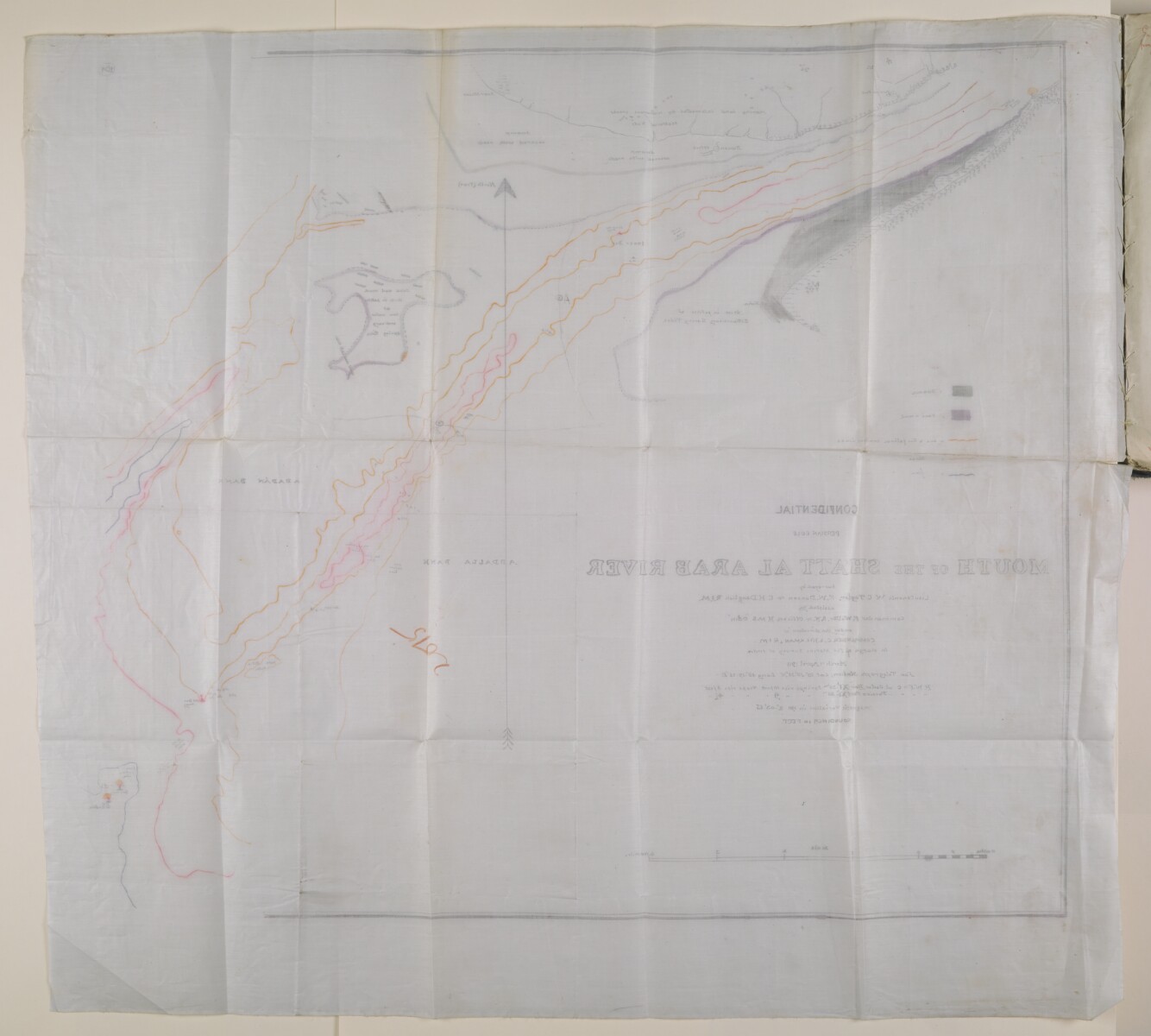
'MOUTH OF THE SHATT AL ARAB RIVER' [104v] (2/2)
The record is made up of 1 map. It was created in 1911. It was written in English. The original is part of the British Library: India Office The department of the British Government to which the Government of India reported between 1858 and 1947. The successor to the Court of Directors. Records and Private Papers Documents collected in a private capacity. .
About this item
- Content
surveyed by Lieutenants W C Taylor, E W Danson and E H Daughlish, RIM. Assisted by Commander F Walter, RN and officers of HMS Odin under the direction of Commander C S Hickman, RIM in charge of the marine survey of India. The map was surveyed March-April 1911.
The map includes a key showing the different land types, swamp, sand etc., in the area.
Wavy lines are used to denote the contours: red lines represent one to two fathoms; pink lines three fathoms; and blue lines four fathoms.
Soundings Measurements of the depth of a body of water. are given in feet.
- Extent and format
- 1 map
- Area map covers
- Map loading...
- Scale
- 1:4
- Scale designator
- Horizontal
- Orientation
- North
- Degree coordinates
- Top-left: 29° 58' 34.9" N, 48° 30' 39.56" E
Top-right: 29° 58' 34.9" N, 48° 38' 6.98" E
Bottom-left: 29° 53' 33.35" N, 48° 30' 39.56" E
Bottom-right: 29° 53' 33.35" N, 48° 38' 6.98" E - Physical characteristics
Dimensions: 825mm x 825mm
Materials: 1 tracing paper folio
- Written in
- English in Latin script View the complete information for this record
Use and share this item
- Share this item
'MOUTH OF THE SHATT AL ARAB RIVER' [104v] (2/2), British Library: India Office Records and Private Papers, IOR/L/PS/10/266, f 104, in Qatar Digital Library <https://www.qdl.qa/archive/81055/vdc_100036171272.0x000013> [accessed 18 April 2024]
https://www.qdl.qa/en/archive/81055/vdc_100036171272.0x000013
Copy and paste the code below into your web page where you would like to embed the image.
<meta charset="utf-8"><a href="https://www.qdl.qa/en/archive/81055/vdc_100036171272.0x000013">'MOUTH OF THE SHATT AL ARAB RIVER' [‎104v] (2/2)</a> <a href="https://www.qdl.qa/en/archive/81055/vdc_100036171272.0x000013"> <img src="https://iiif.qdl.qa/iiif/images/81055/vdc_100000000419.0x00009f/IOR_L_PS_10_266_0223.jp2/full/!280,240/0/default.jpg" alt="" /> </a>
This record has a IIIF manifest available as follows. If you have a compatible viewer you can drag the icon to load it.https://www.qdl.qa/en/iiif/81055/vdc_100000000419.0x00009f/manifestOpen in Universal viewerOpen in Mirador viewerMore options for embedding images
Copyright: How to use this content
- Reference
- IOR/L/PS/10/266, f 104
- Title
- 'MOUTH OF THE SHATT AL ARAB RIVER'
- Pages
- 104r:104v
- Author
- East India Company, the Board of Control, the India Office, or other British Government Department
- Usage terms
- Open Government Licence