!['Map 2' [‎142r] (1/2)](https://iiif.qdl.qa/iiif/images/81055/vdc_100000000833.0x00038a/IOR_L_PS_18_D228_0016.jp2/full/!1200,1200/0/default.jpg "'Map 2' [‎142r] (1/2)")
The record is made up of 1 map. It was created in c 1916. It was written in English. The original is part of the British Library: India Office The department of the British Government to which the Government of India reported between 1858 and 1947. The successor to the Court of Directors. Records and Private Papers Documents collected in a private capacity. .
About this item
- Content
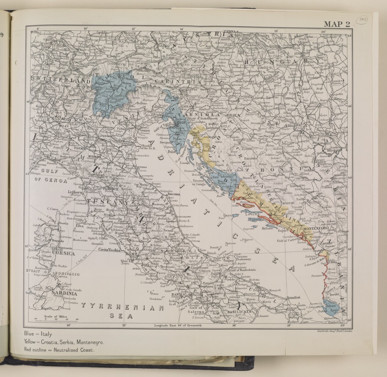
This map focuses on the territories surrounding the Adriatic Sea, and is directly related to page 2 of the synopsis (folio 136v), which provides details of an agreement Britain made with Italy in 1915. The map reflects the details of the agreement: the territory marked in blue was to be awarded to Italy, the area marked red was to be neutralised, and the yellow areas were to go to Serbia, Croatia, and Montenegro.
- Extent and format
- 1 map
- Area map covers
- Map loading...
- Scale
- Scale approximately 1:3,219,000
- Scale designator
- Horizontal
- Orientation
- North
- Degree coordinates
- Top-left: 48° 29' 15" N, 8° 11' 44.88" E
Top-right: 48° 29' 15" N, 21° 6' 56.52" E
Bottom-left: 39° 33' 17.64" N, 8° 11' 44.88" E
Bottom-right: 39° 33' 17.64" N, 21° 6' 56.52" E - Physical characteristics
Materials: 1 paper folio with coloured ink
- Written in
- English in Latin script View the complete information for this record
Use and share this item
- Share this item
'Map 2' [142r] (1/2), British Library: India Office Records and Private Papers, IOR/L/PS/18/D228, f 142, in Qatar Digital Library <https://www.qdl.qa/archive/81055/vdc_100040051411.0x00000e> [accessed 18 April 2024]
https://www.qdl.qa/en/archive/81055/vdc_100040051411.0x00000e
Copy and paste the code below into your web page where you would like to embed the image.
<meta charset="utf-8"><a href="https://www.qdl.qa/en/archive/81055/vdc_100040051411.0x00000e">'Map 2' [‎142r] (1/2)</a> <a href="https://www.qdl.qa/en/archive/81055/vdc_100040051411.0x00000e"> <img src="https://iiif.qdl.qa/iiif/images/81055/vdc_100000000833.0x00038a/IOR_L_PS_18_D228_0016.jp2/full/!280,240/0/default.jpg" alt="" /> </a>
This record has a IIIF manifest available as follows. If you have a compatible viewer you can drag the icon to load it.https://www.qdl.qa/en/iiif/81055/vdc_100000000833.0x00038a/manifestOpen in Universal viewerOpen in Mirador viewerMore options for embedding images
Copyright: How to use this content
- Reference
- IOR/L/PS/18/D228, f 142
- Title
- 'Map 2'
- Pages
- 142r:142v
- Author
- East India Company, the Board of Control, the India Office, or other British Government Department
- Usage terms
- Open Government Licence