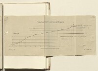
‘PROFILE ON A LINE BEARING N. 42 W. FROM A POINT 159 YARDS DISTANT N. 48 E. FROM N.E. CORNER OF SHEIKH’S COAL-SHED’
IOR/R/15/5/58, f 65
2 items in this record
Search within this record
The record is made up of 1 map. It was created in Apr 1910. It was written in English. The original is part of the British Library: India Office The department of the British Government to which the Government of India reported between 1858 and 1947. The successor to the Court of Directors. Records and Private Papers Documents collected in a private capacity. .
About this record
- Content
This topographical map which has hydrographic features, is described as ‘a map of Bunder Shweikh’ by the Second Assistant Resident at the British Residency An office of the East India Company and, later, of the British Raj, established in the provinces and regions considered part of, or under the influence of, British India. and Consulate-General, Bushire, in his letter of 30 June 1910 to the Political Agent A mid-ranking political representative (equivalent to a Consul) from the diplomatic corps of the Government of India or one of its subordinate provincial governments, in charge of a Political Agency. at Kuwait (IOR/R/15/5/58, folio 63). The map is a cross-section of the depth of the coastal water, in the vicinity of the Sheikh of Kuwait’s coal shed, the position of which is marked. A horizontal line with a marker at intervals along its length, represents actual spots where soundings Measurements of the depth of a body of water. or heights were taken by HMS Lapwing . Three other horizontal lines drawn across the map represent: the ‘Level of Doorstep of Sheikh’s Coal-shed’, ‘High Water Springs’, and ‘Low Water Springs’ respectively. The map has a vertical scale of 10 feet to 1 inch and a horizontal scale of 30 feet to 1 inch. This map is also described as an accompaniment to Bushire letter No. 1947 dated 8th August 1909. The map bears the following printing statement ‘I.B. Topo. Dy. No. 8,499'. It was executed by C J A in April 1910 and is numbered No. 5,150-I, 1910.
- Extent and format
- 1 map
- Area map covers
- Map loading...
- Scale
- Scale 1: 120
- Scale designator
- Vertical
- Orientation
- North
- Degree coordinates
- Top-left: 29° 22' 28.2" N, 47° 55' 50.88" E
Top-right: 29° 22' 28.2" N, 47° 58' 29.64" E
Bottom-left: 29° 20' 31.92" N, 47° 55' 50.88" E
Bottom-right: 29° 20' 31.92" N, 47° 58' 29.64" E - It is part of
- 389 imagesRef: IOR/R/15/5/58
- Physical characteristics
Materials: printed on paper. Dimensions: 210 mm x 480 mm.
- Written in
- English in Latin script
- Type
- Map
Archive information for this record
- Original held at
- British Library: India Office The department of the British Government to which the Government of India reported between 1858 and 1947. The successor to the Court of Directors. Records and Private Papers Documents collected in a private capacity.
- Access conditions
Unrestricted
- Archive reference
- IOR/R/15/5/58, f 65
- Date(s)
- Apr 1910 (CE, Gregorian)
Access & Reference
History of this record
Use and share this record
- Share this record
- Cite this record in your research
‘PROFILE ON A LINE BEARING N. 42 W. FROM A POINT 159 YARDS DISTANT N. 48 E. FROM N.E. CORNER OF SHEIKH’S COAL-SHED’, British Library: India Office Records and Private Papers, IOR/R/15/5/58, f 65, in Qatar Digital Library <https://www.qdl.qa/archive/81055/vdc_100041294368.0x000002> [accessed 25 April 2024]
- Link to this record
https://www.qdl.qa/en/archive/81055/vdc_100041294368.0x000002
- IIIF details
This record has a IIIF manifest available as follows. If you have a compatible viewer you can drag the icon to load it.https://www.qdl.qa/en/iiif/81055/vdc_100000000831.0x000005/manifestOpen in Universal viewerOpen in Mirador viewerMore options for embedding images
Copyright: How to use this content
- Reference
- IOR/R/15/5/58, f 65
- Title
- ‘PROFILE ON A LINE BEARING N. 42 W. FROM A POINT 159 YARDS DISTANT N. 48 E. FROM N.E. CORNER OF SHEIKH’S COAL-SHED’
- Pages
- 65r:65v
- Author
- East India Company, the Board of Control, the India Office, or other British Government Department
- Usage terms
- Open Government Licence