!['GAZETTEER OF PERSIA. VOL. III. PART I: A to K' [‎620r] (1244/1278)](https://iiif.qdl.qa/iiif/images/81055/vdc_100025472816.0x000001/IOR_L_MIL_17_15_4_1_1246.jp2/full/!1200,1200/0/default.jpg "'GAZETTEER OF PERSIA. VOL. III. PART I: A to K' [‎620r] (1244/1278)")
'GAZETTEER OF PERSIA. VOL. III. PART I: A to K' [620r] (1244/1278)
The record is made up of 1 volume (635 folios). It was created in 1924. It was written in English. The original is part of the British Library: India Office The department of the British Government to which the Government of India reported between 1858 and 1947. The successor to the Court of Directors. Records and Private Papers Documents collected in a private capacity. .
Transcription
This transcription is created automatically. It may contain errors.
KITN—KUN
6T3
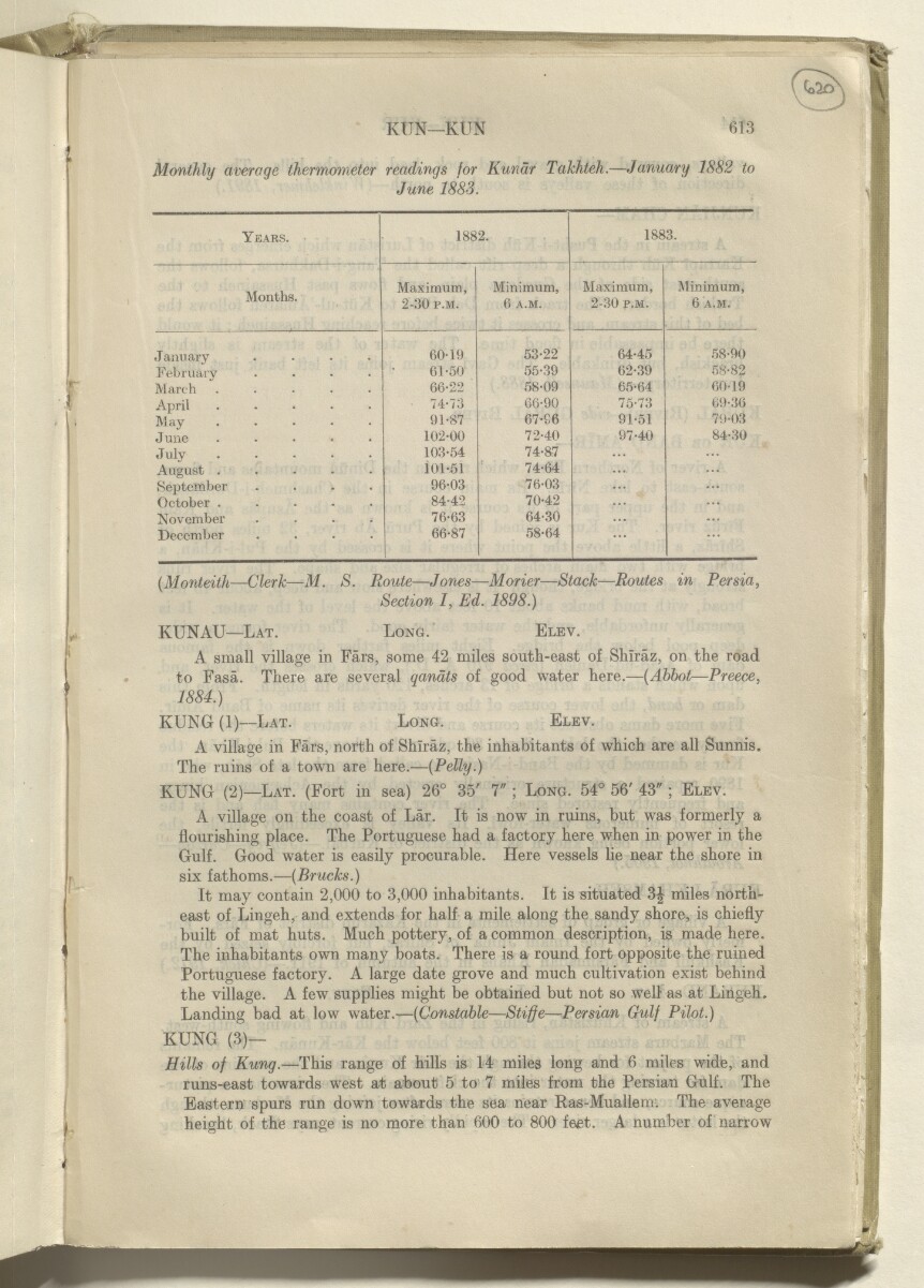
Monthly averaqe thermometer readings for Kundr Takhteh.—January 1882 to
June 1883.
Years.
1882.
1883.
Months.
Maximum,
2-30 p.m.
Minimum,
6 A.M.
Maximum,
2-30 p.m.
Minimum,
6 A.M.
January ....
60-19
53-22
64-45
58-90
February
61-50
55-39
62-39
58-82
March .....
66-22
58-09
65-64
60-19
April .....
74-73
66-90
75-73
69-36
May
91-87
67-86
91-51
79-03
June .....
102-00
72-40
97-40
84-30
July
103-54
74-87
August .....
ioi-si
74-64
September ....
96-03
76-03
...
October .....
84-42
70-42
...
November ....
76-63
64-30
...
December ....
66-87
58-64
...
(Monteith — Clerk — M. S. Route — Jones — Morier — Stack—Routes in Persia,
Section I, Ed. 1898.)
KUNAU— Lat. Long. Elev.
A small village in Ears, some 42 miles south-east of Shiraz, on the road
to Fasa. There are several qandts of good water here.— {Abbot — Preece,
1884.)
RUNG (1)—Lat. Long. Elev.
A village in Ears, north of Shiraz, the inhabitants of which are all Sunnis.
The ruins of a town are here.— {Petty.)
RUNG (2)— Lat. (Fort in sea) 26° 35' 7" ; Long. 54° 56' 43" ; Elev.
A village on the coast of Lar. It is now in ruins, but was formerly a
flourishing place. The Portuguese had a
factory
An East India Company trading post.
here when in power in the
Gulf. Good water is easily procurable. Here vessels lie near the shore in
six fathoms.— {Brucks.)
It may contain 2,000 to 3,000 inhabitants. It is situated 3| miles north
east of Lingeh, and extends for half a mile along the sandy shore, is chiefly
built of mat huts. Much pottery, of a common description, is made here.
The inhabitants own many boats. There is a round fort opposite the ruined
Portuguese
factory
An East India Company trading post.
. A large date grove and much cultivation exist behind
the village. A few supplies might be obtained but not so well as at Lingeh.
Landing bad at low water.— {Constable — Stifje—Persian Gulf Pilot.)
RUNG (3)—
Hitts of Rung. —This range of hills is 14 miles long and 6 miles wide, and
runs-east towards west at about 5 to 7 miles from the
Persian Gulf
The historical term used to describe the body of water between the Arabian Peninsula and Iran.
. The
Eastern spurs run down towards the sea near Ras-Muallem. The average
height of the range is no more than 600 to 800 feet. A number of narrow
About this item
- Content
The item is Volume III, Part I: A to K of the four-volume Gazetteer of Persia (Provisional Edition, 1917, reprinted 1924).
The volume comprises that portion of south-western Persia, which is bounded on the west by the Turco-Persian frontier; on the north and east by a line drawn through the towns of Khaniqin [Khanikin], Isfahan, Yazd, Kirman, and Bandar Abbas; and on the south by the Persian Gulf The historical term used to describe the body of water between the Arabian Peninsula and Iran. .
The gazetteer includes entries on towns, villages, districts, provinces, tribes, forts, dams, shrines, coastal features, islands, rivers, streams, lakes, mountains, passes, and camping grounds. Entries include information on history, geography, climate, population, ethnography, administration, water supply, communications, caravanserais, trade, produce, and agriculture.
Information sources are provided at the end of each gazetteer entry, in the form of an author or source’s surname, italicised and bracketed.
The volume includes an Index Map of Gazetteer and Routes in Persia (folio 636), showing the whole of Persia with portions of adjacent countries, and indicating the extents of coverage of each volume of the Gazetteer and Routes of Persia , administrative regions and boundaries, hydrology, and major cities and towns.
Printed at the Government of India Press, Simla, 1924.
- Extent and format
- 1 volume (635 folios)
- Physical characteristics
Foliation: the foliation sequence (used for referencing) commences at the front cover with 1, and terminates at the inside back cover with 637; these numbers are written in pencil, are circled, and are located in the top right corner of the recto The front of a sheet of paper or leaf, often abbreviated to 'r'. side of each folio. Pagination: the file also contains an original printed pagination sequence.
- Written in
- English in Latin script View the complete information for this record
Use and share this item
- Share this item
'GAZETTEER OF PERSIA. VOL. III. PART I: A to K' [620r] (1244/1278), British Library: India Office Records and Private Papers, IOR/L/MIL/17/15/4/1, in Qatar Digital Library <https://www.qdl.qa/archive/81055/vdc_100041319223.0x00002d> [accessed 20 April 2024]
https://www.qdl.qa/en/archive/81055/vdc_100041319223.0x00002d
Copy and paste the code below into your web page where you would like to embed the image.
<meta charset="utf-8"><a href="https://www.qdl.qa/en/archive/81055/vdc_100041319223.0x00002d">'GAZETTEER OF PERSIA. VOL. III. PART I: A to K' [‎620r] (1244/1278)</a> <a href="https://www.qdl.qa/en/archive/81055/vdc_100041319223.0x00002d"> <img src="https://iiif.qdl.qa/iiif/images/81055/vdc_100025472816.0x000001/IOR_L_MIL_17_15_4_1_1246.jp2/full/!280,240/0/default.jpg" alt="" /> </a>
This record has a IIIF manifest available as follows. If you have a compatible viewer you can drag the icon to load it.https://www.qdl.qa/en/iiif/81055/vdc_100025472816.0x000001/manifestOpen in Universal viewerOpen in Mirador viewerMore options for embedding images
Copyright: How to use this content
- Reference
- IOR/L/MIL/17/15/4/1
- Title
- 'GAZETTEER OF PERSIA. VOL. III. PART I: A to K'
- Pages
- front, back, spine, edge, head, tail, front-i, 2r:635v, back-i
- Author
- East India Company, the Board of Control, the India Office, or other British Government Department
- Usage terms
- Open Government Licence