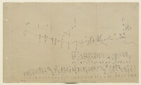
Sketch map of Pearl Banks between Koweit and Ras Tanura
IOR/R/15/5/91, f 11
2 items in this record
Search within this record
The record is made up of 1 map. It was created in Nov 1906. It was written in English and Arabic. The original is part of the British Library: India Office The department of the British Government to which the Government of India reported between 1858 and 1947. The successor to the Court of Directors. Records and Private Papers Documents collected in a private capacity. .
About this record
- Content
The map shows the locations of pearl banks along the east coast of the Persian Gulf The historical term used to describe the body of water between the Arabian Peninsula and Iran. between Kuwait and Ras Tanura. The map is a rough, hand-drawn sketch. The pearl banks are numbered from 1-58 which correspond to a numbered list (in Arabic) which appears on the sheet. Also given are the names of coastal features, towns, and islands. Accompanying the map (folios 12-13) is a second numbered list of pearl banks in the Gulf, most of which match that of the map. The map and lists were compiled by Major Stuart George Knox, Political Agent A mid-ranking political representative (equivalent to a Consul) from the diplomatic corps of the Government of India or one of its subordinate provincial governments, in charge of a Political Agency. , Kuwait, 'with the assistance of nakhoda [nakhuda] Saleh of the Koweit [Kuwait] pearlers'.
- Extent and format
- 1 map
- Area map covers
- Map loading...
- Scale
- 1:883452
- Scale designator
- Horizontal
- Orientation
- NNW
- Degree coordinates
- Top-left: 29° 26' 5.28" N, 47° 55' 40.44" E
Top-right: 29° 26' 5.28" N, 50° 10' 48.36" E
Bottom-left: 26° 2' 31.2" N, 47° 55' 40.44" E
Bottom-right: 26° 2' 31.2" N, 50° 10' 48.36" E - It is part of
- 78 imagesRef: IOR/R/15/5/91
- Physical characteristics
Materials: Manuscript; ink on paper
Dimensions: 560 x 332mm
- Written in
- English and Arabic in Latin and Arabic script
- Type
- Map
Archive information for this record
- Original held at
- British Library: India Office The department of the British Government to which the Government of India reported between 1858 and 1947. The successor to the Court of Directors. Records and Private Papers Documents collected in a private capacity.
- Access conditions
Unrestricted
- Archive reference
- IOR/R/15/5/91, f 11
- Date(s)
- Nov 1906 (CE, Gregorian)
Access & Reference
History of this record
Use and share this record
- Share this record
- Cite this record in your research
Sketch map of Pearl Banks between Koweit and Ras Tanura, British Library: India Office Records and Private Papers, IOR/R/15/5/91, f 11, in Qatar Digital Library <https://www.qdl.qa/archive/81055/vdc_100042853833.0x000001> [accessed 24 April 2024]
- Link to this record
https://www.qdl.qa/en/archive/81055/vdc_100042853833.0x000001
- IIIF details
This record has a IIIF manifest available as follows. If you have a compatible viewer you can drag the icon to load it.https://www.qdl.qa/en/iiif/81055/vdc_100000000831.0x000026/manifestOpen in Universal viewerOpen in Mirador viewerMore options for embedding images
Copyright: How to use this content
- Reference
- IOR/R/15/5/91, f 11
- Title
- Sketch map of Pearl Banks between Koweit and Ras Tanura
- Pages
- 11r:11v
- Author
- East India Company, the Board of Control, the India Office, or other British Government Department
- Usage terms
- Open Government Licence