![Coll 6/88 'Intelligence: Military Report on Arabia (C.B. 1892).' [‎18v] (41/133)](https://iiif.qdl.qa/iiif/images/81055/vdc_100000000555.0x0002bb/IOR_L_PS_12_2160B_0042.jp2/full/!1200,1200/0/default.jpg "Coll 6/88 'Intelligence: Military Report on Arabia (C.B. 1892).' [‎18v] (41/133)")
Coll 6/88 'Intelligence: Military Report on Arabia (C.B. 1892).' [18v] (41/133)
The record is made up of 1 file (63 folios). It was created in Feb 1932-7 Feb 1942. It was written in English. The original is part of the British Library: India Office The department of the British Government to which the Government of India reported between 1858 and 1947. The successor to the Court of Directors. Records and Private Papers Documents collected in a private capacity. .
Transcription
This transcription is created automatically. It may contain errors.
io
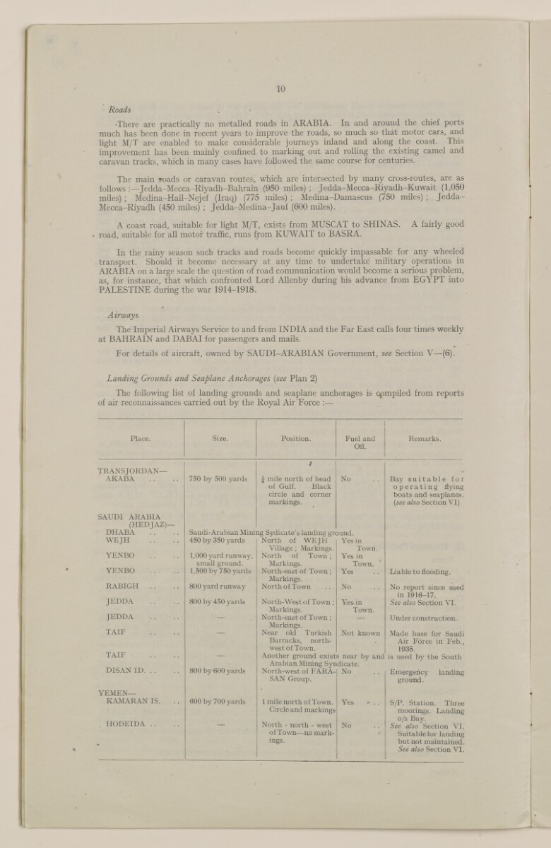
Roads
-There are practically no metalled roads in ARABIA. In and around the chief ports
much has been done in recent years to improve the roads, so much so that motor cars, and
light M/T are enabled to make considerable journeys inland and along the coast. This
improvement has been mainly confined to marking out and rolling the existing camel and
caravan tracks, which in many cases have followed the same course for centuries.
The main roads or caravan routes, which are intersected by many cross-routes, are as
follows :—Jedda-Mecca-Riyadh-Bahrain (950 miles) ; Jedda-Mecca-Riyadh-Kuwait (1,050
miles) ; Medina-Hail-Nejef (Iraq) (775 miles) ; Medina-Damascus (750 miles) ; Jedda-
Mecca-Riyadh (450 miles) ; Jedda-Medina-Jauf (600 miles).
A coast road, suitable for light M/T, exists from MUSCAT to SHINAS. A fairly good
• road, suitable for all motor traffic, runs from KUWAIT to BASRA.
In the rainy season such tracks and roads become quickly impassable for any wheeled
. transport. Should it become necessary at any time to undertake military operations in
ARABIA on a large scale the question of road communication would become a serious problem,
as, for instance, that which confronted Lord Allenby during his advance from EGYPT into
PALESTINE during the war 1914-1918.
* ’
Airways
The Imperial Airways Service to and from INDIA and the Far East calls four times weekly
at BAHRAIN and DABAI for passengers and mails.
For details of aircraft, owned by SAUDI-ARABIAN Government, see Section V—(6).
Landing Grounds and Seaplane Anchorages [see Plan 2)
The following list of landing grounds and seaplane anchorages is compiled from reports
of air reconnaissances carried out by the Royal Air Force :—
Place.
Size.
Position.
Fuel and
Remarks.
Oil.
TRANSJORDAN
Used in three contexts: the geographical region to the east of the River Jordan (literally ‘across the River Jordan’); a British protectorate (1921-46); an independent political entity (1946-49) now known as Jordan
'—
f
AKABA
750 by 500 yards
J mile north of head
No
Bay suitable for
of Gulf. Black
operating flying
circle and corner
boats and seaplanes.
markings.
{see also Section VI)
SAUDI ARABIA
(HEDJAZ)—
DHABA
Saudi-Arabian Mining Sydicate’s landing ground.
WEJH
450 by 350 yards
North of WEJH
Yes in
Village ; Markings.
Town.
YENBO
1,000 yard runway.
North of Town ;
Yes in
small ground.
Markings.
Town.
YENBO
1,500 by 750 yards
North-east of Town;
Yes
Liable to flooding.
Markings.
RABIGH . .
800 yard runway
North of Town
No
No report since used
in 1916-17.
JEDDA
800 by 450 yards
North-West of Town;
Yes in
See also Section VI.
Markings.
Town.
JEDDA
—
North-east of Town;
—
Under construction.
TAIF
Markings.
Near old Turkish
Not known
Made base for Saudi
Barracks, north-
, ■
Air Force in Feb,,
west of Town.
1935.
TAIF
—
Another ground exists near by and
is used by the South
DISAN ID
Arabian Mining Syndicate.
800 by 600 yards
North-west of FARA-
No
Emergency landing
SAN Group.
ground.
YEMEN—
*
KAMARAN IS.
600 by 700 yards
1 mile north of Town.
Yes - . .
S/P. Station. Three
Circle and markings
moorings. Landing
HODEIDA ..
—
North - north - west
No
o/s Bay.
See also Section VI.
of Town—no mark-
*
Suitable for landing
-
mgs.
but not maintained.
See also Section VI.
About this item
- Content
This file consists of two parts. The first part (folios 1-9) begins with a 'state of report' document for an Admiralty Naval Intelligence Division report entitled 'Arabia, Intelligence Report'; the 'state report' concerns the updating of the report in October 1941, and it includes a list of maps, plans and photographs that are contained in the report. There then follows a small amount of correspondence between India Office The department of the British Government to which the Government of India reported between 1858 and 1947. The successor to the Court of Directors. , War Office, and General Staff (India) officials regarding the supply of an earlier issue of the report, dated 1939.
The second part of the file consists of the actual report, entitled 'C.B. 1892 (X) (10/41) Arabia Intelligence Report', dated October 1941, with appended maps, plans and photographs relating to Arabian Peninsula ports. The report is divided into four sections (six sections are listed in the table of contents, which lists sections one and three, most of section two, and one part of section five, as 'not issued', i.e. not printed in this edition of the report).
The first section to appear in the report is entitled 'Section II: Strategy and Tactics'; parts 1 and 3-6 of this section have been omitted, leaving part 2, which has the heading 'Possible Lines on which War Plans would be Framed'.
The next section, 'Section IV: Geography and Topography', provides an overview of the geography and topography of the Arabian Peninsula, including information about climate, transport facilities (including a table of landing grounds and seaplane anchorages), and communications.
The third section, 'Section V: Base Facilities and Maintenance of the Fleet' (from which part one has been omitted), provides a summary of principal commercial dockyards and repair bases, locations for fuel storage, supplies and storage of ammunition, fixed coastal defences, and aircraft.
The final section of the report, 'Section VI: Ports, Anchorages and Their Defences', proceeds through a number of Gulf ports in alphabetical order (i.e. Akaba, Bahrain, Doha, Hodeida and Ras Kethib, Jedda, Kamaran, Kuwait, Mukalla, and Muscat), describing each place's port facilities, anchorages and defences, as well as providing other information relating to matters such as government, commerce, water supply, transport and communications.
Enclosed with the maps and plans is a symbols chart, which lists some of the symbols used in the maps and plans.
- Extent and format
- 1 file (63 folios)
- Arrangement
The Arabia Intelligence Report contains a table of contents. The maps, plans and photographs, which are listed below the table of contents, appear after the main text of the report.
- Physical characteristics
Foliation: The file is formed of two parts. The foliation sequence (used for referencing) commences at the front cover of the first part at 1 and terminates at the inside back cover of the second part at 65; these numbers are written in pencil, are circled, and are located in the top right corner of the recto The front of a sheet of paper or leaf, often abbreviated to 'r'. side of each folio.
- Written in
- English in Latin script View the complete information for this record
Use and share this item
- Share this item
Coll 6/88 'Intelligence: Military Report on Arabia (C.B. 1892).' [18v] (41/133), British Library: India Office Records and Private Papers, IOR/L/PS/12/2160B, in Qatar Digital Library <https://www.qdl.qa/archive/81055/vdc_100043097172.0x00002a> [accessed 19 April 2024]
https://www.qdl.qa/en/archive/81055/vdc_100043097172.0x00002a
Copy and paste the code below into your web page where you would like to embed the image.
<meta charset="utf-8"><a href="https://www.qdl.qa/en/archive/81055/vdc_100043097172.0x00002a">Coll 6/88 'Intelligence: Military Report on Arabia (C.B. 1892).' [‎18v] (41/133)</a> <a href="https://www.qdl.qa/en/archive/81055/vdc_100043097172.0x00002a"> <img src="https://iiif.qdl.qa/iiif/images/81055/vdc_100000000555.0x0002bb/IOR_L_PS_12_2160B_0042.jp2/full/!280,240/0/default.jpg" alt="" /> </a>
This record has a IIIF manifest available as follows. If you have a compatible viewer you can drag the icon to load it.https://www.qdl.qa/en/iiif/81055/vdc_100000000555.0x0002bb/manifestOpen in Universal viewerOpen in Mirador viewerMore options for embedding images
Copyright: How to use this content
- Reference
- IOR/L/PS/12/2160B
- Title
- Coll 6/88 'Intelligence: Military Report on Arabia (C.B. 1892).'
- Pages
- front, front-i, 2r:9v, front-a, back, spine, edge, head, tail, front-a-i, 11r:39v
- Author
- East India Company, the Board of Control, the India Office, or other British Government Department
- Usage terms
- Open Government Licence