Map Showing Anglo-Turkish Boundaries in the Arabian Peninsula
IOR/L/PS/12/2158, f 38

2 items in this record
Search within this record
The record is made up of 1 map. It was created in 1934. It was written in English. The original is part of the British Library: India Office The department of the British Government to which the Government of India reported between 1858 and 1947. The successor to the Court of Directors. Records and Private Papers Documents collected in a private capacity. .
About this record
- Content
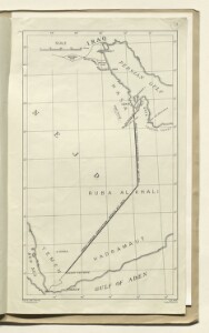
This map depicts two Anglo-Turkish boundaries in the Arabian Peninsula. The northernmost line represents the 'blue line', which was laid down in the non-ratified Anglo-Ottoman Convention of 1913 and redefined and adopted in the Anglo-Ottoman convention of the following year. The line that descends south-west from the blue line is the 'violet line', which was laid down in the Anglo-Ottoman convention of 1914.
- Extent and format
- 1 map
- Area map covers
- Map loading...
- Scale
- 1:6,985,000 approximately
- Scale designator
- Horizontal
- Orientation
- North
- Degree coordinates
- Top-left: 30° 0' 0" N, 42° 47' 60" E
Top-right: 30° 0' 0" N, 52° 32' 24" E
Bottom-left: 12° 28' 48" N, 42° 47' 60" E
Bottom-right: 12° 28' 48" N, 52° 32' 24" E - It is part of
- 80 imagesRef: IOR/L/PS/12/2158
- Physical characteristics
Materials: Printed on paper.
Dimensions 303 x 174mm, on sheet 334 x 200mm.
- Written in
- English in Latin script
- Type
- Map
Archive information for this record
- Original held at
- British Library: India Office The department of the British Government to which the Government of India reported between 1858 and 1947. The successor to the Court of Directors. Records and Private Papers Documents collected in a private capacity.
- Access conditions
Unrestricted
- Archive reference
- IOR/L/PS/12/2158, f 38
- Date(s)
- 1934 (CE, Gregorian)
Access & Reference
History of this record
Related search terms
- Places
- Palestine
Use and share this record
- Share this record
- Cite this record in your research
Map Showing Anglo-Turkish Boundaries in the Arabian Peninsula, British Library: India Office Records and Private Papers, IOR/L/PS/12/2158, f 38, in Qatar Digital Library <https://www.qdl.qa/archive/81055/vdc_100045726259.0x000001> [accessed 20 April 2024]
- Link to this record
https://www.qdl.qa/en/archive/81055/vdc_100045726259.0x000001
- IIIF details
This record has a IIIF manifest available as follows. If you have a compatible viewer you can drag the icon to load it.https://www.qdl.qa/en/iiif/81055/vdc_100000000555.0x0002b8/manifestOpen in Universal viewerOpen in Mirador viewerMore options for embedding images
Copyright: How to use this content
- Reference
- IOR/L/PS/12/2158, f 38
- Title
- Map Showing Anglo-Turkish Boundaries in the Arabian Peninsula
- Pages
- 38r:38v
- Author
- East India Company, the Board of Control, the India Office, or other British Government Department
- Usage terms
- Open Government Licence