'MAP TO SHOW THE LIMITS OF KOWEIT AND ADJACENT COUNTRY'
IOR/L/PS/10/60 (vi)

2 items in this record
Search within this record
The record is made up of 1 map. It was created in 1912. It was written in English. The original is part of the British Library: India Office The department of the British Government to which the Government of India reported between 1858 and 1947. The successor to the Court of Directors. Records and Private Papers Documents collected in a private capacity. .
About this record
- Content
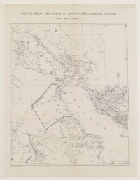
Map depicting the limits of Kuwait and surrounding region. The scale is stated underneath the title as being '1 inch = 48 miles'. The map indicates settlements, hydrology, and boundaries, and provides some indication of relief. The map features an additional line marked in black ink, which represents a possible boundary line for Kuwait.
- Extent and format
- 1 map
- Area map covers
- Map loading...
- Orientation
- North
- Degree coordinates
- Top-left: 31° 26' 60" N, 46° 32' 60" E
Top-right: 31° 26' 60" N, 53° 5' 24" E
Bottom-left: 23° 55' 48" N, 46° 32' 60" E
Bottom-right: 23° 55' 48" N, 53° 5' 24" E - It is part of
- 536 imagesRef: IOR/L/PS/10/60
- Physical characteristics
Materials: Printed in colour on paper
Dimensions: 400 x 330mm, on sheet 480 x 370mm
- Written in
- English in Latin script
- Type
- Map
Archive information for this record
- Original held at
- British Library: India Office The department of the British Government to which the Government of India reported between 1858 and 1947. The successor to the Court of Directors. Records and Private Papers Documents collected in a private capacity.
- Access conditions
Unrestricted
- Archive reference
- IOR/L/PS/10/60 (vi)
- Former external reference(s)
- (4 7/12.2148) F.O.830
- Date(s)
- 1912 (CE, Gregorian)
Access & Reference
History of this record
Use and share this record
- Share this record
- Cite this record in your research
'MAP TO SHOW THE LIMITS OF KOWEIT AND ADJACENT COUNTRY', British Library: India Office Records and Private Papers, IOR/L/PS/10/60 (vi), in Qatar Digital Library <https://www.qdl.qa/archive/81055/vdc_100048656965.0x000006> [accessed 25 April 2024]
- Link to this record
https://www.qdl.qa/en/archive/81055/vdc_100048656965.0x000006
- IIIF details
This record has a IIIF manifest available as follows. If you have a compatible viewer you can drag the icon to load it.https://www.qdl.qa/en/iiif/81055/vdc_100000000365.0x000391/manifestOpen in Universal viewerOpen in Mirador viewerMore options for embedding images
Copyright: How to use this content
- Reference
- IOR/L/PS/10/60 (vi)
- Title
- 'MAP TO SHOW THE LIMITS OF KOWEIT AND ADJACENT COUNTRY'
- Pages
- 189ar:189av
- Author
- East India Company, the Board of Control, the India Office, or other British Government Department
- Usage terms
- Open Government Licence