![‘Military report on south-west Persia, including the provinces of Khúzistán (Arabistan), Luristán and part of Fars.’ [‎116r] (236/470)](https://iiif.qdl.qa/iiif/images/81055/vdc_100000000239.0x00012f/IOR_L_MIL_17_15_9_0258.jp2/full/!1200,1200/0/default.jpg "‘Military report on south-west Persia, including the provinces of Khúzistán (Arabistan), Luristán and part of Fars.’ [‎116r] (236/470)")
‘Military report on south-west Persia, including the provinces of Khúzistán (Arabistan), Luristán and part of Fars.’ [116r] (236/470)
The record is made up of 1 volume (231 folios). It was created in 1885. It was written in English. The original is part of the British Library: India Office The department of the British Government to which the Government of India reported between 1858 and 1947. The successor to the Court of Directors. Records and Private Papers Documents collected in a private capacity. .
Transcription
This transcription is created automatically. It may contain errors.
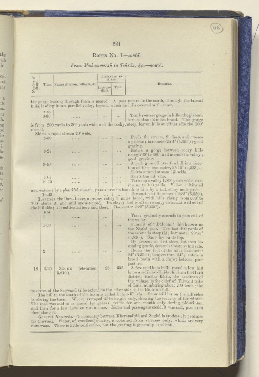
Route No. 1 — contd.
From Muhammerah to Tehran, 8fc .—contd
Distances in
^ A*
MILES.
% *
gB
a 32
>5
Time.
Names of towns, villages, &c.
Interme-
Total.
Remarks.
diate.
the gorge loading through them is neared. A pass occurs to the south, through the lateral
hills, leadirg into a parallel valley, beyoud which lie hills covered with snow.
Tomb ; enters gorge in hills; the plateau
here is about 2 miles broad. The gorge
A.M.
8-30
...
8-50
...
9-25
...
9-40
...
10-5
10-15
...
1-30
over it.
Skirts a rapid stream 20' wide.
Fords the stream, 2' deep, and crosses
a plateau ; barometer 25 , 4" (4,690'); good
grazing.
Enters a gorge between rocky hills
rising 200' to 400', and ascends its valley ;
good grazing.
A path goes off over the hill in a dii'ec-
tion of 40°; barometer, 25T5'' (4,923').
Skirts a rapid stream 15' wide.
Skirts the hill side.
Turns up a valley 1,000 yards wide, nar
rowing to 100 yards. Valley cultivated
and watered by a plentiful stream ; passes over its bounding hills by a had, stony mule path.
| 10-45 | I ••• I ••• I Barometer at its summit 24'5" (5,650').
Traverses the Dara-Daiuz, a grassy valley 7 miles broad, with hills rising from 500'to
7 () 0 ' above it, and still snow-topped. Its clayey bed is often swampy ; streams well out of
the hill side; it is cultivated here and there. Barometer 24 , 5' / (5,650').
P.M.
Track gradually ascends to pass out of
the valley
Summit of “Buhihan” hill known as
the Zaghe pass. The last 4< >0 yards of
the ascent is steep (j); barometer 23‘55"
(6,830'). Snow lay on its top.
By descent at first steep, but soon be-
cominggentle, descends the stony hill side.
Reach the foot of the hill ; barometer
24" (6,330') ; temperature 64° ; enters a
broad basin with a clayey bottom; poor
pasture.
A few mud huts built round a low hill
known asKala-i-HaidarKhanin theHuru
district. Haidar Khan, the headman of
the village, is the chief of Talwant tribe
of Lurs, numbering about 200 tents ; the
pastures of the Sagwand tribe extend to the other side of the Buluhan hill.
The hill to tile south of the basin is called Charlo Khiyia. Snow still lay on the hill sides
bordering the basin. Wheat averaged 2" in height only, showing the severity of the winter.
The road was said to be closed for general traffic for one month only during mid-winter,
and then for a few days only at a time. Mules and passengers could, it was said, pass even
then along it.
General Remarlcs. —The country between Khoramabad and Zaghe is treeless ; it produces
no firewood. Water, of excellent quality, is obtained from streams only, which are very
numerous. There is little cultivation, but the grazing is generally excellent.
18
2-20
Zaghe
5,910').
('elevation
22
352
About this item
- Content
Report marked strictly confidential, prepared in the Intelligence Branch of the Quarter Master General’s Department in India, by the Assistant Quarter Master General, Major and Brevet Lieutenant-Colonel Mark Sever Bell, Royal Engineers. The volume was published by the Government Central Branch Press, Simla, 1885.
The contents of the volume are as follows:
- part I, a narrative description of a journey from India to Muhammerah [Khorramshahr], through to the Luristán [Lorestān] hills, to Kúm [Qom]; from Kúm to Gulpaigán [Golpāyegān ], Chaman-i-Sultán [Chaman Solţān], Ali-Gúdar [Alīgūdarz], Imámzádá-Ishmail [Emāmzādeh Esmā‘īl], and the Zaindarúd River [Zāyandeh Rūd] to Isfahán; from Isfahán through the Kúhgehlú [Kohgīlūyeh] hills to Behbahán and Bandar-Dilám [Bandar-e Deylam]; from Bandar-Dilám to Bushire
- part II, a detailed account of southwest Persia, compiled from Sever’s own observations and other available sources
- part III, commercial considerations. A further section in this chapter on strategic observations, which is mentioned on the contents page and marked as secret, is not present in the volume
- part IV, detailed road reports
- appendix A, road reports, Isfahan to Shústar [Shūshtar], Shústar to Shíráz [Shīrāz], compiled in 1881 by Captain Henry Lake Wells, Assistant Director of Persian Telegraphs, with additional annotations by Bell
- appendix B, a list of plant specimens collected in Luristán during April and May 1884
- appendix C, extracts of a paper on the geology of the Turko-Persian frontier, written by William Kennett Loftus, June 1854
- appendix D, meteorological observations at Bushire, from 20 March to 20 June 1885
The volume includes eight maps, two photographic plates, and illustrations throughout (topographical, architectural, anthropological). The two photographic plates and some of the maps are of an earlier date than the volume’s publication date of 1885.
- Extent and format
- 1 volume (231 folios)
- Arrangement
A contents page (f 7) and index (ff 222-226) refer to the volume’s original printed pagination.
- Physical characteristics
Foliation: the foliation sequence (used for referencing) commences at the front cover with 1, and terminates at the inside back cover with 233; these numbers are written in pencil, are circled, and are located in the top right corner of the recto The front of a sheet of paper or leaf, often abbreviated to 'r'. side of each folio.
Pagination: the file also contains an original printed pagination sequence.
- Written in
- English in Latin script View the complete information for this record
Use and share this item
- Share this item
‘Military report on south-west Persia, including the provinces of Khúzistán (Arabistan), Luristán and part of Fars.’ [116r] (236/470), British Library: India Office Records and Private Papers, IOR/L/MIL/17/15/9, in Qatar Digital Library <https://www.qdl.qa/archive/81055/vdc_100048990083.0x000025> [accessed 19 April 2024]
https://www.qdl.qa/en/archive/81055/vdc_100048990083.0x000025
Copy and paste the code below into your web page where you would like to embed the image.
<meta charset="utf-8"><a href="https://www.qdl.qa/en/archive/81055/vdc_100048990083.0x000025">‘Military report on south-west Persia, including the provinces of Khúzistán (Arabistan), Luristán and part of Fars.’ [‎116r] (236/470)</a> <a href="https://www.qdl.qa/en/archive/81055/vdc_100048990083.0x000025"> <img src="https://iiif.qdl.qa/iiif/images/81055/vdc_100000000239.0x00012f/IOR_L_MIL_17_15_9_0258.jp2/full/!280,240/0/default.jpg" alt="" /> </a>
This record has a IIIF manifest available as follows. If you have a compatible viewer you can drag the icon to load it.https://www.qdl.qa/en/iiif/81055/vdc_100000000239.0x00012f/manifestOpen in Universal viewerOpen in Mirador viewerMore options for embedding images
Copyright: How to use this content
- Reference
- IOR/L/MIL/17/15/9
- Title
- ‘Military report on south-west Persia, including the provinces of Khúzistán (Arabistan), Luristán and part of Fars.’
- Pages
- front, back, spine, edge, head, tail, front-i, 2r:11v, 13r:62v, 64r:82v, 84r:88v, 90r:95v, 97r:190v, 210r:228v, back-i
- Author
- East India Company, the Board of Control, the India Office, or other British Government Department
- Usage terms
- Open Government Licence