![Sketch map of Bahrain Island [‎59r] (1/2)](https://iiif.qdl.qa/iiif/images/81055/vdc_100000000555.0x000247/IOR_L_PS_12_2045_0120.jp2/full/!1200,1200/0/default.jpg "Sketch map of Bahrain Island [‎59r] (1/2)")
Sketch map of Bahrain Island [59r] (1/2)
The record is made up of 1 map. It was created in 22 Jan 1945. It was written in English. The original is part of the British Library: India Office The department of the British Government to which the Government of India reported between 1858 and 1947. The successor to the Court of Directors. Records and Private Papers Documents collected in a private capacity. .
About this item
- Content
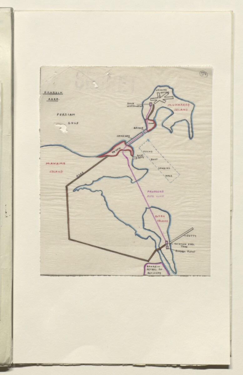
The map is appended to an agenda for a meeting, held at the Air Ministry at 11:00am on 25 January 1945, to discuss the provision of further aviation refuelling facilities at Bahrain in the form of tankage and a pipeline: see folio 58 for the agenda and folio 60-61 for the minutes.
The proposed pipeline between the jetty on Sitra Island and the landing ground at Muharraq Island is highlighted in pink. The location of Manama, the Bahrain Petroleum Company's (BAPCO's) refinery, and the flying boat landing area are also marked on the map.
- Extent and format
- 1 map
- Area map covers
- Map loading...
- Scale
- No scale given
- Scale designator
- Horizontal
- Orientation
- North
- Degree coordinates
- Top-left: 26° 17' 54.02" N, 50° 32' 53.15" E
Top-right: 26° 17' 54.02" N, 50° 41' 19.89" E
Bottom-left: 26° 6' 10.94" N, 50° 32' 53.15" E
Bottom-right: 26° 6' 10.94" N, 50° 41' 19.89" E - Physical characteristics
Dimensions: 195 x 160mm
Materials: Manuscript; ink on paper
- Written in
- English in Latin script View the complete information for this record
Use and share this item
- Share this item
Sketch map of Bahrain Island [59r] (1/2), British Library: India Office Records and Private Papers, IOR/L/PS/12/2045, f 59, in Qatar Digital Library <https://www.qdl.qa/archive/81055/vdc_100049676104.0x000078> [accessed 19 April 2024]
https://www.qdl.qa/en/archive/81055/vdc_100049676104.0x000078
Copy and paste the code below into your web page where you would like to embed the image.
<meta charset="utf-8"><a href="https://www.qdl.qa/en/archive/81055/vdc_100049676104.0x000078">Sketch map of Bahrain Island [‎59r] (1/2)</a> <a href="https://www.qdl.qa/en/archive/81055/vdc_100049676104.0x000078"> <img src="https://iiif.qdl.qa/iiif/images/81055/vdc_100000000555.0x000247/IOR_L_PS_12_2045_0120.jp2/full/!280,240/0/default.jpg" alt="" /> </a>
This record has a IIIF manifest available as follows. If you have a compatible viewer you can drag the icon to load it.https://www.qdl.qa/en/iiif/81055/vdc_100000000555.0x000247/manifestOpen in Universal viewerOpen in Mirador viewerMore options for embedding images
Copyright: How to use this content
- Reference
- IOR/L/PS/12/2045, f 59
- Title
- Sketch map of Bahrain Island
- Pages
- 59r
- Author
- East India Company, the Board of Control, the India Office, or other British Government Department
- Usage terms
- Public Domain