![Sketch Map of the Eastern Arabian Peninsula [‎274r] (1/2)](https://iiif.qdl.qa/iiif/images/81055/vdc_100000000555.0x0002a1/IOR_L_PS_12_2135_0558.jp2/full/!1200,1200/0/default.jpg "Sketch Map of the Eastern Arabian Peninsula [‎274r] (1/2)")
Sketch Map of the Eastern Arabian Peninsula [274r] (1/2)
The record is made up of 1 map. It was created in 1934. It was written in English. The original is part of the British Library: India Office The department of the British Government to which the Government of India reported between 1858 and 1947. The successor to the Court of Directors. Records and Private Papers Documents collected in a private capacity. .
About this item
- Content
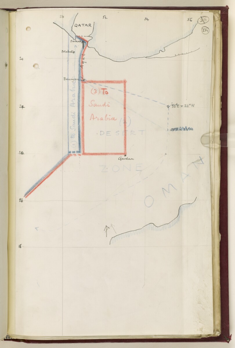
Map depicting the eastern Arabian Peninsula. The map, which was prepared in anticipation of frontier negotiations with the Saudi Arabian Government, shows possible lines for the south-eastern Saudi Arabian border, as proposed by the Foreign Office.
A blue line, drawn in blue crayon and descending from slightly west of Qatar, represents the 'blue line', a boundary line agreed between the British Government and the Ottoman Empire in the Anglo-Ottoman Convention (1913). A second blue line further to the east represents one possible boundary. A third line, drawn in red crayon, shows another possible concession; this line includes a portion of a larger 'desert zone'.
- Extent and format
- 1 map
- Area map covers
- Map loading...
- Scale
- No scale given.
- Scale designator
- Horizontal
- Orientation
- North
- Degree coordinates
- Top-left: 25° 46' 48" N, 49° 32' 60" E
Top-right: 25° 46' 48" N, 56° 13' 12" E
Bottom-left: 17° 11' 24" N, 49° 32' 60" E
Bottom-right: 17° 11' 24" N, 56° 13' 12" E - Physical characteristics
Materials: Manuscript; black ink and crayon on paper.
Dimensions: 328 x 204mm.
- Written in
- English in Latin script View the complete information for this record
Use and share this item
- Share this item
Sketch Map of the Eastern Arabian Peninsula [274r] (1/2), British Library: India Office Records and Private Papers, IOR/L/PS/12/2135, f 274, in Qatar Digital Library <https://www.qdl.qa/archive/81055/vdc_100054083085.0x000099> [accessed 18 April 2024]
https://www.qdl.qa/en/archive/81055/vdc_100054083085.0x000099
Copy and paste the code below into your web page where you would like to embed the image.
<meta charset="utf-8"><a href="https://www.qdl.qa/en/archive/81055/vdc_100054083085.0x000099">Sketch Map of the Eastern Arabian Peninsula [‎274r] (1/2)</a> <a href="https://www.qdl.qa/en/archive/81055/vdc_100054083085.0x000099"> <img src="https://iiif.qdl.qa/iiif/images/81055/vdc_100000000555.0x0002a1/IOR_L_PS_12_2135_0558.jp2/full/!280,240/0/default.jpg" alt="" /> </a>
This record has a IIIF manifest available as follows. If you have a compatible viewer you can drag the icon to load it.https://www.qdl.qa/en/iiif/81055/vdc_100000000555.0x0002a1/manifestOpen in Universal viewerOpen in Mirador viewerMore options for embedding images
Copyright: How to use this content
- Reference
- IOR/L/PS/12/2135, f 274
- Title
- Sketch Map of the Eastern Arabian Peninsula
- Pages
- 274r
- Author
- East India Company, the Board of Control, the India Office, or other British Government Department
- Usage terms
- Public Domain