Outline map showing boundaries in Arabia
IOR/R/15/1/630, f 24


2 items in this record
Search within this record
The record is made up of 1 map. It was created in Apr 1934. It was written in English. The original is part of the British Library: India Office The department of the British Government to which the Government of India reported between 1858 and 1947. The successor to the Court of Directors. Records and Private Papers Documents collected in a private capacity. .
About this record
- Content
Imprint:
Malby & Sons Lith.
Distinctive Features:
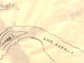
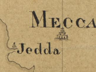
Issued by Foreign Office as an annex to ‘Memorandum respecting the Boundaries in Arabia: Anglo-Turkish Arrangements' (E 723/723/91). Map shows frontiers laid down in the Anglo-Turkish Conventions of 1913 and 1914; a neutral zone limits determined in Nejd-Koweit agreement of 1922; and a Nejd-Qatar boundary marked by Sir Percy Cox in his discussions with Ibn Saud in 1922.
- Extent and format
- 1 map
- Area map covers
- Map loading...
- Scale
- Scale approximately 1:7,000,000
- Scale designator
- Horizontal
- Orientation
- North
- Degree coordinates
- Top-left: 30° 21' 0" N, 42° 4' 12" E
Top-right: 30° 21' 0" N, 53° 1' 48" E
Bottom-left: 12° 21' 36" N, 42° 4' 12" E
Bottom-right: 12° 21' 36" N, 53° 1' 48" E - It is part of
- 466 imagesRef: IOR/R/15/1/630
- Physical characteristics
Dimensions:
291 x 164 mm, on sheet 326 x 180 mm
- Written in
- English in Latin script
- Type
- Map
Archive information for this record
- Original held at
- British Library: India Office The department of the British Government to which the Government of India reported between 1858 and 1947. The successor to the Court of Directors. Records and Private Papers Documents collected in a private capacity.
- Access conditions
Unrestricted
- Archive reference
- IOR/R/15/1/630, f 24
- Date(s)
- Apr 1934 (CE, Gregorian)
Access & Reference
History of this record
Related search terms
- Places
- Arabian Peninsula
Use and share this record
- Share this record
- Cite this record in your research
Outline map showing boundaries in Arabia, British Library: India Office Records and Private Papers, IOR/R/15/1/630, f 24, in Qatar Digital Library <https://www.qdl.qa/archive/81055/vdc_100055623539.0x000003> [accessed 19 April 2024]
- Link to this record
https://www.qdl.qa/en/archive/81055/vdc_100055623539.0x000003
- IIIF details
This record has a IIIF manifest available as follows. If you have a compatible viewer you can drag the icon to load it.https://www.qdl.qa/en/iiif/81055/vdc_100000000193.0x00025c/manifestOpen in Universal viewerOpen in Mirador viewerMore options for embedding images
Copyright: How to use this content
- Reference
- IOR/R/15/1/630, f 24
- Title
- Outline map showing boundaries in Arabia
- Pages
- 24r:24v
- Author
- Malby and Sons
- Usage terms
- The copyright status is unknown. Please contact copyright@bl.uk with any information you have regarding this item.