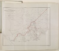
‘Map showing TRIBES AND NEW BOUNDARY OF THE ADEN PROTECTORATE’
IOR/L/PS/10/407, f 93

2 items in this record
Search within this record
The record is made up of 1 map. It was created in 1906. It was written in English. The original is part of the British Library: India Office The department of the British Government to which the Government of India reported between 1858 and 1947. The successor to the Court of Directors. Records and Private Papers Documents collected in a private capacity. .
About this record
- Content
A printed map showing the Aden Protectorate frontier or boundary, which is drawn as a thick red line. The map gives the names of the tribes and sub-tribes inhabiting country within the Protectorate boundary, with approximate tribal boundaries drawn as a thin red line. Telegraph lines are also shown, including the submarine telegraph cable lines along the Arabian coast towards Karachi. This copy map is included in correspondence about the Aden Boundary Settlement of 1905, and in particular, the descriptions of tribal boundaries submitted by Colonel R A Wahab, the British boundary commissioner, 1903-1905. The map bears the printing statements: ‘Topographical Section, General Staff. No. 2124’, and ‘War Office Jan. 1906’.
- Extent and format
- 1 map
- Area map covers
- Map loading...
- Scale
- Scale: 1:633,600
- Scale designator
- Horizontal
- Orientation
- North
- Degree coordinates
- Top-left: 15° 1' 18.12" N, 42° 38' 56.04" E
Top-right: 15° 1' 18.12" N, 48° 0' 37.08" E
Bottom-left: 12° 1' 42.96" N, 42° 38' 56.04" E
Bottom-right: 12° 1' 42.96" N, 48° 0' 37.08" E - It is part of
- 268 imagesRef: IOR/L/PS/10/407
- Physical characteristics
Materials: printed in colour on paper. Dimensions: 410 x 505mm, on sheet 500 x 610mm.
- Written in
- English in Latin script
- Type
- Map
Archive information for this record
- Original held at
- British Library: India Office The department of the British Government to which the Government of India reported between 1858 and 1947. The successor to the Court of Directors. Records and Private Papers Documents collected in a private capacity.
- Access conditions
Unrestricted
- Archive reference
- IOR/L/PS/10/407, f 93
- Date(s)
- 1906 (CE, Gregorian)
Access & Reference
History of this record
Use and share this record
- Share this record
- Cite this record in your research
‘Map showing TRIBES AND NEW BOUNDARY OF THE ADEN PROTECTORATE’, British Library: India Office Records and Private Papers, IOR/L/PS/10/407, f 93, in Qatar Digital Library <https://www.qdl.qa/archive/81055/vdc_100055644130.0x000001> [accessed 16 April 2024]
- Link to this record
https://www.qdl.qa/en/archive/81055/vdc_100055644130.0x000001
- IIIF details
This record has a IIIF manifest available as follows. If you have a compatible viewer you can drag the icon to load it.https://www.qdl.qa/en/iiif/81055/vdc_100000000419.0x00012e/manifestOpen in Universal viewerOpen in Mirador viewerMore options for embedding images
Copyright: How to use this content
- Reference
- IOR/L/PS/10/407, f 93
- Title
- ‘Map showing TRIBES AND NEW BOUNDARY OF THE ADEN PROTECTORATE’
- Pages
- 93r:93v
- Author
- East India Company, the Board of Control, the India Office, or other British Government Department
- Usage terms
- Open Government Licence