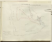
'APPENDIX C. MAP SHOWING THE EXTENT OF WAHABI AND OF MUSCAT POWER, 1865.'
IOR/L/PS/12/2134, f 200
2 items in this record
Search within this record
The record is made up of 1 map. It was created in 26 Sep 1934. It was written in English. The original is part of the British Library: India Office The department of the British Government to which the Government of India reported between 1858 and 1947. The successor to the Court of Directors. Records and Private Papers Documents collected in a private capacity. .
About this record
- Content
Map enclosed as an appendix to an India Office The department of the British Government to which the Government of India reported between 1858 and 1947. The successor to the Court of Directors. memorandum entitled 'Historical Memorandum on the Relations of the Wahabi Amirs and Ibn Saud with Eastern Arabia and the British Government, 1800-1934', dated 26 September 1934. The map depicts the south-eastern part of the Arabian Peninsula, with the Red Sea and the Persian Gulf The historical term used to describe the body of water between the Arabian Peninsula and Iran. on either side. Red and blue lines, which are referenced in a corresponding key, outline the respective areas of Wahabee [Wahabi] and Muscat power.
- Extent and format
- 1 map
- Area map covers
- Map loading...
- Scale
- Scale not given
- Scale designator
- Horizontal
- Orientation
- North
- Degree coordinates
- Top-left: 27° 3' 0" N, 37° 6' 36" E
Top-right: 27° 3' 0" N, 60° 22' 48" E
Bottom-left: 12° 25' 12" N, 37° 6' 36" E
Bottom-right: 12° 25' 12" N, 60° 22' 48" E - It is part of
- 794 imagesRef: IOR/L/PS/12/2134
- Physical characteristics
Materials: Printed in colour on paper.
Dimensions: 333 x 420mm.
- Written in
- English in Latin script
- Type
- Map
Archive information for this record
- Original held at
- British Library: India Office The department of the British Government to which the Government of India reported between 1858 and 1947. The successor to the Court of Directors. Records and Private Papers Documents collected in a private capacity.
- Access conditions
Unrestricted
- Archive reference
- IOR/L/PS/12/2134, f 200
- Date(s)
- 26 Sep 1934 (CE, Gregorian)
Access & Reference
History of this record
Use and share this record
- Share this record
- Cite this record in your research
'APPENDIX C. MAP SHOWING THE EXTENT OF WAHABI AND OF MUSCAT POWER, 1865.', British Library: India Office Records and Private Papers, IOR/L/PS/12/2134, f 200, in Qatar Digital Library <https://www.qdl.qa/archive/81055/vdc_100056602090.0x000001> [accessed 18 April 2024]
- Link to this record
https://www.qdl.qa/en/archive/81055/vdc_100056602090.0x000001
- IIIF details
This record has a IIIF manifest available as follows. If you have a compatible viewer you can drag the icon to load it.https://www.qdl.qa/en/iiif/81055/vdc_100000000555.0x0002a0/manifestOpen in Universal viewerOpen in Mirador viewerMore options for embedding images
Copyright: How to use this content
- Reference
- IOR/L/PS/12/2134, f 200
- Title
- 'APPENDIX C. MAP SHOWING THE EXTENT OF WAHABI AND OF MUSCAT POWER, 1865.'
- Pages
- 200r:200v
- Author
- East India Company, the Board of Control, the India Office, or other British Government Department
- Usage terms
- Open Government Licence