!['APPROXIMATE BOUNDARIES OF JOWASIM TRIBE AND PART BINI YAS TERRITORIES.' [‎118r] (1/2)](https://iiif.qdl.qa/iiif/images/81055/vdc_100000000648.0x0001d7/IOR_L_PS_12_3901_0244.jp2/full/!1200,1200/0/default.jpg "'APPROXIMATE BOUNDARIES OF JOWASIM TRIBE AND PART BINI YAS TERRITORIES.' [‎118r] (1/2)")
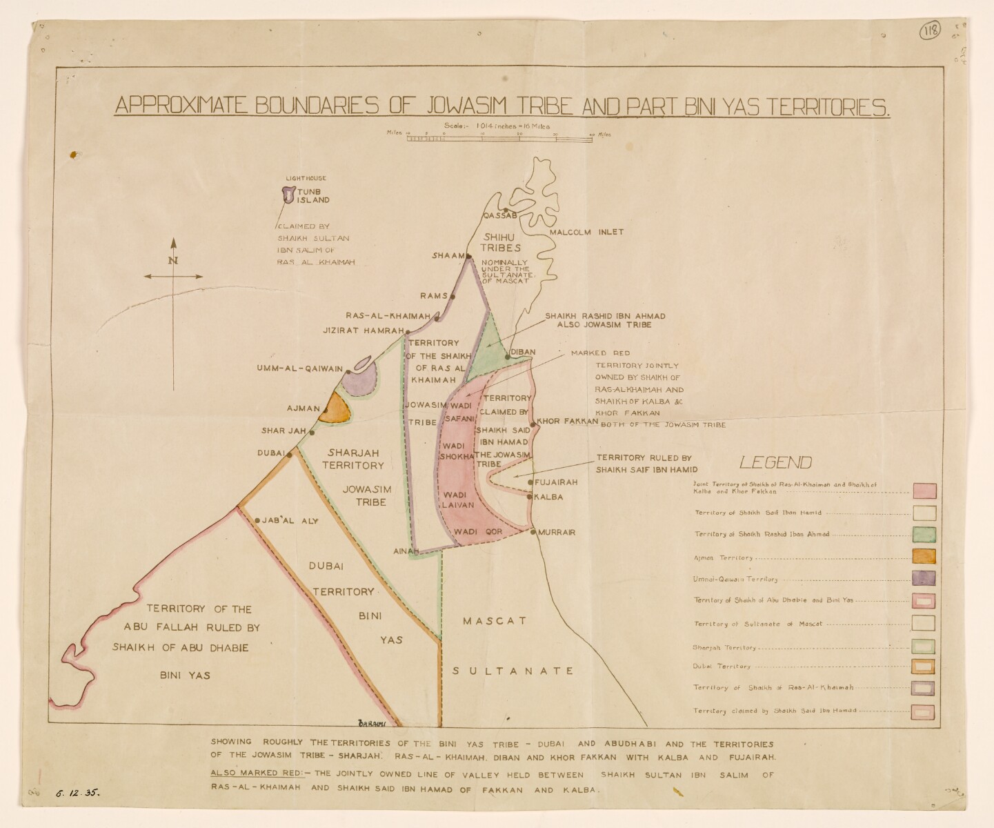
'APPROXIMATE BOUNDARIES OF JOWASIM TRIBE AND PART BINI YAS TERRITORIES.' [118r] (1/2)
The record is made up of 1 map. It was created in 6 Dec 1935. It was written in English. The original is part of the British Library: India Office The department of the British Government to which the Government of India reported between 1858 and 1947. The successor to the Court of Directors. Records and Private Papers Documents collected in a private capacity. .
About this item
- Content
This sketch map shows the boundaries of the Jowasim [ Qawasim One of the ruling families of the United Arab Emirates; also used to refer to a confederation of seafaring Arabs led by the Qāsimī tribe from Ras al Khaima. ] tribe and part of the territories of the Bini Yas [Bani Yas] tribe in the Trucial Coast A name used by Britain from the nineteenth century to 1971 to refer to the present-day United Arab Emirates. .
The map shows the Trucial Coast A name used by Britain from the nineteenth century to 1971 to refer to the present-day United Arab Emirates. 's main settlements, the island of Tunb, and parts of Mascat [the Sultanate of Muscat and Oman].
The various territories are delineated either by dotted lines edged in different colours, or by dotted lines enclosing territory filled in with a single colour. The colour coding of the various territories is also explained in a key in the bottom right hand corner of the map. A note beneath the map summarises the main purpose and divisions of the map, and states that a certain area jointly owned by the rulers of Ras-al Khaimah and Kalba is also marked in red.
- Extent and format
- 1 map
- Area map covers
- Map loading...
- Scale
- Scale approximately 1:1,071,821
- Scale designator
- Horizontal
- Orientation
- North
- Degree coordinates
- Top-left: 26° 23' 21.84" N, 54° 33' 48.96" E
Top-right: 26° 23' 21.84" N, 56° 47' 37.68" E
Bottom-left: 24° 20' 49.56" N, 54° 33' 48.96" E
Bottom-right: 24° 20' 49.56" N, 56° 47' 37.68" E - Physical characteristics
Materials: printed on paper.
Dimensions: 335 x 400mm
- Written in
- English in Latin script View the complete information for this record
Use and share this item
- Share this item
'APPROXIMATE BOUNDARIES OF JOWASIM TRIBE AND PART BINI YAS TERRITORIES.' [118r] (1/2), British Library: India Office Records and Private Papers, IOR/L/PS/12/3901, f 118, in Qatar Digital Library <https://www.qdl.qa/archive/81055/vdc_100058762142.0x000029> [accessed 25 April 2024]
https://www.qdl.qa/en/archive/81055/vdc_100058762142.0x000029
Copy and paste the code below into your web page where you would like to embed the image.
<meta charset="utf-8"><a href="https://www.qdl.qa/en/archive/81055/vdc_100058762142.0x000029">'APPROXIMATE BOUNDARIES OF JOWASIM TRIBE AND PART BINI YAS TERRITORIES.' [‎118r] (1/2)</a> <a href="https://www.qdl.qa/en/archive/81055/vdc_100058762142.0x000029"> <img src="https://iiif.qdl.qa/iiif/images/81055/vdc_100000000648.0x0001d7/IOR_L_PS_12_3901_0244.jp2/full/!280,240/0/default.jpg" alt="" /> </a>
This record has a IIIF manifest available as follows. If you have a compatible viewer you can drag the icon to load it.https://www.qdl.qa/en/iiif/81055/vdc_100000000648.0x0001d7/manifestOpen in Universal viewerOpen in Mirador viewerMore options for embedding images
Copyright: How to use this content
- Reference
- IOR/L/PS/12/3901, f 118
- Title
- 'APPROXIMATE BOUNDARIES OF JOWASIM TRIBE AND PART BINI YAS TERRITORIES.'
- Pages
- 118r:118v
- Author
- Unknown
- Usage terms
- The copyright status is unknown. Please contact copyright@bl.uk with any information you have regarding this item.