Map of the Trucial Coast
IOR/L/PS/12/3901, f 119

2 items in this record
Search within this record
The record is made up of 1 map. It was created in c 1938. It was written in English. The original is part of the British Library: India Office The department of the British Government to which the Government of India reported between 1858 and 1947. The successor to the Court of Directors. Records and Private Papers Documents collected in a private capacity. .
About this record
- Content
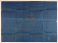
Blueprint sketch map of the Trucial Coast A name used by Britain from the nineteenth century to 1971 to refer to the present-day United Arab Emirates. , showing the territories of Ras-al-Khaimah, Umm-al-Qaiwain, Ajman, Sharjah, Dabei [Dubai], and Abu Dhabi.
The various territories are delineated by means of white dotted lines, coloured infill, or shading, or by being left blank. A key to the various territories appears in the bottom right hand corner of the map.
Certain islands, and lines of latitude and longitude are shown. There is also some indication of hydrology and relief.
- Extent and format
- 1 map
- Area map covers
- Map loading...
- Scale
- Scale approximately: 1:846,513
- Scale designator
- Horizontal
- Orientation
- North
- Degree coordinates
- Top-left: 26° 31' 46.56" N, 53° 14' 22.92" E
Top-right: 26° 31' 46.56" N, 59° 5' 4.2" E
Bottom-left: 23° 29' 0.24" N, 53° 14' 22.92" E
Bottom-right: 23° 29' 0.24" N, 59° 5' 4.2" E - It is part of
- 244 imagesRef: IOR/L/PS/12/3901
- Physical characteristics
Materials: blueprint map on paper
Dimensions: 650 x 820mm.
- Written in
- English in Latin script
- Type
- Map
Archive information for this record
- Original held at
- British Library: India Office The department of the British Government to which the Government of India reported between 1858 and 1947. The successor to the Court of Directors. Records and Private Papers Documents collected in a private capacity.
- Access conditions
Unrestricted
- Archive reference
- IOR/L/PS/12/3901, f 119
- Date(s)
- c 1938 (CE, Gregorian)
Access & Reference
History of this record
Related search terms
- Places
- Trucial Coast
Use and share this record
- Share this record
- Cite this record in your research
Map of the Trucial Coast, British Library: India Office Records and Private Papers, IOR/L/PS/12/3901, f 119, in Qatar Digital Library <https://www.qdl.qa/node/9576> [accessed 25 April 2024]
- Link to this record
https://www.qdl.qa/en/archive/81055/vdc_100058764603.0x000001
- IIIF details
This record has a IIIF manifest available as follows. If you have a compatible viewer you can drag the icon to load it.https://www.qdl.qa/en/iiif/81055/vdc_100000000648.0x0001d7/manifestOpen in Universal viewerOpen in Mirador viewerMore options for embedding images
Copyright: How to use this content
- Reference
- IOR/L/PS/12/3901, f 119
- Title
- Map of the Trucial Coast
- Pages
- 119r:119v
- Author
- Unknown
- Usage terms
- The copyright status is unknown. Please contact copyright@bl.uk with any information you have regarding this item.