!['GENERAL MAP. BAHREIN ISLAND. PERSIAN GULF' [‎361r] (1/2)](https://iiif.qdl.qa/iiif/images/81055/vdc_100000000648.0x0001c1/IOR_L_PS_12_3881_0745.jp2/full/!1200,1200/0/default.jpg "'GENERAL MAP. BAHREIN ISLAND. PERSIAN GULF' [‎361r] (1/2)")
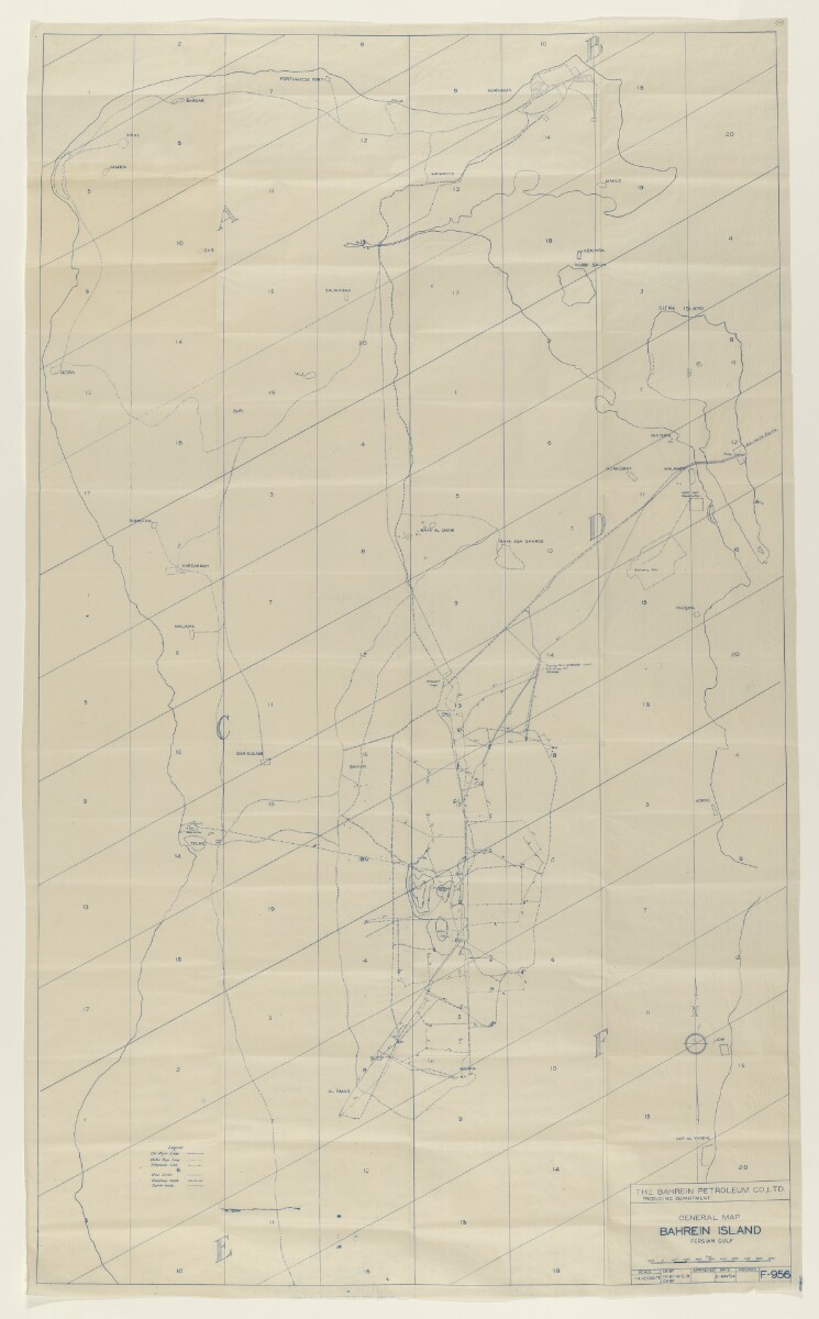
'GENERAL MAP. BAHREIN ISLAND. PERSIAN GULF' [361r] (1/2)
The record is made up of 1 map. It was created in 21 May 1934. It was written in English. The original is part of the British Library: India Office The department of the British Government to which the Government of India reported between 1858 and 1947. The successor to the Court of Directors. Records and Private Papers Documents collected in a private capacity. .
About this item
- Content
Blueprint sketch map produced by the Producing Department of the Bahrain Petroleum Company Limited (BAPCO).
Shows names of settlements, and location of oil pipelines, water pipelines, telephone lines, gas lines, company roads, and 'native' roads, indicated in a key in the lower left portion of the map.
- Extent and format
- 1 map
- Area map covers
- Map loading...
- Scale
- Scale approximately 1:24,000
- Scale designator
- Horizontal
- Orientation
- North
- Degree coordinates
- Top-left: 26° 15' 10" N, 50° 26' 22.58" E
Top-right: 26° 15' 10" N, 50° 38' 44.16" E
Bottom-left: 25° 55' 24.48" N, 50° 26' 22.58" E
Bottom-right: 25° 55' 24.48" N, 50° 38' 44.16" E - Physical characteristics
Materials: blueprint on paper.
Dimensions: 1270 x 820mm, on sheet 1400 x 860mm.
- Written in
- English in Latin script View the complete information for this record
Use and share this item
- Share this item
'GENERAL MAP. BAHREIN ISLAND. PERSIAN GULF' [361r] (1/2), British Library: India Office Records and Private Papers, IOR/L/PS/12/3881, f 361, in Qatar Digital Library <https://www.qdl.qa/archive/81055/vdc_100060843742.0x00007b> [accessed 18 April 2024]
https://www.qdl.qa/en/archive/81055/vdc_100060843742.0x00007b
Copy and paste the code below into your web page where you would like to embed the image.
<meta charset="utf-8"><a href="https://www.qdl.qa/en/archive/81055/vdc_100060843742.0x00007b">'GENERAL MAP. BAHREIN ISLAND. PERSIAN GULF' [‎361r] (1/2)</a> <a href="https://www.qdl.qa/en/archive/81055/vdc_100060843742.0x00007b"> <img src="https://iiif.qdl.qa/iiif/images/81055/vdc_100000000648.0x0001c1/IOR_L_PS_12_3881_0745.jp2/full/!280,240/0/default.jpg" alt="" /> </a>
This record has a IIIF manifest available as follows. If you have a compatible viewer you can drag the icon to load it.https://www.qdl.qa/en/iiif/81055/vdc_100000000648.0x0001c1/manifestOpen in Universal viewerOpen in Mirador viewerMore options for embedding images
Copyright: How to use this content
- Reference
- IOR/L/PS/12/3881, f 361
- Title
- 'GENERAL MAP. BAHREIN ISLAND. PERSIAN GULF'
- Pages
- 361r:361v
- Author
- Bahrain Petroleum Company (BAPCO)
- Usage terms
- The copyright status is unknown. Please contact copyright@bl.uk with any information you have regarding this item.