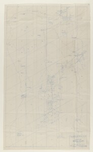
'GENERAL MAP. BAHREIN ISLAND. PERSIAN GULF'
IOR/L/PS/12/3881, f 337
2 items in this record
Search within this record
The record is made up of 1 map. It was created in 10 Jan 1938. It was written in English. The original is part of the British Library: India Office The department of the British Government to which the Government of India reported between 1858 and 1947. The successor to the Court of Directors. Records and Private Papers Documents collected in a private capacity. .
About this record
- Content
Blueprint sketch map dated 21 May 1934, and revised 10 January 1938, produced by the Producing Department of the Bahrain Petroleum Company Limited (BAPCO).
Shows names of settlements, and location of oil pipelines, water pipelines, telephone lines, gas lines, company roads, 'native' roads, and power lines, indicated in a key in the lower left portion of the map.
Also shows BAPCO installations, and locations of wells.
Revisions listed, 1936-38.
- Extent and format
- 1 map
- Area map covers
- Map loading...
- Scale
- Scale approximately 1:24,000
- Scale designator
- Horizontal
- Orientation
- North
- Degree coordinates
- Top-left: 26° 15' 10" N, 50° 26' 22.58" E
Top-right: 26° 15' 10" N, 50° 38' 44.16" E
Bottom-left: 25° 55' 24.48" N, 50° 26' 22.58" E
Bottom-right: 25° 55' 24.48" N, 50° 38' 44.16" E - It is part of
- 767 imagesRef: IOR/L/PS/12/3881
- Physical characteristics
Materials: blueprint on paper.
Dimensions: 1350 x 780mm, on sheet 1410 x 830mm.
- Written in
- English in Latin script
- Type
- Map
Archive information for this record
- Original held at
- British Library: India Office The department of the British Government to which the Government of India reported between 1858 and 1947. The successor to the Court of Directors. Records and Private Papers Documents collected in a private capacity.
- Access conditions
Unrestricted
- Archive reference
- IOR/L/PS/12/3881, f 337
- Former external reference(s)
- F-956
- Date(s)
- 10 Jan 1938 (CE, Gregorian)
Access & Reference
History of this record
Use and share this record
- Share this record
- Cite this record in your research
'GENERAL MAP. BAHREIN ISLAND. PERSIAN GULF', British Library: India Office Records and Private Papers, IOR/L/PS/12/3881, f 337, in Qatar Digital Library <https://www.qdl.qa/archive/81055/vdc_100060862767.0x000007> [accessed 25 April 2024]
- Link to this record
https://www.qdl.qa/en/archive/81055/vdc_100060862767.0x000007
- IIIF details
This record has a IIIF manifest available as follows. If you have a compatible viewer you can drag the icon to load it.https://www.qdl.qa/en/iiif/81055/vdc_100000000648.0x0001c1/manifestOpen in Universal viewerOpen in Mirador viewerMore options for embedding images
Copyright: How to use this content
- Reference
- IOR/L/PS/12/3881, f 337
- Title
- 'GENERAL MAP. BAHREIN ISLAND. PERSIAN GULF'
- Pages
- 337r:337v
- Author
- Bahrain Petroleum Company (BAPCO)
- Usage terms
- The copyright status is unknown. Please contact copyright@bl.uk with any information you have regarding this item.