'Manamah'
IOR/L/PS/12/3782, f 119
2 items in this record
Search within this record
The record is made up of 1 map. It was created in 1934. It was written in English. The original is part of the British Library: India Office The department of the British Government to which the Government of India reported between 1858 and 1947. The successor to the Court of Directors. Records and Private Papers Documents collected in a private capacity. .
About this record
- Content
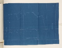
A simple blueprint map of an area of land in Manamah bought by the British Government in 1934. The extent of the land is marked by boundary pillars.
- Extent and format
- 1 map
- It is part of
- 952 imagesRef: IOR/L/PS/12/3782
- Physical characteristics
Materials: printed on drafting cloth
Dimensions: 350mm x 480mm
- Written in
- English in Latin script
- Type
- Map
Archive information for this record
- Original held at
- British Library: India Office The department of the British Government to which the Government of India reported between 1858 and 1947. The successor to the Court of Directors. Records and Private Papers Documents collected in a private capacity.
- Access conditions
Unrestricted
- Archive reference
- IOR/L/PS/12/3782, f 119
- Date(s)
- 1934 (CE, Gregorian)
Access & Reference
History of this record
Use and share this record
- Share this record
- Cite this record in your research
'Manamah', British Library: India Office Records and Private Papers, IOR/L/PS/12/3782, f 119, in Qatar Digital Library <https://www.qdl.qa/archive/81055/vdc_100070042754.0x000003> [accessed 18 April 2024]
- Link to this record
https://www.qdl.qa/en/archive/81055/vdc_100070042754.0x000003
- IIIF details
This record has a IIIF manifest available as follows. If you have a compatible viewer you can drag the icon to load it.https://www.qdl.qa/en/iiif/81055/vdc_100000000648.0x00015d/manifestOpen in Universal viewerOpen in Mirador viewerMore options for embedding images
Copyright: How to use this content
- Reference
- IOR/L/PS/12/3782, f 119
- Title
- 'Manamah'
- Pages
- 119r:119v
- Author
- East India Company, the Board of Control, the India Office, or other British Government Department
- Usage terms
- Open Government Licence