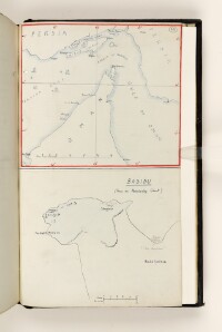
'BASIDU (From an Admiralty Chart)'
IOR/L/PS/10/1094, f 622 2
2 items in this record
Search within this record
The record is made up of 1 map. It was created in 1926?. It was written in English. The original is part of the British Library: India Office The department of the British Government to which the Government of India reported between 1858 and 1947. The successor to the Court of Directors. Records and Private Papers Documents collected in a private capacity. .
About this record
- Content
Sketch map of Basidu, based on an Admiralty chart. The map provides some indication of settlements and vegetation.
- Extent and format
- 1 map
- Scale
- Scale approximately 1:24,369
- Scale designator
- Horizontal
- It is part of
- 1306 imagesRef: IOR/L/PS/10/1094
- Physical characteristics
Materials: Manuscript; black ink, pencil and coloured crayon on paper.
Dimensions: 159 x 181mm, on sheet 201 x 333mm.
- Written in
- English in Latin script
- Type
- Map
Archive information for this record
- Original held at
- British Library: India Office The department of the British Government to which the Government of India reported between 1858 and 1947. The successor to the Court of Directors. Records and Private Papers Documents collected in a private capacity.
- Access conditions
Unrestricted
- Archive reference
- IOR/L/PS/10/1094, f 622 2
- Date(s)
- 1926? (CE, Gregorian)
Access & Reference
History of this record
Use and share this record
- Share this record
- Cite this record in your research
'BASIDU (From an Admiralty Chart)', British Library: India Office Records and Private Papers, IOR/L/PS/10/1094, f 622 2, in Qatar Digital Library <https://www.qdl.qa/archive/81055/vdc_100077110477.0x000001> [accessed 23 April 2024]
- Link to this record
https://www.qdl.qa/en/archive/81055/vdc_100077110477.0x000001
- IIIF details
This record has a IIIF manifest available as follows. If you have a compatible viewer you can drag the icon to load it.https://www.qdl.qa/en/iiif/81055/vdc_100000000419.0x0003de/manifestOpen in Universal viewerOpen in Mirador viewerMore options for embedding images