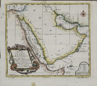
A Chart of the Coast of Arabia, the Red Sea and Persian Gulf, Drawn from the Chart of the Eastern Ocean
2917
1 items in this record
The record is made up of 1 items. It was created in 1740. It was written in English. The original is part of the Qatar National Library.
About this record
- Content
This English map is a reprinting, with slight changes, of an earlier French map published in 1740 by order of Jean-Frédéric Phélypeaux, Count de Maurepas (1701-81), secretary of state under King Louis XV. The map was drawn from an earlier chart of the Eastern Ocean, “improv’d from particular surveys and regulated by astronomical observations.” This English edition of the de Maurepas map has a different title cartouche. The “Remarks” section at the lower right gives abbreviations for physical features on the map, and notes: “ A Stroke under ye Name of a Place denotes ye Latitude having been Observed by Astronomers, and a Prict [sic] Line by skilful Navigators.” Longitude is measured in degrees east of the “Isle de Fer” (Ferro, in the Canary Islands). Town names are as they appeared on the earlier French map. The Red Sea is listed as the “Red Sea or Arabic Gulf.”
- Extent and format
- 1 items
- Physical characteristics
1 map; color; 22 x 24 centimeters
- Written in
- English in Latin script
- Type
- Map
Archive information for this record
- Original held at
- Qatar National Library
- Access conditions
Unrestricted
- Archive reference
- 2917
- Date(s)
- 1740 (CE, Gregorian)
Access & Reference
History of this record
Related search terms
- Subjects
- Persian GulfArabian GulfArabian Peninsula
- Places
- IraqYemenSaudi ArabiaQatarKuwaitOmanUnited Arab Emirates
- People & organisations
- G. Child
Use and share this record
- Share this record
- Cite this record in your research
A Chart of the Coast of Arabia, the Red Sea and Persian Gulf, Drawn from the Chart of the Eastern Ocean, Qatar National Library, 2917, in Qatar Digital Library <https://www.qdl.qa/archive/qnlhc/2917> [accessed 25 April 2024]
- Link to this record
https://www.qdl.qa/en/archive/qnlhc/2917
- IIIF details
This record has a IIIF manifest available as follows. If you have a compatible viewer you can drag the icon to load it.https://www.qdl.qa/en/iiif/qnlhc/2917/manifestOpen in Universal viewerOpen in Mirador viewerMore options for embedding images
Copyright: How to use this content
- Reference
- 2917
- Title
- A Chart of the Coast of Arabia, the Red Sea and Persian Gulf, Drawn from the Chart of the Eastern Ocean
- Pages
- F-1-1 - F-1-1
- Author
- Qatar National Library
- Usage terms
- Public Domain