Arabia
2919
1 items in this record
The record is made up of 1 items. It was created in 1622/1680. It was written in Latin. The original is part of the Qatar National Library.
About this record
- Content
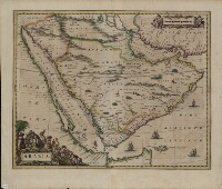
This 1662 Latin map of Arabia is a copy of an earlier map by Willem Janszoon Blaeu (1571-1638), the founder of the Blaeu cartographic firm. It is one of the first maps to show internal features of the Arabian Peninsula. Mountains are depicted, oases denoted by trees, and points used to indicate pearl deposits in the Arabian Gulf. The map uses dotted lines to show international borders. The Red Sea is denoted by three Latin names: Mare Rubrum (Red Sea), Mare Mecca (Sea of Mecca), and Sinus Arabicus (Gulf of Arabia). The Blaeu firm published the first edition of the Atlas Novus (New atlas) in 1635. Sons Joan (1596-1673) and Cornelis (died 1648) took over the firm after their father’s death and continued to produce expanded and improved editions of the atlas.
- Extent and format
- 1 items
- Physical characteristics
1 map; color; 40 x 51 centimeters
- Written in
- Latin in Latin script
- Type
- Map
Archive information for this record
- Original held at
- Qatar National Library
- Access conditions
Unrestricted
- Archive reference
- 2919
- Date(s)
- 1622/1680 (CE, Gregorian)
Access & Reference
History of this record
Related search terms
- Subjects
- Persian GulfArabian GulfArabian Peninsula
- Places
- IraqYemenSaudi ArabiaQatarKuwaitOmanUnited Arab Emirates
- People & organisations
- Willem Janszoon Blaeu
Use and share this record
- Share this record
- Cite this record in your research
Arabia, Qatar National Library, 2919, in Qatar Digital Library <https://www.qdl.qa/archive/qnlhc/2919> [accessed 24 April 2024]
- Link to this record
https://www.qdl.qa/en/archive/qnlhc/2919
- IIIF details
This record has a IIIF manifest available as follows. If you have a compatible viewer you can drag the icon to load it.https://www.qdl.qa/en/iiif/qnlhc/2919/manifestOpen in Universal viewerOpen in Mirador viewerMore options for embedding images
Copyright: How to use this content
- Reference
- 2919
- Title
- Arabia
- Pages
- F-1-1 - F-1-1
- Author
- Qatar National Library
- Usage terms
- Public Domain