Explore Qatar Digital Library
- Items in the archive (2,456,573)
- Articles from our experts (239)
- Search tips Tips and syntax for searching
Showing records 16,041 to 16,050
-

File [10/12] Tribal and desert information: Ikhwan raids on Kuwait and defensive measures
This file contains correspondence related to the British Government's relationship with Ibn Sa'ud [‘Abd al-‘Azīz bin ‘Abd al-Raḥmān bin Fayṣal ...
576 images in record Ref: IOR/R/15/5/39 Date(s): 1 Jan 1928-31 Mar 1928
![]()
![]()
![]()
![]()
![]()
![]()
![]()
![]()
![]()
![]()
![]()
![]()
![]()
![]()
![]()
![]()
![]()
![]()
![]()
![]()
![]()
![]()
![]()
![]()
![]()
![]()
![]()
![]()
![]()
![]()
-

File 10/12 Tribal and desert information: Ikhwan raids; Motor Transport Concession, Kuwait/Basra; Ikhwan rebellion, 1927
This file contains correspondence related to the British Government's relationship with Ibn Sa'ud [‘Abd al-‘Azīz bin ‘Abd al-Raḥmān bin Fayṣal ...
646 images in record Ref: IOR/R/15/5/38 Date(s): 7 Jan 1925-31 Dec 1927
![]()
![]()
![]()
![]()
![]()
![]()
![]()
![]()
![]()
![]()
![]()
![]()
![]()
![]()
![]()
![]()
![]()
![]()
![]()
![]()
![]()
![]()
![]()
![]()
![]()
![]()
![]()
![]()
![]()
![]()
-

File 37/1905 Pt 2 'Aden Frontier Delimitation'
This file contains correspondence and reports related to the work of the Aden Boundary Commission, the British Government body tasked with the delineation ...
796 images in record Ref: IOR/L/PS/10/64 Date(s): 1902
![]()
![]()
![]()
![]()
![]()
![]()
![]()
![]()
![]()
![]()
![]()
![]()
![]()
![]()
![]()
![]()
![]()
![]()
![]()
![]()
![]()
![]()
![]()
![]()
![]()
![]()
![]()
![]()
![]()
![]()
-
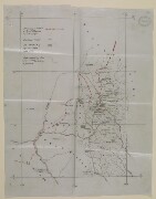
Sketch Map of Aden Protectorate Border Region
A hand-drawn map of the border region of the British Protectorate of Aden. Dimensions: 390mm x 490mm Materials: 1 paper folio English Latin East India ...
2 images in record Ref: IOR/L/PS/10/64, f 348 Date(s): 1902
![]()
![]()
-

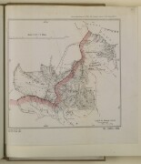
Printed Map of Aden Protectorate Border Region
A printed map of the border region of the British protectorate of Aden that shows the area surveyed by the British in 1902. Dimensions: 390mm x 295mm Materials: ...
2 images in record Ref: IOR/L/PS/10/64, f 349 Date(s): 1902
![]()
![]()
-

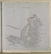
Printed Map of Aden Protectorate Border Region
A printed map of the border region of the British protectorate of Aden that shows the area surveyed by the British in 1902. Dimensions: 340mm x 245mm Materials: ...
2 images in record Ref: IOR/L/PS/10/64, f 350 Date(s): 1902
![]()
![]()
-
Printed Map of Aden Protectorate Border Region
A printed map of the border area of the British Protectorate of Aden. The map is signed by Colonel R A Wahab, Commissioner of the Aden Boundary Commission ...
2 images in record Ref: IOR/L/PS/10/64, f 377 Date(s): 1902
![]()
![]()
-

File 37/1905 Pt 1 'Aden Frontier Delimitation'
This file contains correspondence and reports related to the work of the Aden Boundary Commission, the British Government body tasked with the delineation ...
1,104 images in record Ref: IOR/L/PS/10/63 Date(s): 1901-1902
![]()
![]()
![]()
![]()
![]()
![]()
![]()
![]()
![]()
![]()
![]()
![]()
![]()
![]()
![]()
![]()
![]()
![]()
![]()
![]()
![]()
![]()
![]()
![]()
![]()
![]()
![]()
![]()
![]()
![]()
-

Printed Map of Aden Protectorate Border Region
A map of the border region of the British Protectorate of Aden signed by Colonel R A Wahab, the Commissioner of the Aden Boundary Commission. The map accompanies ...
2 images in record Ref: IOR/L/PS/10/63, f 67 Date(s): 1902
![]()
![]()
-
Sketch Map of Aden Protectorate Border Region
A map of the border region of the British Protectorate of Aden with the limit of the Aden Boundary Commission's survey marked clearly in red. Dimensions: ...
2 images in record Ref: IOR/L/PS/10/63, f 77 Date(s): 1902
![]()
![]()


