!["تقرير عسكري عن جنوب غرب بلاد فارس، يتضمن أقاليم خوزستان (عربستان)، لورستان، وجزءًا من فارس" [<span dir="ltr">١٩٠</span>] (٤٦٦/١٩١)](https://iiif.qdl.qa/iiif/images/81055/vdc_100023517327.0x000001/V 8685_0199.jp2/full/!1200,1200/0/default.jpg "\"تقرير عسكري عن جنوب غرب بلاد فارس، يتضمن أقاليم خوزستان (عربستان)، لورستان، وجزءًا من فارس\" [<span dir=\"ltr\">١٩٠</span>] (٤٦٦/١٩١)")
"تقرير عسكري عن جنوب غرب بلاد فارس، يتضمن أقاليم خوزستان (عربستان)، لورستان، وجزءًا من فارس" [١٩٠] (٤٦٦/١٩١)
محتويات السجل: مجلد واحد (٣٩٠ صفحة). يعود تاريخه إلى ١٨٨٥. اللغة أو اللغات المستخدمة: الإنجليزية. النسخة الأصلية محفوظة في المكتبة البريطانية: مجموعات مطبوعة.
نسخ
النسخ مستحدث آليًا ومن المرجّح أن يحتوي على أخطاء.
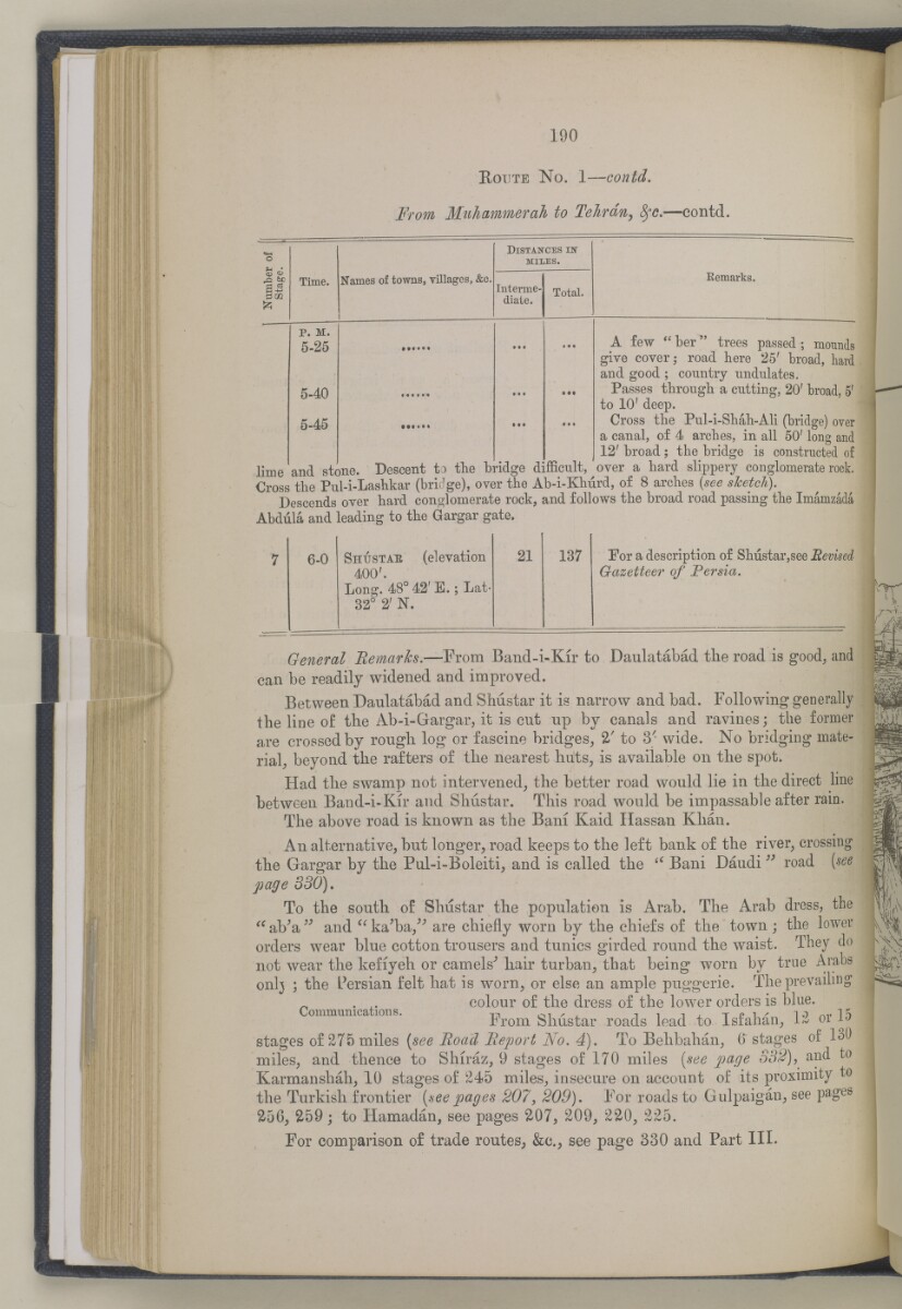
190
R oute N o. 1 — contd.
From Mtihammerah to Tehran, tyc. —contd.
,£2 6C
0 02
^5
Time.
Names of towns, villages, &c,
Distances iif
MILES.
Interme
diate.
P. M.
5-25
5-40
5-45
Total.
Eemarks.
lime and stone.
A few <£ ber" trees passed ; mounds
give cover; road here 25' broad, hard
and good ; conntry undulates.
Passes throngli a cutting, 20' broad, 5 r
to 10' deep.
Cross the Pul-i-Sbab-Ali (bridge) over
a canal, of 4 arches, in all 50' long and
12' broad ; the bridge is constructed of
over a hard slippery conglomerate rock.
Descent to the bridge difficult.
Cross The Pul-i-Lashkar (bridge), over the Ab-i-KMrd, of 8 arches [see sJcetch).
Descends over hard conglomerate rock, and follows the broad road passing the Imamzada
Abdiila and leading to the Gargar gate.
7
6-0
S hustae (elevation
21
137
For a description of Shustar,see Revised
400'.
Gazetteer of Persia.
Long. 48° 42' E.; Lat-
32° 2' N.
General Bemarks. —From Band-i-Kir to Daulatabad the road is good ; and
can be readily widened and improved.
Between Daulatabad and SMstar it is narrow and bad. Following generally
the line of the Ab-i-Gargar, it is cut up by canals and ravines; the former
are crossed by rough log or fascine bridges^ 2/ to 3'- wide. No bridging mate
rial, beyond the rafters of the nearest hiits, is available on the spot.
Had the swamp not intervened, the better road would lie in the direct line
between Band-i-Kir and Shustar. This road would be impassable after rain.
The above road is known as the Bam Kaid Hassan Khan.
An alternative, but longer, road keeps to the left bank of the river, crossing
the Gargar by the Pul-i-Boleiti, and is called the <c Bani Daudi " road [see
page 330),
To the south of Shustar the population is Arab. The Arab dress, the
" aVa " and " ka^ba/"' are chiefly worn by the chiefs of the town ; the lower
orders wear blue cotton trousers and tunics girded round the waist. They do
not wear the kefiyeh or camels^ hair turban, that being worn by true Arabs
onlj ; the Persian felt hat is worn, or else an ample puggerie. The prevailing
. ,. colour of the dress of the lower orders is blue,
ommumca ions. From Shustar roads lead to Isfahan, 1% or 15
stages of 275 miles {see Road Report No. 4). To Behbahan, 6" stages of 130
miles, and thence to Shiraz, 9 stages of 170 miles [see page 332), and to
Karmanshah, 10 stages of 245 miles, insecure on account of its proximity to
the Turkish frontier [see pages 207, 209). For roads to Gulpaigan, see pages
256, 259; to Hamadan, see pages 207, 209, 220, 225.
For comparison of trade routes^ &c., see page 330 and Part III.
حول هذه المادة
- المحتوى
قرير عسكري عن جنوب غرب بلاد فارس، يتضمن أقاليم خوزستان (عربستان)، لورستان، وجزءًا من فارس بقلم الرائد والبارونيت. المقدم مارك س. بيل، وسام صليب فيكتوريا، فيلق المهندسين الملكي.
بيانات النشر: شيملا: مطبعة الفرع المركزي للحكومة، ١٨٨٥. أُعد في فرع الاستخبارات لإدارة قائد الإمداد والتموين في الهند.
الوصف المادي: ٣ خرائط في جيوب في النهاية. ٤١ لوحة.
- الشكل والحيّز
- مجلد واحد (٣٩٠ صفحة)
- الترتيب
يحتوي هذا المجلد على فهرس محتويات يشمل عناوين الفصول ومراجع الصفحات.
- الخصائص المادية
الأبعاد: ٢٤٥ مم × ١٥٠ مم
- لغة الكتابة
- الإنجليزية بالأحرف اللاتينية للاطّلاع على المعلومات الكاملة لهذا السجل
استخدام وإعادة نشر هذه المادة
- إعادة نشر هذه المادة
"تقرير عسكري عن جنوب غرب بلاد فارس، يتضمن أقاليم خوزستان (عربستان)، لورستان، وجزءًا من فارس" [١٩٠] (٤٦٦/١٩١)و المكتبة البريطانية: مجموعات مطبوعةو V 8685و مكتبة قطر الرقمية <https://www.qdl.qa/archive/81055/vdc_100023694939.0x0000c0> [تم الوصول إليها في ١٩ April ٢٠٢٤]
https://www.qdl.qa/العربية/archive/81055/vdc_100023694939.0x0000c0
يمكنك نسخ ولصق الفقرة التالية لتضمين الصورة في صفحة الويب الخاصة بك.
<meta charset="utf-8"><a href="https://www.qdl.qa/العربية/archive/81055/vdc_100023694939.0x0000c0">"تقرير عسكري عن جنوب غرب بلاد فارس، يتضمن أقاليم خوزستان (عربستان)، لورستان، وجزءًا من فارس" [<span dir="ltr">١٩٠</span>] (٤٦٦/١٩١)</a> <a href="https://www.qdl.qa/العربية/archive/81055/vdc_100023694939.0x0000c0"> <img src="https://iiif.qdl.qa/iiif/images/81055/vdc_100023517327.0x000001/V 8685_0199.jp2/full/!280,240/0/default.jpg" alt="" /> </a>
هذا التسجيل IIIF له ملف ظاهر متوفر كما يلي. إذا كان لديك عارض متوافق للصور يمكنك سحب الأيقونة لتحميله.https://www.qdl.qa/العربية/iiif/81055/vdc_100023517327.0x000001/manifestافتح في المتصفح العامافتح في عارض IIIF ميرادورطرق إضافية لاستخدام صور الأرشيف الرقمي
حقوق النسخ والتأليف: كيفية استخدام هذا المحتوى
- رقم الاستدعاء
- V 8685
- العنوان
- "تقرير عسكري عن جنوب غرب بلاد فارس، يتضمن أقاليم خوزستان (عربستان)، لورستان، وجزءًا من فارس"
- الصفحات
- داخلي-خلفي ،٢:١ ،ظ-iv:و-iii ،١٠:١ ،٣٩٠:٣٦٧ ،ن٣٦٦:أ٣٦٦ ،٣٦٦:٣٣٥ ،ب٣٣٤:أ٣٣٤ ،٣٣٤:٢٧٣ ،د٢٧٢:أ٢٧٢ ،٢٧٢:٢٧١ ،ب٢٧٠:أ٢٧٠ ،٢٧٠:٢٦٥ ،ب٢٦٤:أ٢٦٤ ،٢٦٤:٢٥٥ ،ب٢٥٤:أ٢٥٤ ،٢٥٤:٢٥٣ ،ب٢٥٢:أ٢٥٢ ،٢٥٢:٢٤٩ ،ب٢٤٨:أ٢٤٨ ،٢٤٨:٢٤٧ ،ب٢٤٦:أ٢٤٦ ،٢٤٦:٢٤٥ ،د٢٤٤:أ٢٤٤ ،٢٤٤:٢٤١ ،ب٢٤٠:أ٢٤٠ ،٢٤٠:٢٣٧ ،ب٢٣٦:أ٢٣٦ ،٢٣٦:٢٣١ ،ب٢٣٠:أ٢٣٠ ،٢٣٠:٢١٣ ،ب٢١٢:أ٢١٢ ،٢١٢:٢١١ ،ب٢١٠:أ٢١٠ ،٢١٠:٢٠٩ ،د٢٠٨:أ٢٠٨ ،٢٠٨:٢٠٥ ،ب٢٠٤:أ٢٠٤ ،٢٠٤:١٩٣ ،ب١٩٢:أ١٩٢ ،١٩٢:١٩١ ،د١٩٠:أ١٩٠ ،١٩٠:١٨٥ ،ب١٨٤:أ١٨٤ ،١٨٤:١٧٩ ،ب١٧٨:أ١٧٨ ،١٧٨:١٧٧ ،ب١٧٦:أ١٧٦ ،١٧٦:١٦٧ ،ب١١٦:أ١١٦ ،١١٦:١١٣ ،ب١١٢:أ١١٢ ،١١٢:١٠٩ ،ب١٠٨:أ١٠٨ ،١٠٨:٩٩ ،ب٩٨:أ٩٨ ،٩٨:٩٧ ،ب٩٦:أ٩٦ ،٩٦:٦٥ ،ب٦٤:أ٦٤ ،٦٤:٦١ ،ب٦٠:أ٦٠ ،٦٠:٥٥ ،ب٥٤:أ٥٤ ،٥٤:٤١ ،ب٤٠:أ٤٠ ،٤٠:٥ ،ب٤:أ٤ ،٤:٣ ،ب٢:أ٢ ،٢:١ ،٨:١ ،ظ-ii:و-i ،٤:١ ،داخلي-أمامي ،ذيل ،رأس ،حافة ،صلب ،خلفي ،أمامي
- المؤلف
- Bell, Mark Sever
- شروط الاستخدام
- نطاق عام