!["تقرير عسكري عن جنوب غرب بلاد فارس، يتضمن أقاليم خوزستان (عربستان)، لورستان، وجزءًا من فارس" [<span dir="ltr">٢٢٣</span>] (٤٦٦/٢٤٢)](https://iiif.qdl.qa/iiif/images/81055/vdc_100023517327.0x000001/V 8685_0262.jp2/full/!1200,1200/0/default.jpg "\"تقرير عسكري عن جنوب غرب بلاد فارس، يتضمن أقاليم خوزستان (عربستان)، لورستان، وجزءًا من فارس\" [<span dir=\"ltr\">٢٢٣</span>] (٤٦٦/٢٤٢)")
"تقرير عسكري عن جنوب غرب بلاد فارس، يتضمن أقاليم خوزستان (عربستان)، لورستان، وجزءًا من فارس" [٢٢٣] (٤٦٦/٢٤٢)
محتويات السجل: مجلد واحد (٣٩٠ صفحة). يعود تاريخه إلى ١٨٨٥. اللغة أو اللغات المستخدمة: الإنجليزية. النسخة الأصلية محفوظة في المكتبة البريطانية: مجموعات مطبوعة.
نسخ
النسخ مستحدث آليًا ومن المرجّح أن يحتوي على أخطاء.
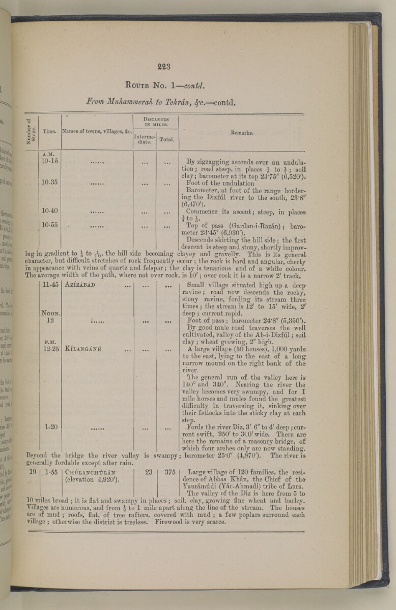
223
Route No. 1— contd.
From Muhammerah to Tehran, fyc, —contd.
I-
Time.
Names of towns, villages, &c
Distances
in" miles.
Interme
diate.
Total.
Eemarks.
a.m.
10-15
10-35
10-40
10-55
Top of pass (Gardan-i-Kazan)
meter 28-45' / (6,930').
Descends skirting the hill side ; the first
descent is steep and stony, shortly improv
ing in gradient to | to y 1 ^, the hill side becoming clayey and gravelly. This is its general
character, hut difficulty stretches of rock frequently occur ; the rock is hard and angular, cherty
in appearance with veins of quartz and felspar ; the clay is tenacious and of a white colour.
The average width of the path, where not over rock, is 10'; over rock it is a narrow 2' track.
By zigzagging ascends over an undula
tion ; road steep, in places -J- to ; soil
clay; barometer at its top 23"75 // (6,520%
Foot of the undulation
Barometer, at foot of the range border
ing the Dizful river to the south, 23 , 8 /r
(6,470').
Commence its ascent; steep, in places
baro-
11-45
N oon.
12
p.m.
12-25
1-20
A zizab I d
KlLANGriNE
Beyond the bridge the river valley is swampy
generally fordable except after rain.
Small village situated high up a deep
ravine,- road now descends the rocky,
stony ravine, fording its stream three
times; the stream is 12' to 15' wide, 2 r
deep; current rapid.
Foot of pass ; barometer 24*8'' (5,350')..
By good mule road traverses the well
cultivated, valley of the Ab-i-Dizful; soil
clay ; wheat growing, 2" high.
A large village (50 houses), 1,000 yards
to the east, lying to the east of a long:
narrow mound on the right bank of the
river.
The general run of the valley here is
140° and 340°. Nearing the river the
valley becomes very swampy, and for 1
mile horses and mules found the greatest
difficulty in traversing it, sinking over
their fetlocks into the sticky clay at each
step.
Fords the river Diz, 3' 6" to 4' deep ; cur
rent swift, 250' to 3C0' wide. There are
here the remains of a masonry bridge, of
which four arches only are now standing,
barometer 25"0 / ' (4,870'). The river is
]9
1-55
CHULANCHULiN
(elevation 4,920').
23
375
Large village of 120 families, the resi
dence of Abbas Khan, the Chief of the
Yauramudi (Yar-Ahmadi) tribe of Lurs.
The valley of the Diz is here from 5 to
10 miles broad ; it is flat and swampy in places ; soil, clay, growing fine wheat and barley.
Villages are numerous, and from J to 1 mile apart along the line of the stream. The houses
are of mud ; roofs, flat, of tree rafters, covered with mud ; a few poplars surround each
village ; otherwise the district is treeless. Firewood is very scarce.
حول هذه المادة
- المحتوى
قرير عسكري عن جنوب غرب بلاد فارس، يتضمن أقاليم خوزستان (عربستان)، لورستان، وجزءًا من فارس بقلم الرائد والبارونيت. المقدم مارك س. بيل، وسام صليب فيكتوريا، فيلق المهندسين الملكي.
بيانات النشر: شيملا: مطبعة الفرع المركزي للحكومة، ١٨٨٥. أُعد في فرع الاستخبارات لإدارة قائد الإمداد والتموين في الهند.
الوصف المادي: ٣ خرائط في جيوب في النهاية. ٤١ لوحة.
- الشكل والحيّز
- مجلد واحد (٣٩٠ صفحة)
- الترتيب
يحتوي هذا المجلد على فهرس محتويات يشمل عناوين الفصول ومراجع الصفحات.
- الخصائص المادية
الأبعاد: ٢٤٥ مم × ١٥٠ مم
- لغة الكتابة
- الإنجليزية بالأحرف اللاتينية للاطّلاع على المعلومات الكاملة لهذا السجل
استخدام وإعادة نشر هذه المادة
- إعادة نشر هذه المادة
"تقرير عسكري عن جنوب غرب بلاد فارس، يتضمن أقاليم خوزستان (عربستان)، لورستان، وجزءًا من فارس" [٢٢٣] (٤٦٦/٢٤٢)و المكتبة البريطانية: مجموعات مطبوعةو V 8685و مكتبة قطر الرقمية <https://www.qdl.qa/archive/81055/vdc_100023694940.0x000029> [تم الوصول إليها في ١٨ April ٢٠٢٤]
https://www.qdl.qa/العربية/archive/81055/vdc_100023694940.0x000029
يمكنك نسخ ولصق الفقرة التالية لتضمين الصورة في صفحة الويب الخاصة بك.
<meta charset="utf-8"><a href="https://www.qdl.qa/العربية/archive/81055/vdc_100023694940.0x000029">"تقرير عسكري عن جنوب غرب بلاد فارس، يتضمن أقاليم خوزستان (عربستان)، لورستان، وجزءًا من فارس" [<span dir="ltr">٢٢٣</span>] (٤٦٦/٢٤٢)</a> <a href="https://www.qdl.qa/العربية/archive/81055/vdc_100023694940.0x000029"> <img src="https://iiif.qdl.qa/iiif/images/81055/vdc_100023517327.0x000001/V 8685_0262.jp2/full/!280,240/0/default.jpg" alt="" /> </a>
هذا التسجيل IIIF له ملف ظاهر متوفر كما يلي. إذا كان لديك عارض متوافق للصور يمكنك سحب الأيقونة لتحميله.https://www.qdl.qa/العربية/iiif/81055/vdc_100023517327.0x000001/manifestافتح في المتصفح العامافتح في عارض IIIF ميرادورطرق إضافية لاستخدام صور الأرشيف الرقمي
حقوق النسخ والتأليف: كيفية استخدام هذا المحتوى
- رقم الاستدعاء
- V 8685
- العنوان
- "تقرير عسكري عن جنوب غرب بلاد فارس، يتضمن أقاليم خوزستان (عربستان)، لورستان، وجزءًا من فارس"
- الصفحات
- داخلي-خلفي ،٢:١ ،ظ-iv:و-iii ،١٠:١ ،٣٩٠:٣٦٧ ،ن٣٦٦:أ٣٦٦ ،٣٦٦:٣٣٥ ،ب٣٣٤:أ٣٣٤ ،٣٣٤:٢٧٣ ،د٢٧٢:أ٢٧٢ ،٢٧٢:٢٧١ ،ب٢٧٠:أ٢٧٠ ،٢٧٠:٢٦٥ ،ب٢٦٤:أ٢٦٤ ،٢٦٤:٢٥٥ ،ب٢٥٤:أ٢٥٤ ،٢٥٤:٢٥٣ ،ب٢٥٢:أ٢٥٢ ،٢٥٢:٢٤٩ ،ب٢٤٨:أ٢٤٨ ،٢٤٨:٢٤٧ ،ب٢٤٦:أ٢٤٦ ،٢٤٦:٢٤٥ ،د٢٤٤:أ٢٤٤ ،٢٤٤:٢٤١ ،ب٢٤٠:أ٢٤٠ ،٢٤٠:٢٣٧ ،ب٢٣٦:أ٢٣٦ ،٢٣٦:٢٣١ ،ب٢٣٠:أ٢٣٠ ،٢٣٠:٢١٣ ،ب٢١٢:أ٢١٢ ،٢١٢:٢١١ ،ب٢١٠:أ٢١٠ ،٢١٠:٢٠٩ ،د٢٠٨:أ٢٠٨ ،٢٠٨:٢٠٥ ،ب٢٠٤:أ٢٠٤ ،٢٠٤:١٩٣ ،ب١٩٢:أ١٩٢ ،١٩٢:١٩١ ،د١٩٠:أ١٩٠ ،١٩٠:١٨٥ ،ب١٨٤:أ١٨٤ ،١٨٤:١٧٩ ،ب١٧٨:أ١٧٨ ،١٧٨:١٧٧ ،ب١٧٦:أ١٧٦ ،١٧٦:١٦٧ ،ب١١٦:أ١١٦ ،١١٦:١١٣ ،ب١١٢:أ١١٢ ،١١٢:١٠٩ ،ب١٠٨:أ١٠٨ ،١٠٨:٩٩ ،ب٩٨:أ٩٨ ،٩٨:٩٧ ،ب٩٦:أ٩٦ ،٩٦:٦٥ ،ب٦٤:أ٦٤ ،٦٤:٦١ ،ب٦٠:أ٦٠ ،٦٠:٥٥ ،ب٥٤:أ٥٤ ،٥٤:٤١ ،ب٤٠:أ٤٠ ،٤٠:٥ ،ب٤:أ٤ ،٤:٣ ،ب٢:أ٢ ،٢:١ ،٨:١ ،ظ-ii:و-i ،٤:١ ،داخلي-أمامي ،ذيل ،رأس ،حافة ،صلب ،خلفي ،أمامي
- المؤلف
- Bell, Mark Sever
- شروط الاستخدام
- نطاق عام