!["تقرير عسكري عن جنوب غرب بلاد فارس، يتضمن أقاليم خوزستان (عربستان)، لورستان، وجزءًا من فارس" [<span dir="ltr">٢٣٢</span>] (٤٦٦/٢٥٣)](https://iiif.qdl.qa/iiif/images/81055/vdc_100023517327.0x000001/V 8685_0273.jp2/full/!1200,1200/0/default.jpg "\"تقرير عسكري عن جنوب غرب بلاد فارس، يتضمن أقاليم خوزستان (عربستان)، لورستان، وجزءًا من فارس\" [<span dir=\"ltr\">٢٣٢</span>] (٤٦٦/٢٥٣)")
"تقرير عسكري عن جنوب غرب بلاد فارس، يتضمن أقاليم خوزستان (عربستان)، لورستان، وجزءًا من فارس" [٢٣٢] (٤٦٦/٢٥٣)
محتويات السجل: مجلد واحد (٣٩٠ صفحة). يعود تاريخه إلى ١٨٨٥. اللغة أو اللغات المستخدمة: الإنجليزية. النسخة الأصلية محفوظة في المكتبة البريطانية: مجموعات مطبوعة.
نسخ
النسخ مستحدث آليًا ومن المرجّح أن يحتوي على أخطاء.
m
U otjt E No. 1— contd.
Vrom Muhammeralt to Tehran, -contd,
"o
Distances in
miles.
« tr
E
&
Time.
Names of towns, villages, &c.
Interme
diate.
Total.
Remarks.
wide, generally easy ; gradient ^ to T V ; a stream courses down it. Bed of the gorge stony; it
leads to the picturesque and fertile valley or the Ab-i-Kallaru, ig to J miles broad, crowded
with large villages, of which the chief are Silayjo and Kallaru.
Skirts the left side of the valley.
noon.
12
p.m.
12-45
Rounds the shaly hill side worn into
numerous mule tracks by traffic, and de
scends gently to the plateau in which
stands Sultanabad.
j^Q ^ kf .. ... ... Passes vineyards surrounded by high
mud walls. Crosses the dilapidated
bridge of 4 arches over the Ab-i-Kalla-
m ; bridge 100' long; its arch stones are
of slabs of shale ; it has no parapet wall; falling into ruins, its width is in places 8' ; no
span exceeds 15'; the stream at this season is shallow and runs in a deep bed ; bouldery
bottom.
23
S ult I nabad (eleva
tion 6,110').
Long. 48° 45'E.
Lat. 34° 6' 3G" N.
1-30 S ult I nab I d (eleva- 24 453 The outskirts of the town are in ruins;
barometer 24*1 // .
General remarTcs. —The road, since en-
teriiig the Tang-i-Tura, is in good order,
although unformed, and offers no difficul
ties - its surface is generally stony and hard ; the stretches of clay would become difficult after
rain'and snow. There is no indication of heavy traffic along it except at the one point noted.
Its averao-e width is 20' to 30' ; gradients along it are gentle. The country it traverses is
picturesque; the hills rise to a height of 500' to 600' over the general level, and are barren
and inaccessible ; those to the south of the road only are snow-topped.
Sultanabad, lying in a wide basin of about 20 miles in diameter, is a town of commercial
importance, the centre of a carpet manufacturing district. The country round about is
generally fertile, and produces average crops of cerealsvines flourish. To its north-east,
distant 4 miles, lies a salt lake of a diameter of 4 to 5^ miles.
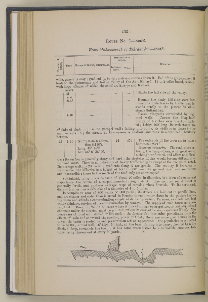
It occupies an area of 800 yards X 800 yards ; its streets are laid out in parallel lines,
and are cleaner and wider than is usual in Persian towns ; water flows in the gutters border
ing them and affords a contamination supply of drinking-water; Persians, as a rule are foul
water drinkers, careless of its contamination by sewage. The supply of such towns as Shus-
tar, Dizfiil, Burujird, &c., in all cases where it flows through open gutters, or partially clewed
channels under the streets, must be polluted, unless its current be very rapid {see Kum). Ine
liouses are of mud with domed or flat roofs ; the former fall into ruins periodically from the
effects of rain and snow and the swelling power of frost; there are some good houses m the
town ; the bazar is roofed in and presented an active appearance ; the population is estimated
to be 4,000 ; a mud wall, 16' high, 5' thick, at the base, falling into decay, fronted by a dry
ditch, 6' deep, surrounds the town ; it has some resemblance to a defensible enceinte, bas
tions being thrown out at every 50 yards.
حول هذه المادة
- المحتوى
قرير عسكري عن جنوب غرب بلاد فارس، يتضمن أقاليم خوزستان (عربستان)، لورستان، وجزءًا من فارس بقلم الرائد والبارونيت. المقدم مارك س. بيل، وسام صليب فيكتوريا، فيلق المهندسين الملكي.
بيانات النشر: شيملا: مطبعة الفرع المركزي للحكومة، ١٨٨٥. أُعد في فرع الاستخبارات لإدارة قائد الإمداد والتموين في الهند.
الوصف المادي: ٣ خرائط في جيوب في النهاية. ٤١ لوحة.
- الشكل والحيّز
- مجلد واحد (٣٩٠ صفحة)
- الترتيب
يحتوي هذا المجلد على فهرس محتويات يشمل عناوين الفصول ومراجع الصفحات.
- الخصائص المادية
الأبعاد: ٢٤٥ مم × ١٥٠ مم
- لغة الكتابة
- الإنجليزية بالأحرف اللاتينية للاطّلاع على المعلومات الكاملة لهذا السجل
استخدام وإعادة نشر هذه المادة
- إعادة نشر هذه المادة
"تقرير عسكري عن جنوب غرب بلاد فارس، يتضمن أقاليم خوزستان (عربستان)، لورستان، وجزءًا من فارس" [٢٣٢] (٤٦٦/٢٥٣)و المكتبة البريطانية: مجموعات مطبوعةو V 8685و مكتبة قطر الرقمية <https://www.qdl.qa/archive/81055/vdc_100023694940.0x000034> [تم الوصول إليها في ١٦ April ٢٠٢٤]
https://www.qdl.qa/العربية/archive/81055/vdc_100023694940.0x000034
يمكنك نسخ ولصق الفقرة التالية لتضمين الصورة في صفحة الويب الخاصة بك.
<meta charset="utf-8"><a href="https://www.qdl.qa/العربية/archive/81055/vdc_100023694940.0x000034">"تقرير عسكري عن جنوب غرب بلاد فارس، يتضمن أقاليم خوزستان (عربستان)، لورستان، وجزءًا من فارس" [<span dir="ltr">٢٣٢</span>] (٤٦٦/٢٥٣)</a> <a href="https://www.qdl.qa/العربية/archive/81055/vdc_100023694940.0x000034"> <img src="https://iiif.qdl.qa/iiif/images/81055/vdc_100023517327.0x000001/V 8685_0273.jp2/full/!280,240/0/default.jpg" alt="" /> </a>
هذا التسجيل IIIF له ملف ظاهر متوفر كما يلي. إذا كان لديك عارض متوافق للصور يمكنك سحب الأيقونة لتحميله.https://www.qdl.qa/العربية/iiif/81055/vdc_100023517327.0x000001/manifestافتح في المتصفح العامافتح في عارض IIIF ميرادورطرق إضافية لاستخدام صور الأرشيف الرقمي
حقوق النسخ والتأليف: كيفية استخدام هذا المحتوى
- رقم الاستدعاء
- V 8685
- العنوان
- "تقرير عسكري عن جنوب غرب بلاد فارس، يتضمن أقاليم خوزستان (عربستان)، لورستان، وجزءًا من فارس"
- الصفحات
- داخلي-خلفي ،٢:١ ،ظ-iv:و-iii ،١٠:١ ،٣٩٠:٣٦٧ ،ن٣٦٦:أ٣٦٦ ،٣٦٦:٣٣٥ ،ب٣٣٤:أ٣٣٤ ،٣٣٤:٢٧٣ ،د٢٧٢:أ٢٧٢ ،٢٧٢:٢٧١ ،ب٢٧٠:أ٢٧٠ ،٢٧٠:٢٦٥ ،ب٢٦٤:أ٢٦٤ ،٢٦٤:٢٥٥ ،ب٢٥٤:أ٢٥٤ ،٢٥٤:٢٥٣ ،ب٢٥٢:أ٢٥٢ ،٢٥٢:٢٤٩ ،ب٢٤٨:أ٢٤٨ ،٢٤٨:٢٤٧ ،ب٢٤٦:أ٢٤٦ ،٢٤٦:٢٤٥ ،د٢٤٤:أ٢٤٤ ،٢٤٤:٢٤١ ،ب٢٤٠:أ٢٤٠ ،٢٤٠:٢٣٧ ،ب٢٣٦:أ٢٣٦ ،٢٣٦:٢٣١ ،ب٢٣٠:أ٢٣٠ ،٢٣٠:٢١٣ ،ب٢١٢:أ٢١٢ ،٢١٢:٢١١ ،ب٢١٠:أ٢١٠ ،٢١٠:٢٠٩ ،د٢٠٨:أ٢٠٨ ،٢٠٨:٢٠٥ ،ب٢٠٤:أ٢٠٤ ،٢٠٤:١٩٣ ،ب١٩٢:أ١٩٢ ،١٩٢:١٩١ ،د١٩٠:أ١٩٠ ،١٩٠:١٨٥ ،ب١٨٤:أ١٨٤ ،١٨٤:١٧٩ ،ب١٧٨:أ١٧٨ ،١٧٨:١٧٧ ،ب١٧٦:أ١٧٦ ،١٧٦:١٦٧ ،ب١١٦:أ١١٦ ،١١٦:١١٣ ،ب١١٢:أ١١٢ ،١١٢:١٠٩ ،ب١٠٨:أ١٠٨ ،١٠٨:٩٩ ،ب٩٨:أ٩٨ ،٩٨:٩٧ ،ب٩٦:أ٩٦ ،٩٦:٦٥ ،ب٦٤:أ٦٤ ،٦٤:٦١ ،ب٦٠:أ٦٠ ،٦٠:٥٥ ،ب٥٤:أ٥٤ ،٥٤:٤١ ،ب٤٠:أ٤٠ ،٤٠:٥ ،ب٤:أ٤ ،٤:٣ ،ب٢:أ٢ ،٢:١ ،٨:١ ،ظ-ii:و-i ،٤:١ ،داخلي-أمامي ،ذيل ،رأس ،حافة ،صلب ،خلفي ،أمامي
- المؤلف
- Bell, Mark Sever
- شروط الاستخدام
- نطاق عام