!["تقرير عسكري عن جنوب غرب بلاد فارس، يتضمن أقاليم خوزستان (عربستان)، لورستان، وجزءًا من فارس" [<span dir="ltr">٢٤٩</span>] (٤٦٦/٢٨٢)](https://iiif.qdl.qa/iiif/images/81055/vdc_100023517327.0x000001/V 8685_0304.jp2/full/!1200,1200/0/default.jpg "\"تقرير عسكري عن جنوب غرب بلاد فارس، يتضمن أقاليم خوزستان (عربستان)، لورستان، وجزءًا من فارس\" [<span dir=\"ltr\">٢٤٩</span>] (٤٦٦/٢٨٢)")
"تقرير عسكري عن جنوب غرب بلاد فارس، يتضمن أقاليم خوزستان (عربستان)، لورستان، وجزءًا من فارس" [٢٤٩] (٤٦٦/٢٨٢)
محتويات السجل: مجلد واحد (٣٩٠ صفحة). يعود تاريخه إلى ١٨٨٥. اللغة أو اللغات المستخدمة: الإنجليزية. النسخة الأصلية محفوظة في المكتبة البريطانية: مجموعات مطبوعة.
نسخ
النسخ مستحدث آليًا ومن المرجّح أن يحتوي على أخطاء.
249
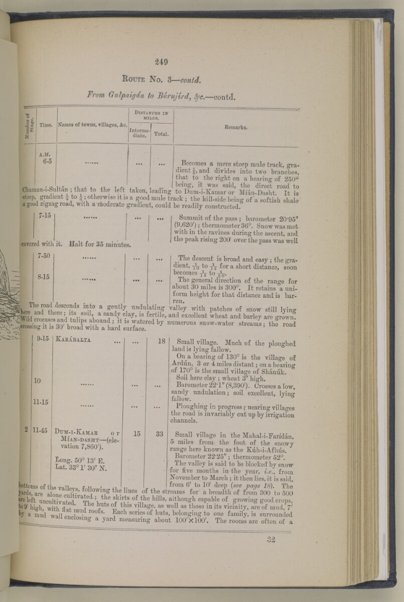
R oute N o.
Prom Qulpaigdn toBunjird, —eontd.
t-i
a; 6£!
vD d
ss
p
Time.
Names of towns, villages, &c.
D istances is -
miles.
Interme
diate.
Total.
Eemarks.
a.m.
--- ^comes a mere steep mule track, gra
dient and divides into two branches,
that to the right on a hearing of 250°
1 ' vlu' 4-1. 4. i. ^ I beirl ^ ^ w as said, the direct road to
€haman-i-Sultan ; that to the left taken, leading to Dum-i-Kamar or Mian-Dasht. It is
steep, gradient ^ to i; otherwise it is a good mule track ; the hill-side being of a softish shale
a good zigzag road, with a moderate gradient, could be readily constructed.
7-15
covered with it. Halt for 35 minutes.
Summit of the pass ; barometer 20-95 /r
(9,620') j thermometer 36°. Snow was met
within the ravines during the ascent, and
the peak rising 200' over the pass was well
7-50
-15
The descent is broad and easy ; the gra
dient, J q to Y2 f or a short distance, soon
becomes to ^
The general direction of the range for
about 30 miles is 300°. It retains a uni
form height for that distance and is bar
ren.
rn i ? v"\ • S&ft aauf cz SiSs
ie road descends into a gently
)-15
10
11-15
11-45
Kaeabalta
Dum-i-Kamae o r
Mian-dasht —(ele
vation 7,860').
Long. 50° 13' E,
Lat. 33° 1' 30 7 N.
18
Small village. Much of the ploughed
land is lying fallow.
On a bearing of 130° is the village of
Ardiin, 3 or 4 miles distant; on a bearing
of 170° is the small village of Shaniik.
Soil here clay ; wheat 3 T/ high.
Barometer 22*1' / (8,390'). Crosses a low,
sandy undulation; soil excellent, Ivins*
fallow. J S
Ploughing in progress; nearing villages
the road is invariably cut up by irrigation
channels.
15 33 Small village in the Mahal-i-Fandan,
5 miles from the foot of the snowy
range here known as the Kiih-i-Afhus.
Barometer 22-25 ,r ; thermometer 52°.
The valley is said to be blocked by snow
for five months in the year, i.e., from
November to March; it then lies, it is said,
bottoms of the valW« -Fniw; L .i ^oni 6' to 10' deep {see page 18). The
y^ds, are alone mlhV ? \ W1 ^ tI I l ® o£ streams for a breadth of from 300 to 500
are left uncultivated. Thehut 6 f /v n hlllS ' ai 1 t 1 hou « l1 ca P ab . le of . growing good crops,
to 9' hi^h with flof ' i" £ ^ ^ village, as well as those in its vicinity, are of mud, 7'
h, „ Wlth roofs. Bach series of huts, belonging to one family, is surrounded
—b", vvitu nat mud
J a mud wall enclosin*
- 7 —^ o ? jlo o u-x 1 w u11u.
a yard measuring about 100'X100'. The rooms are often of
حول هذه المادة
- المحتوى
قرير عسكري عن جنوب غرب بلاد فارس، يتضمن أقاليم خوزستان (عربستان)، لورستان، وجزءًا من فارس بقلم الرائد والبارونيت. المقدم مارك س. بيل، وسام صليب فيكتوريا، فيلق المهندسين الملكي.
بيانات النشر: شيملا: مطبعة الفرع المركزي للحكومة، ١٨٨٥. أُعد في فرع الاستخبارات لإدارة قائد الإمداد والتموين في الهند.
الوصف المادي: ٣ خرائط في جيوب في النهاية. ٤١ لوحة.
- الشكل والحيّز
- مجلد واحد (٣٩٠ صفحة)
- الترتيب
يحتوي هذا المجلد على فهرس محتويات يشمل عناوين الفصول ومراجع الصفحات.
- الخصائص المادية
الأبعاد: ٢٤٥ مم × ١٥٠ مم
- لغة الكتابة
- الإنجليزية بالأحرف اللاتينية للاطّلاع على المعلومات الكاملة لهذا السجل
استخدام وإعادة نشر هذه المادة
- إعادة نشر هذه المادة
"تقرير عسكري عن جنوب غرب بلاد فارس، يتضمن أقاليم خوزستان (عربستان)، لورستان، وجزءًا من فارس" [٢٤٩] (٤٦٦/٢٨٢)و المكتبة البريطانية: مجموعات مطبوعةو V 8685و مكتبة قطر الرقمية <https://www.qdl.qa/archive/81055/vdc_100023694940.0x000051> [تم الوصول إليها في ٢٤ April ٢٠٢٤]
https://www.qdl.qa/العربية/archive/81055/vdc_100023694940.0x000051
يمكنك نسخ ولصق الفقرة التالية لتضمين الصورة في صفحة الويب الخاصة بك.
<meta charset="utf-8"><a href="https://www.qdl.qa/العربية/archive/81055/vdc_100023694940.0x000051">"تقرير عسكري عن جنوب غرب بلاد فارس، يتضمن أقاليم خوزستان (عربستان)، لورستان، وجزءًا من فارس" [<span dir="ltr">٢٤٩</span>] (٤٦٦/٢٨٢)</a> <a href="https://www.qdl.qa/العربية/archive/81055/vdc_100023694940.0x000051"> <img src="https://iiif.qdl.qa/iiif/images/81055/vdc_100023517327.0x000001/V 8685_0304.jp2/full/!280,240/0/default.jpg" alt="" /> </a>
هذا التسجيل IIIF له ملف ظاهر متوفر كما يلي. إذا كان لديك عارض متوافق للصور يمكنك سحب الأيقونة لتحميله.https://www.qdl.qa/العربية/iiif/81055/vdc_100023517327.0x000001/manifestافتح في المتصفح العامافتح في عارض IIIF ميرادورطرق إضافية لاستخدام صور الأرشيف الرقمي
حقوق النسخ والتأليف: كيفية استخدام هذا المحتوى
- رقم الاستدعاء
- V 8685
- العنوان
- "تقرير عسكري عن جنوب غرب بلاد فارس، يتضمن أقاليم خوزستان (عربستان)، لورستان، وجزءًا من فارس"
- الصفحات
- داخلي-خلفي ،٢:١ ،ظ-iv:و-iii ،١٠:١ ،٣٩٠:٣٦٧ ،ن٣٦٦:أ٣٦٦ ،٣٦٦:٣٣٥ ،ب٣٣٤:أ٣٣٤ ،٣٣٤:٢٧٣ ،د٢٧٢:أ٢٧٢ ،٢٧٢:٢٧١ ،ب٢٧٠:أ٢٧٠ ،٢٧٠:٢٦٥ ،ب٢٦٤:أ٢٦٤ ،٢٦٤:٢٥٥ ،ب٢٥٤:أ٢٥٤ ،٢٥٤:٢٥٣ ،ب٢٥٢:أ٢٥٢ ،٢٥٢:٢٤٩ ،ب٢٤٨:أ٢٤٨ ،٢٤٨:٢٤٧ ،ب٢٤٦:أ٢٤٦ ،٢٤٦:٢٤٥ ،د٢٤٤:أ٢٤٤ ،٢٤٤:٢٤١ ،ب٢٤٠:أ٢٤٠ ،٢٤٠:٢٣٧ ،ب٢٣٦:أ٢٣٦ ،٢٣٦:٢٣١ ،ب٢٣٠:أ٢٣٠ ،٢٣٠:٢١٣ ،ب٢١٢:أ٢١٢ ،٢١٢:٢١١ ،ب٢١٠:أ٢١٠ ،٢١٠:٢٠٩ ،د٢٠٨:أ٢٠٨ ،٢٠٨:٢٠٥ ،ب٢٠٤:أ٢٠٤ ،٢٠٤:١٩٣ ،ب١٩٢:أ١٩٢ ،١٩٢:١٩١ ،د١٩٠:أ١٩٠ ،١٩٠:١٨٥ ،ب١٨٤:أ١٨٤ ،١٨٤:١٧٩ ،ب١٧٨:أ١٧٨ ،١٧٨:١٧٧ ،ب١٧٦:أ١٧٦ ،١٧٦:١٦٧ ،ب١١٦:أ١١٦ ،١١٦:١١٣ ،ب١١٢:أ١١٢ ،١١٢:١٠٩ ،ب١٠٨:أ١٠٨ ،١٠٨:٩٩ ،ب٩٨:أ٩٨ ،٩٨:٩٧ ،ب٩٦:أ٩٦ ،٩٦:٦٥ ،ب٦٤:أ٦٤ ،٦٤:٦١ ،ب٦٠:أ٦٠ ،٦٠:٥٥ ،ب٥٤:أ٥٤ ،٥٤:٤١ ،ب٤٠:أ٤٠ ،٤٠:٥ ،ب٤:أ٤ ،٤:٣ ،ب٢:أ٢ ،٢:١ ،٨:١ ،ظ-ii:و-i ،٤:١ ،داخلي-أمامي ،ذيل ،رأس ،حافة ،صلب ،خلفي ،أمامي
- المؤلف
- Bell, Mark Sever
- شروط الاستخدام
- نطاق عام