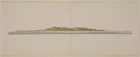
‘Seer Beni Yass dist.t 6 ¼ miles. From a Sketch by Dr. Mackell’
IOR/X/10310/17
2 items in this record
Search within this record
The record is made up of 1 watercolour view. It was created in before 1825. It was written in English. The original is part of the British Library: Map Collections.
About this record
- Content
Distinctive Features:
Watercolour, pen and ink and pencil on paper.
The coastal view drawn by Lieutenant Michael Houghton from a sketch by Dr A. Mackell showing topography of the Seer Beni Yass Island [Sir Bani Yas, United Arab Emirates].
The view was sketched from on board ship and shows the profile of the Seer Beni Yass Island with the latitude reported.
- Extent and format
- 1 watercolour view
- Area map covers
- Map loading...
- Scale
- Scale not given
- Scale designator
- Horizontal
- Orientation
- North
- Degree coordinates
- Top-left: 24° 23' 48.96" N, 52° 29' 59.59" E
Top-right: 24° 23' 48.96" N, 52° 41' 28.14" E
Bottom-left: 24° 13' 32.1" N, 52° 29' 59.59" E
Bottom-right: 24° 13' 32.1" N, 52° 41' 28.14" E - It is part of
- 51 imagesRef: IOR/X/10310
- Physical characteristics
Materials: Pen and ink with wash on paper
Dimensions: 60 x 590 mm
- Written in
- English in Latin script
- Type
- Painting
Archive information for this record
- Original held at
- British Library: Map Collections
- Access conditions
Unrestricted
- Archive reference
- IOR/X/10310/17
- Date(s)
- before 1825 (CE, Gregorian)
Access & Reference
History of this record
Related search terms
- Places
- Seer Beni Yass
Use and share this record
- Share this record
- Cite this record in your research
‘Seer Beni Yass dist.t 6 ¼ miles. From a Sketch by Dr. Mackell’, British Library: Map Collections, IOR/X/10310/17, in Qatar Digital Library <https://www.qdl.qa/archive/81055/vdc_100024196573.0x000004> [accessed 15 May 2024]
- Link to this record
https://www.qdl.qa/en/archive/81055/vdc_100024196573.0x000004
- IIIF details
This record has a IIIF manifest available as follows. If you have a compatible viewer you can drag the icon to load it.https://www.qdl.qa/en/iiif/81055/vdc_100023622982.0x000001/manifestOpen in Universal viewerOpen in Mirador viewerMore options for embedding images
Copyright: How to use this content
- Reference
- IOR/X/10310/17
- Title
- ‘Seer Beni Yass dist.t 6 ¼ miles. From a Sketch by Dr. Mackell’
- Pages
- 18r:18v
- Author
- Houghton, Michael
- Usage terms
- Public Domain