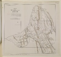
'SKETCH OF THE PROVINCE OF ZOHAB'
IOR/L/PS/10/267, f 217
2 items in this record
Search within this record
The record is made up of 1 map. It was created in 1912. It was written in English. The original is part of the British Library: India Office The department of the British Government to which the Government of India reported between 1858 and 1947. The successor to the Court of Directors. Records and Private Papers Documents collected in a private capacity. .
About this record
- Content
The map originally produced by Colonel Sheil in 1852 shows the various boundary lines in the province of Zohab.
The red dotted line shows the boundary line proposed by the mediating commissioners in 1851, the green dotted line shows the boundary as claimed by the Persian commissioners; the blue dotted line shows the boundary as claimed by the Ottoman commissioners.
The thick black line on the map shows the limits of the map produced by Ely Banister Soane in 1912.
Lithographed A lithograph is an image reproduced from a printing plate whose image areas attract ink and non-image areas repel it. by Harrison & Sons, London.
- Extent and format
- 1 map
- Area map covers
- Map loading...
- Scale
- 3:10
- Scale designator
- Horizontal
- Orientation
- North
- Degree coordinates
- Top-left: 34° 26' 25.69" N, 45° 21' 46.72" E
Top-right: 34° 26' 25.69" N, 45° 28' 3.69" E
Bottom-left: 34° 19' 24.16" N, 45° 21' 46.72" E
Bottom-right: 34° 19' 24.16" N, 45° 28' 3.69" E - It is part of
- File 1356/1912 Pt 2 'Turco-Persian Frontier:- negotiations at Constantinople. (Mohammerah Boundary)'680 imagesRef: IOR/L/PS/10/267
- Physical characteristics
Dimensions: 445mm x 470mm
Materials: 1 paper folio
- Written in
- English in Latin script
- Type
- Map
Archive information for this record
- Original held at
- British Library: India Office The department of the British Government to which the Government of India reported between 1858 and 1947. The successor to the Court of Directors. Records and Private Papers Documents collected in a private capacity.
- Access conditions
Unrestricted
- Archive reference
- IOR/L/PS/10/267, f 217
- Date(s)
- 1912 (CE, Gregorian)
Access & Reference
History of this record
Use and share this record
- Share this record
- Cite this record in your research
'SKETCH OF THE PROVINCE OF ZOHAB', British Library: India Office Records and Private Papers, IOR/L/PS/10/267, f 217, in Qatar Digital Library <https://www.qdl.qa/archive/81055/vdc_100029873665.0x000005> [accessed 30 April 2024]
- Link to this record
https://www.qdl.qa/en/archive/81055/vdc_100029873665.0x000005
- IIIF details
This record has a IIIF manifest available as follows. If you have a compatible viewer you can drag the icon to load it.https://www.qdl.qa/en/iiif/81055/vdc_100000000419.0x0000a0/manifestOpen in Universal viewerOpen in Mirador viewerMore options for embedding images
Copyright: How to use this content
- Reference
- IOR/L/PS/10/267, f 217
- Title
- 'SKETCH OF THE PROVINCE OF ZOHAB'
- Pages
- 217r:217v
- Author
- East India Company, the Board of Control, the India Office, or other British Government Department
- Usage terms
- Open Government Licence