Overview
The IOR/L/MIL Series of the India Office The department of the British Government to which the Government of India reported between 1858 and 1947. The successor to the Court of Directors. Records (IOR) consists of records originally produced by the Military Department of the East India Company (1809-1858), its predecessors and other related bodies, and later by the India Office The department of the British Government to which the Government of India reported between 1858 and 1947. The successor to the Court of Directors. Military Department (1858-1947). These records reflect the full spectrum of the military policy and administration of British India.
The IOR/L/MIL records digitised for the QDL to date are all taken from the Series IOR/L/MIL/5 (Military Compilations and Miscellaneous Records) and IOR/L/MIL/17 (Military Department Library). Over 250 files and volumes from these two series have been digitised, covering the period 1856-1946.
IOR/L/MIL/5: Military Compilations and Miscellaneous Records
Other than two files relating to batta An extra allowance of pay granted to soldiers involved in special field service or to public servants on special duty. paid to British soldiers who served in the Anglo-Persian War of 1856-57 (IOR/L/MIL/5/283-284), and a file covering field telegraph equipment for troops in the Gulf during the same conflict (IOR/L/MIL/5/512), all the records from the IOR/L/MIL/5 Series on the QDL relate to Mesopotamia [Iraq] and Persia [Iran] during and immediately after the First World War. These include:
- Papers relating to the Mesopotamian Commission, set up to investigate the British surrender of Kut in 1916 (IOR/L/MIL/5/768-769, 775 and 777)
- Correspondence of the Marine Transport Department, Mesopotamia (IOR/L/MIL/5/771-773)
- Notes for a ‘Mesopotamia Blue Book’, a British Parliamentary official report on the Mesopotamian Campaign (IOR/L/MIL/5/776)
- Discussions of policy and strategy for the Mesopotamian Campaign (IOR/L/MIL/5/779 and 794)
- Details of specific military units involved in the Mesopotamian Campaign (IOR/L/MIL/5/781-784)
- Papers relating to railways and lines of communication in Mesopotamia (IOR/L/MIL/5/787-790 and 808)
- Papers relating to the Royal Flying Corps (predecessor of the Royal Air Force) in Mesopotamia (IOR/L/MIL/5/793)
- Papers relating to the continued British military occupation of Mesopotamia following the War and the circumstances leading to the Iraqi Revolt of 1920 (IOR/L/MIL/5/795-801)
- Papers relating to British military activity and strategy in Persia in 1917-18 (IOR/L/MIL/5/803-805)
- An India Office The department of the British Government to which the Government of India reported between 1858 and 1947. The successor to the Court of Directors. memorandum and other papers on British military strategy in Persia, India, and Central Asia after the War (IOR/L/MIL/5/806 and 807
IOR/L/MIL/17/5: Indian Army
The IOR/L/MIL/17 Series contains the records of the Military Department’s working reference collection or ‘library’ of official publications, commercially published works, and confidential prints. The material from this Series on the QDL comes from three subseries: IOR/L/MIL/17/5 (Indian Army); IOR/L/MIL/17/15 (Iran, Iraq, Persian Gulf The historical term used to describe the body of water between the Arabian Peninsula and Iran. ); and IOR/L/MIL/17/16 (Arabia, Syria, Turkey, Cyprus).
The IOR/L/MIL/17/5 Subseries contains published reference materials relating to the Indian Army, 1854-1947. Material from this Subseries currently on the QDL consists primarily of 64 volumes (several of which are divided into two parts) of War Diaries (IOR/L/MIL/17/5/3223-3328). These detail the activities of the Indian Expeditionary Force D, also known as the Mesopotamia Expeditionary Force, September 1914-November 1919. In addition, there are two volumes of General Routine Orders (IOR/L/MIL/17/5/3328A) issued to Force D, December 1915-July 1918.

IOR/L/MIL/17/15: Iran, Iraq, Persian Gulf
Records relating to Persia from this Subseries include:
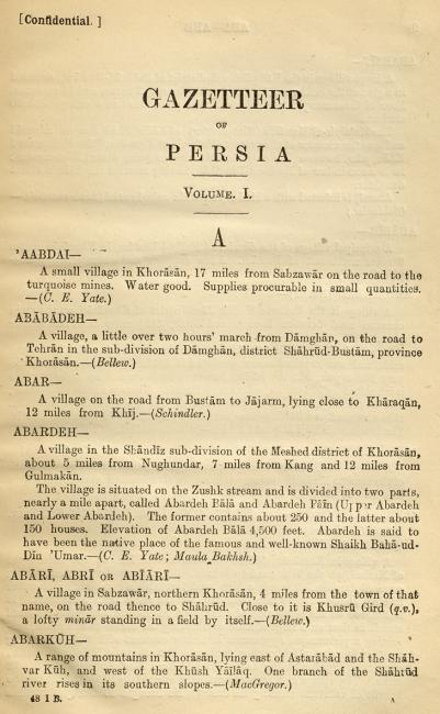
- Gazetteer of Persia (IOR/L/MIL/17/15/1-4), a four-volume alphabetical guide to places throughout Persia, giving information on villages, towns, administrative divisions, tribes, religious sects, physical features, history, communications, agriculture, population, water supply, trade, politics, and related matters. The sources for the information are cited in brackets at the end of each entry, and volumes are available from three editions dated 1885-1918
- Military Reports on Persia (IOR/L/MIL/17/15/5-10), dated 1900-31, consisting of handbooks of military intelligence, which also give information on history, geography, and politics
- Routes in Persia (IOR/L/MIL/17/15/12), which provides details of land routes between given locations. Information provided includes the source for the details given, the distance, and remarks on topography, settlements, local people, water, and supplies. The publication dates cover 1916-28. There is also a later volume dated 1942, giving details of motor transport routes (IOR/L/MIL/17/15/13)
- The four-volume Who’s Who in Persia, which provides a biographical dictionary of individuals in the region, published 1923-24 (IOR/L/MIL/17/15/11/1-8)
- Individual reports and official publications relating to regions of Persia, including Arabistan [Khuzestan] (IOR/L/MIL/17/15/15-16), Fars (IOR/L/MIL/17/15/18), Kermanshah (IOR/L/MIL/17/15/19), and Kurdistan (IOR/L/MIL/17/15/21-22)
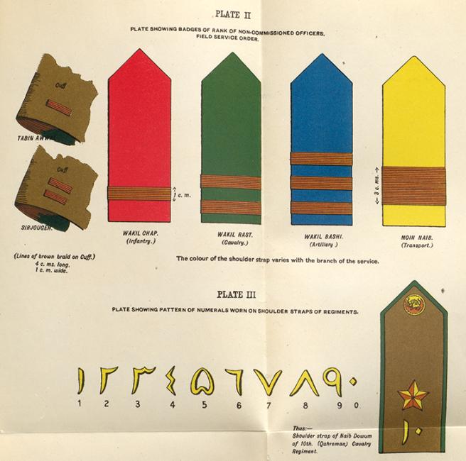
- Individual reports and official publications relating to military matters in Persia, including reports on military operations in Persia during the First World War (IOR/L/MIL/17/15/28-36), a Handbook of the Persian Army, 1925 (IOR/MIL/17/15/37), a Glossary of Persian Military Terms, 1926 (IOR/L/MIL/17/15/38), and reports relating to Persia during the Second World War (IOR/L/MIL/17/15/24, 39, and 40)
Records relating to Iraq include:
- A Handbook of Mesopotamia, in four volumes, published 1916-18 (IOR/L/MIL/17/15/41/1-6), giving similar information to the military intelligence works on Persia mentioned above, with maps
- Military Reports on Mesopotamia (Iraq), 1922-36 (IOR/L/MIL/17/15/42-47)
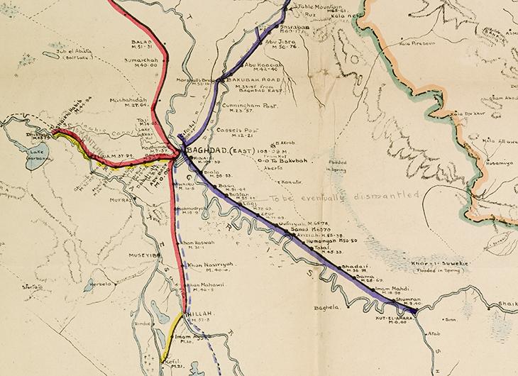
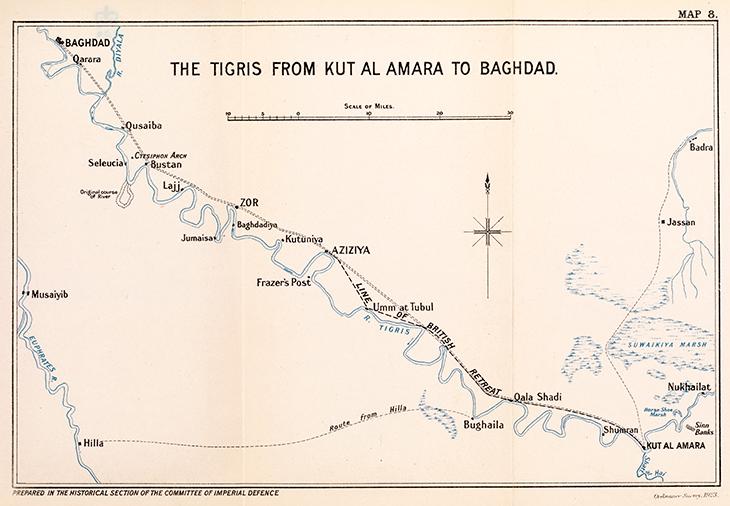
- Field Notes on Mesopotamia, 1914-17 (IOR/L/MIL/17/15/48-50), and other reports relating to Iraq during the First World War (IOR/L/MIL/17/15/55, 72 and 125), including a four-volume official history of the Campaign in Mesopotamia, 1914-18, with numerous maps (IOR/L/MIL/17/15/66/1-4)
- Who’s Who in Mesopotamia, 1916 (IOR/L/MIL/17/15/51)
- Individual reports, including reports on air and motorcar operations along the Iraq-Najd border in 1927-29 (IOR/L/MIL/17/15/62-63)
- A Naval Intelligence report on Iraq and the Persian Gulf The historical term used to describe the body of water between the Arabian Peninsula and Iran. , 1944 (IOR/L/MIL/17/5/64), covering geography, meteorology, history, culture, government, and economy, and containing over 300 maps, diagrams and illustrations
There are fewer records relating to the Arabian littoral of the Gulf, reflecting its lower military and strategic importance to Britain during these years. However, the Military Report on the Arabian Shores of the Persian Gulf The historical term used to describe the body of water between the Arabian Peninsula and Iran. , Kuwait, Bahrein [Bahrain], Hasa [Al-Ahsa], Qatar, Trucial Oman A name used by Britain from the nineteenth century to 1971 to refer to the present-day United Arab Emirates. and Oman (IOR/L/MIL/17/15/141), published in 1933, contains information on history, geography, climate, health, population, water supply, resources, armed forces, aviation, political affairs, wireless and telegraph communications, land routes, currency, weights and measures, and maritime landing facilities, and includes five maps. The five-volume Gazetteer of the Persian Gulf The historical term used to describe the body of water between the Arabian Peninsula and Iran. , 1908-1915, falls within this Subseries, but is included on the QDL under a separate Series as IOR/L/PS/20/C91/1-4.
The Subseries also includes a translation dictionary listing basic words and phrases in English, Arabic, Persian, Turkish, Armenian, Kurdish, and Syriac (IOR/L/MIL/17/15/52).
IOR/L/MIL/17/16: Arabia, Syria, Turkey, Cyprus
Records relating to the Arabian Peninsula in this Subseries include:
- A three-volume Gazetteer of Arabia, 1917, consisting of an alphabetically-arranged compendium of the tribes and geographical features of the Arabian Peninsula. The information is based on official sources, (some restricted or secret) travellers’ books, and official and ‘native’ [non-European] informants, with sources occasionally given in brackets at the end of entries. The Gazetteer has been criticised for the unreliability of its transliterations of Arabic names, and for factual errors, but much of the information remains interesting and valuable (IOR/L/MIL/17/16/2/1-3)
- Routes in Arabia, 1915, detailing the ‘more important of the known routes’ on the peninsula, with an illustrative map (IOR/L/MIL/17/16/3)
- A Naval Intelligence report on Arabia, 1941 (IOR/L/MIL/17/16/5)
- Reports on subjects relating to Aden, including the defences of Aden and Perim Island, neighbouring tribes, and operations of the Aden Field Force during the First World War (IOR/L/MIL/17/16/8-11)
- A Handbook of Hejaz, 1917, prepared by the Arab Bureau, Cairo, and describing the geography, population, politics, and trade of the Kingdom of Hejaz (IOR/L/MIL/17/16/12) and a ‘Summary of the Hejaz revolt’ (IOR/L/MIL/17/16/13)
- A Handbook of Yemen, also from the Arab Bureau, Cairo (IOR/L/MIL/17/16/14)
The two-volume Handbook of Arabia, 1917, falls within this Subseries, but is included on the QDL under a separate Series as IOR/L/PS/20/E84/1-2.

Records relating to Turkey include:
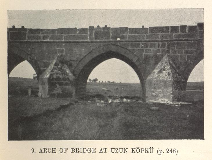
- A Handbook of Turkey in Europe, 1917, which provides a detailed description of the East Thrace region of Turkey, illustrated by several photographs and a map (IOR/L/MIL/17/16/17)
- Narrative of Circumstances which Led to Major-Gen Beatson being Relieved from the Command of the Turkish Irregular Cavalry [etc.], 1856 (IOR/L/MIL/17/16/18)
- Reports from the Russo-Turkish War of 1877, including two maps (IOR/L/MIL/17/16/19-20)
- A report on German newspaper coverage of ‘the military strength of Turkey’, 1893 (IOR/L/MIL/17/16/21)
- Reports from 1917-18 on the Pan-Turanian and Pan-Turkish movements
The Subseries also contains: a Handbook of Syria (including Palestine), 1919 (IOR/L/MIL/17/16/15); a report on ‘Military Lessons of the Arab Rebellion in Palestine’, 1936 (IOR/L/MIL/17/16/16); and two relating to Cyprus, from 1878 and 1936 respectively (IOR/L/MIL/17/16/28-29).
The QDL’s IOR/L/MIL files as a whole are an invaluable resource for British military and political intelligence on the region, particularly in the period 1900 to the mid-1930s, and are an excellent source for maps.