Historical maps of Hormúz Island
IOR/X/3127
2 items in this record
Search within this record
The record is made up of 3 maps and 1 view on 1 sheet. It was created in 1874. It was written in English and Latin. The original is part of the British Library: Map Collections.
About this record
- Content
Imprint:
London, T. Pettitt & Co. Litho.
Distinctive Features:
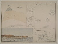
Map in the upper left:
'North end of Hormúz Island shewing site of ancient towns &c.’.
Map in the upper right:
'Map shewing the position of Hormúz Island with reference to the Persian Coast and the other old European settlements in the vicinity. From actual survey by A.W. Stiffe, late Lieut. R.N.'
View in the lower left:
'Portuguese fort on Hormúz Island, old minaret on the left.'
Map in the lower right:
'Isld. of Harmúz or Ormus. Bird's-eye view of Hormúz from “Astley's" collection’
Includes Latin text in the upper centre: ‘A ESTA SEPHEDESI MAORO 13 DEFAR IAE DESVAMOL HERE HERDROS FALECEOEILEA A.Z. DEABRILDE BOIEILA A8DEE EVRODE B03’. And below: ‘SEPVTRA DE AMTONO CO REA E DE SEVS IR DEIROS FALE SEO AOS 17 DE IANE IRO DE 1591 ANNOS’. With skull and crossbones at the bottom.
Inscriptions:
On recto The front of a sheet of paper or leaf, often abbreviated to 'r'. , top margin in the right-hand corner: ‘Geographical Magazine’ and 'April 1874'.
- Extent and format
- 3 maps and 1 view on 1 sheet
- Area map covers
- Map loading...
- Scale
- differ
- Scale designator
- Horizontal
- Orientation
- North
- Degree coordinates
- Top-left: 27° 6' 8.98" N, 56° 25' 12.96" E
Top-right: 27° 6' 8.98" N, 56° 30' 7.93" E
Bottom-left: 27° 1' 58.56" N, 56° 25' 12.96" E
Bottom-right: 27° 1' 58.56" N, 56° 30' 7.93" E - Physical characteristics
Dimensions: 260 x 240 mm or smaller, on sheet 430 x 570 mm
- Written in
- English and Latin in Latin script
- Type
- Map
Archive information for this record
- Original held at
- British Library: Map Collections
- Access conditions
Unrestricted
- Archive reference
- IOR/X/3127
- Former external reference(s)
- M.V.37
- Date(s)
- 1874 (CE, Gregorian)
Access & Reference
History of this record
Related material
Related search terms
- Places
- Hormuz Isle
- People & organisations
- T. Pettitt and Co.Arthur William Stiffe
Use and share this record
- Share this record
- Cite this record in your research
Historical maps of Hormúz Island, British Library: Map Collections, IOR/X/3127, in Qatar Digital Library <https://www.qdl.qa/archive/81055/vdc_100000006836.0x000001> [accessed 6 June 2026]
- Link to this record
https://www.qdl.qa/en/archive/81055/vdc_100000006836.0x000001
- IIIF details
This record has a IIIF manifest available as follows. If you have a compatible viewer you can drag the icon to load it.https://www.qdl.qa/en/iiif/81055/vdc_100000006836.0x000001/manifestOpen in Universal viewerOpen in Mirador viewerMore options for embedding images
Copyright: How to use this content
- Reference
- IOR/X/3127
- Title
- Historical maps of Hormúz Island
- Pages
- 1r:1v
- Author
- Unknown
- Usage terms
- Public Domain