![‘South Arabia. Anglo-Turkish Boundary. Sheet No. 2’ [‎38r] (1/2)](https://iiif.qdl.qa/iiif/images/81055/vdc_100000000193.0x0002cc/IOR_R_15_1_741_0089.jp2/full/!1200,1200/0/default.jpg "‘South Arabia. Anglo-Turkish Boundary. Sheet No. 2’ [‎38r] (1/2)")
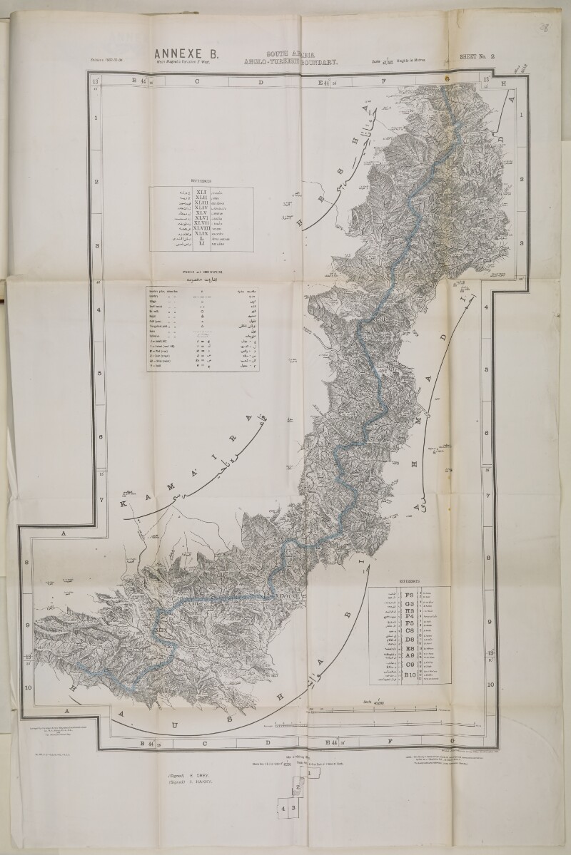
‘South Arabia. Anglo-Turkish Boundary. Sheet No. 2’ [38r] (1/2)
The record is made up of 1 map. It was created in 1914. It was written in English. The original is part of the British Library: India Office The department of the British Government to which the Government of India reported between 1858 and 1947. The successor to the Court of Directors. Records and Private Papers Documents collected in a private capacity. .
About this item
- Content
Imprint:
Printed at the Ordnance Survey Office, Southampton, 1914. Surveyed by the Anglo-Turkish Boundary Commission under Colonel R.A. Wahab, C.I.E., R.E. and Colonel Mustapha Remzi Bey. Signed by Sir Edward Grey and Ibrahim Hakki Pasha An Ottoman title used after the names of certain provincial governors, high-ranking officials and military commanders. .
Distinctive Features:
Relief shown by contours and spot heights A point on a map at which the height of the land is recorded. .
Map issued as an Annex B to Anglo-Ottoman Convention of 3 June 1914. The line of demarcation of the boundary determined to separate the Yemen from the territory of the nine cantons of Aden shown in blue. Areas marked with Roman numerals are listed in table of reference and described in main body of the document.
Map's borders are lettered and numbered for reference with tables and a key to symbols and abbreviations in both English and Arabic. Includes index to adjoining sheets and a note on the survey’s sources.
- Extent and format
- 1 map
- Area map covers
- Map loading...
- Scale
- Scale approximately 1:40,000
- Scale designator
- Horizontal
- Orientation
- North
- Degree coordinates
- Top-left: 13° 45' 11.27" N, 44° 20' 5.71" E
Top-right: 13° 45' 11.27" N, 44° 45' 29.22" E
Bottom-left: 13° 25' 13.16" N, 44° 20' 5.71" E
Bottom-right: 13° 25' 13.16" N, 44° 45' 29.22" E - Physical characteristics
Dimensions:
676 x 590 mm, on sheet 988 x 656 mm
- Written in
- English in Latin script View the complete information for this record
Use and share this item
- Share this item
‘South Arabia. Anglo-Turkish Boundary. Sheet No. 2’ [38r] (1/2), British Library: India Office Records and Private Papers, IOR/R/15/1/741, f 38, in Qatar Digital Library <https://www.qdl.qa/archive/81055/vdc_100022752333.0x000053> [accessed 25 June 2026]
https://www.qdl.qa/en/archive/81055/vdc_100022752333.0x000053
Copy and paste the code below into your web page where you would like to embed the image.
<meta charset="utf-8"><a href="https://www.qdl.qa/en/archive/81055/vdc_100022752333.0x000053">‘South Arabia. Anglo-Turkish Boundary. Sheet No. 2’ [‎38r] (1/2)</a> <a href="https://www.qdl.qa/en/archive/81055/vdc_100022752333.0x000053"> <img src="https://iiif.qdl.qa/iiif/images/81055/vdc_100000000193.0x0002cc/IOR_R_15_1_741_0089.jp2/full/!280,240/0/default.jpg" alt="" /> </a>
This record has a IIIF manifest available as follows. If you have a compatible viewer you can drag the icon to load it.https://www.qdl.qa/en/iiif/81055/vdc_100000000193.0x0002cc/manifestOpen in Universal viewerOpen in Mirador viewerMore options for embedding images
Copyright: How to use this content
- Reference
- IOR/R/15/1/741, f 38
- Title
- ‘South Arabia. Anglo-Turkish Boundary. Sheet No. 2’
- Pages
- 38r:38v
- Author
- East India Company, the Board of Control, the India Office, or other British Government Department
- Usage terms
- Open Government Licence