![Blueprint showing position of pearl banks on Trucial Coast [‎11r] (1/2)](https://iiif.qdl.qa/iiif/images/81055/vdc_100000000193.0x00024d/IOR_R_15_1_616_0022.jp2/full/!1200,1200/0/default.jpg "Blueprint showing position of pearl banks on Trucial Coast [‎11r] (1/2)")
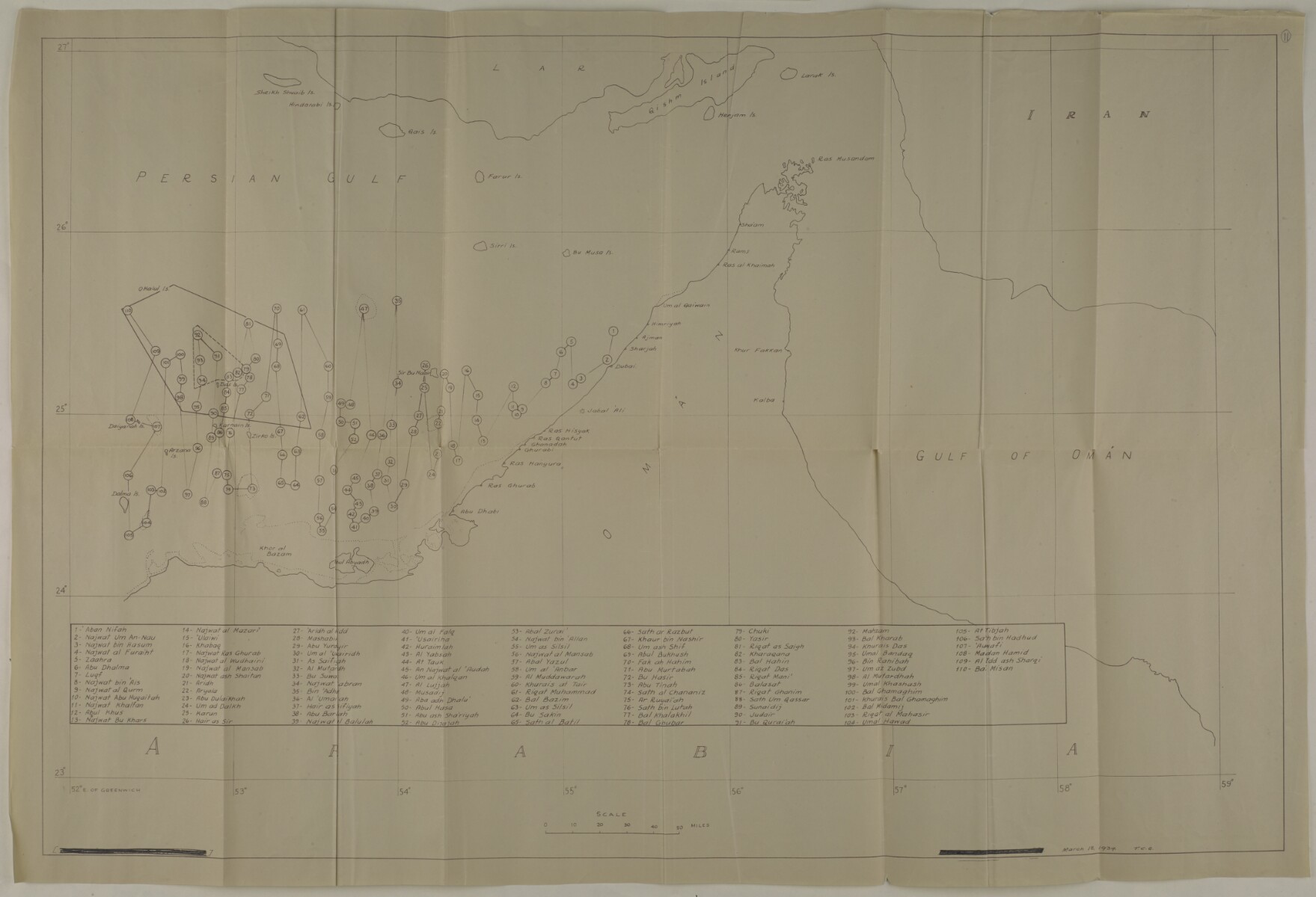
Blueprint showing position of pearl banks on Trucial Coast [11r] (1/2)
The record is made up of 1 map. It was created in 18 Mar 1939. It was written in English. The original is part of the British Library: India Office The department of the British Government to which the Government of India reported between 1858 and 1947. The successor to the Court of Directors. Records and Private Papers Documents collected in a private capacity. .
About this item
- Content
Distinctive Features:
Each of the pearl banks marked with a number. Shores not covered by water at low tide indicated by dotted lines. Includes a key which lists the names of the 110 numbered pearl banks in transliterated English.
Above neat line at the bottom left-hand corner and centre illegible details obscured by smudged ink (probably imprint), followed by: ‘March 18, 1939. T.C.G’.
- Extent and format
- 1 map
- Area map covers
- Map loading...
- Scale
- Scale not given
- Scale designator
- Horizontal
- Orientation
- North
- Degree coordinates
- Top-left: 27° 0' 7.92" N, 52° 2' 18.24" E
Top-right: 27° 0' 7.92" N, 59° 0' 44.64" E
Bottom-left: 23° 0' 36" N, 52° 2' 18.24" E
Bottom-right: 23° 0' 36" N, 59° 0' 44.64" E - Physical characteristics
Dimensions:
500 x 821 mm, on sheet 593 x 890 mm
- Written in
- English in Latin script View the complete information for this record
Use and share this item
- Share this item
Blueprint showing position of pearl banks on Trucial Coast [11r] (1/2), British Library: India Office Records and Private Papers, IOR/R/15/1/616, f 11, in Qatar Digital Library <https://www.qdl.qa/archive/81055/vdc_100023403859.0x000016> [accessed 25 April 2024]
https://www.qdl.qa/en/archive/81055/vdc_100023403859.0x000016
Copy and paste the code below into your web page where you would like to embed the image.
<meta charset="utf-8"><a href="https://www.qdl.qa/en/archive/81055/vdc_100023403859.0x000016">Blueprint showing position of pearl banks on Trucial Coast [‎11r] (1/2)</a> <a href="https://www.qdl.qa/en/archive/81055/vdc_100023403859.0x000016"> <img src="https://iiif.qdl.qa/iiif/images/81055/vdc_100000000193.0x00024d/IOR_R_15_1_616_0022.jp2/full/!280,240/0/default.jpg" alt="" /> </a>
This record has a IIIF manifest available as follows. If you have a compatible viewer you can drag the icon to load it.https://www.qdl.qa/en/iiif/81055/vdc_100000000193.0x00024d/manifestOpen in Universal viewerOpen in Mirador viewerMore options for embedding images
Copyright: How to use this content
- Reference
- IOR/R/15/1/616, f 11
- Title
- Blueprint showing position of pearl banks on Trucial Coast
- Pages
- 11r:11v
- Author
- Unknown
- Usage terms
- The copyright status is unknown. Please contact copyright@bl.uk with any information you have regarding this item.