![Map of the Persian Gulf showing aerodromes and refuelling facilities on Arab and Persian coasts [‎194r] (1/2)](https://iiif.qdl.qa/iiif/images/81055/vdc_100000000193.0x0003e6/IOR_R_15_2_263_0416.jp2/full/!1200,1200/0/default.jpg "Map of the Persian Gulf showing aerodromes and refuelling facilities on Arab and Persian coasts [‎194r] (1/2)")
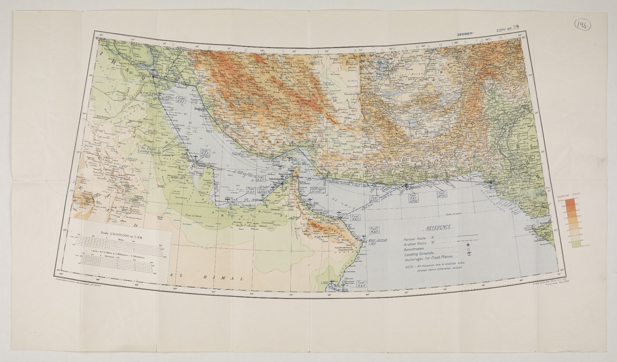
Map of the Persian Gulf showing aerodromes and refuelling facilities on Arab and Persian coasts [194r] (1/2)
The record is made up of 1 map. It was created in Nov 1933. It was written in English. The original is part of the British Library: India Office The department of the British Government to which the Government of India reported between 1858 and 1947. The successor to the Court of Directors. Records and Private Papers Documents collected in a private capacity. .
About this item
- Content
Imprint:
Printed at the War Office, Oct. 1928. Overprinted, Nov. 1933. Geographical Section, General Staff, No. 3869A.
Distinctive Features:
Relief shown by gradient tints and spot heights A point on a map at which the height of the land is recorded. .
Map of the Persian Gulf The historical term used to describe the body of water between the Arabian Peninsula and Iran. region showing air routes with aerodromes, landing grounds and anchorages for float planes indicated by symbols and a key provided at the bottom right. Distances reported.
‘Secret’ crossed out with blue crayon and a copy number ‘29’ inserted in black ink, in the top right of sheet above neat line.
- Extent and format
- 1 map
- Area map covers
- Map loading...
- Scale
- Scale approximately 1:4,000,000
- Scale designator
- Horizontal
- Orientation
- North
- Degree coordinates
- Top-left: 32° 19' 12" N, 44° 0' 36" E
Top-right: 32° 19' 12" N, 70° 2' 60" E
Bottom-left: 21° 24' 36" N, 44° 0' 36" E
Bottom-right: 21° 24' 36" N, 70° 2' 60" E - Physical characteristics
Dimensions: 332 x 700 mm, on sheet 482 x 845 mm
- Written in
- English in Latin script View the complete information for this record
Use and share this item
- Share this item
Map of the Persian Gulf showing aerodromes and refuelling facilities on Arab and Persian coasts [194r] (1/2), British Library: India Office Records and Private Papers, IOR/R/15/2/263, f 194, in Qatar Digital Library <https://www.qdl.qa/archive/81055/vdc_100023518692.0x000002> [accessed 3 July 2026]
https://www.qdl.qa/en/archive/81055/vdc_100023518692.0x000002
Copy and paste the code below into your web page where you would like to embed the image.
<meta charset="utf-8"><a href="https://www.qdl.qa/en/archive/81055/vdc_100023518692.0x000002">Map of the Persian Gulf showing aerodromes and refuelling facilities on Arab and Persian coasts [‎194r] (1/2)</a> <a href="https://www.qdl.qa/en/archive/81055/vdc_100023518692.0x000002"> <img src="https://iiif.qdl.qa/iiif/images/81055/vdc_100000000193.0x0003e6/IOR_R_15_2_263_0416.jp2/full/!280,240/0/default.jpg" alt="" /> </a>
This record has a IIIF manifest available as follows. If you have a compatible viewer you can drag the icon to load it.https://www.qdl.qa/en/iiif/81055/vdc_100000000193.0x0003e6/manifestOpen in Universal viewerOpen in Mirador viewerMore options for embedding images
Copyright: How to use this content
- Reference
- IOR/R/15/2/263, f 194
- Title
- Map of the Persian Gulf showing aerodromes and refuelling facilities on Arab and Persian coasts
- Pages
- 194r:194v
- Author
- East India Company, the Board of Control, the India Office, or other British Government Department
- Usage terms
- Open Government Licence