![Sketch map of Al Aflaj region in Saudi Arabia [‎22r] (1/2)](https://iiif.qdl.qa/iiif/images/81055/vdc_100000000193.0x0001dd/IOR_R_15_1_504_0050.jp2/full/!1200,1200/0/default.jpg "Sketch map of Al Aflaj region in Saudi Arabia [‎22r] (1/2)")
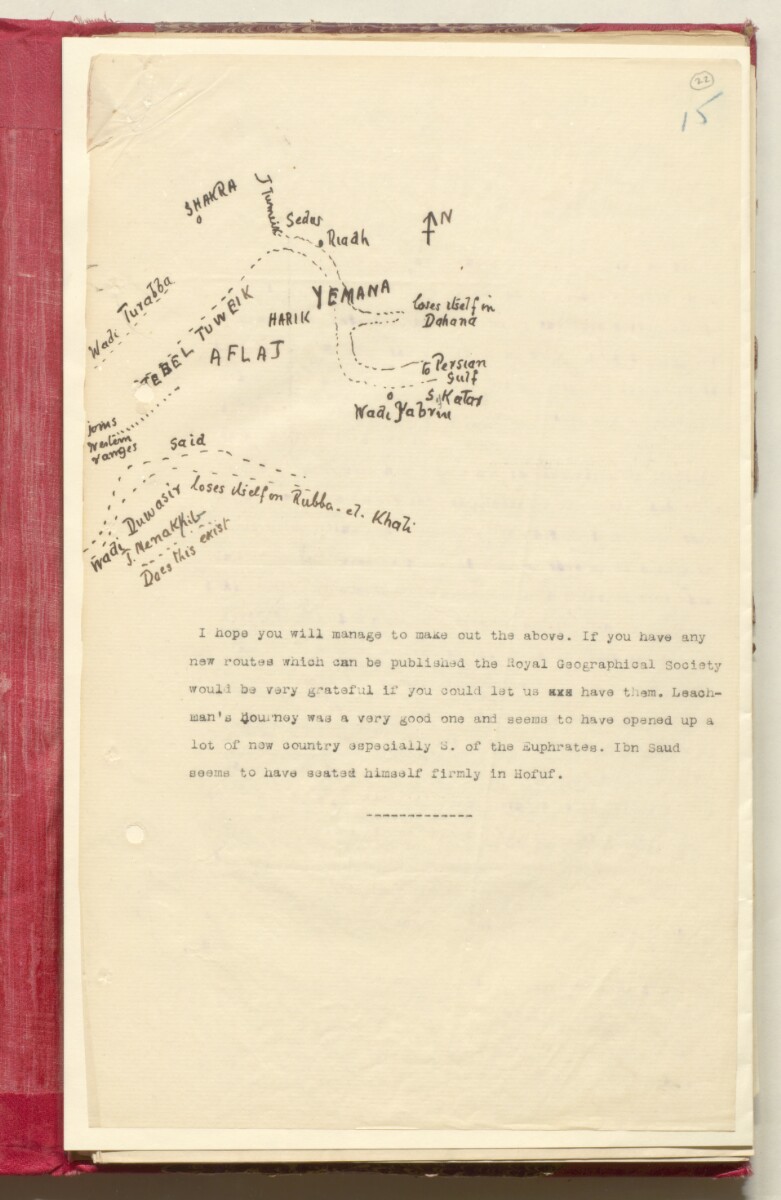
Sketch map of Al Aflaj region in Saudi Arabia [22r] (1/2)
The record is made up of 1 map. It was created in 1913. It was written in English. The original is part of the British Library: India Office The department of the British Government to which the Government of India reported between 1858 and 1947. The successor to the Court of Directors. Records and Private Papers Documents collected in a private capacity. .
About this item
- Content
Distinctive Features:
Hand drawn rough sketch map of Al Aflaj region south west of Riyadh, sent with a copy of a letter dated 17th October 1913 from Colonel F.R. Maunsell to Sir Percy Zachariah Cox with a request to provide the most current information on routes within the region. The information required for compilation of map of Northern Arabia showing Captain Leadhman’s journey from Damascus to Riadh, produced by the Royal Geographical Society.
- Extent and format
- 1 map
- Area map covers
- Map loading...
- Scale
- Scale not given
- Scale designator
- Horizontal
- Orientation
- North
- Degree coordinates
- Top-left: 25° 22' 10.2" N, 45° 6' 21.96" E
Top-right: 25° 22' 10.2" N, 49° 7' 16.32" E
Bottom-left: 22° 42' 46.08" N, 45° 6' 21.96" E
Bottom-right: 22° 42' 46.08" N, 49° 7' 16.32" E - Physical characteristics
Materials: Pen and ink on paper
Dimensions: 150 x 200 mm, on sheet 327 x 200 mm
- Written in
- English in Latin script View the complete information for this record
Use and share this item
- Share this item
Sketch map of Al Aflaj region in Saudi Arabia [22r] (1/2), British Library: India Office Records and Private Papers, IOR/R/15/1/504, f 22, in Qatar Digital Library <https://www.qdl.qa/archive/81055/vdc_100023613995.0x000032> [accessed 16 June 2024]
https://www.qdl.qa/en/archive/81055/vdc_100023613995.0x000032
Copy and paste the code below into your web page where you would like to embed the image.
<meta charset="utf-8"><a href="https://www.qdl.qa/en/archive/81055/vdc_100023613995.0x000032">Sketch map of Al Aflaj region in Saudi Arabia [‎22r] (1/2)</a> <a href="https://www.qdl.qa/en/archive/81055/vdc_100023613995.0x000032"> <img src="https://iiif.qdl.qa/iiif/images/81055/vdc_100000000193.0x0001dd/IOR_R_15_1_504_0050.jp2/full/!280,240/0/default.jpg" alt="" /> </a>
This record has a IIIF manifest available as follows. If you have a compatible viewer you can drag the icon to load it.https://www.qdl.qa/en/iiif/81055/vdc_100000000193.0x0001dd/manifestOpen in Universal viewerOpen in Mirador viewerMore options for embedding images
Copyright: How to use this content
- Reference
- IOR/R/15/1/504, f 22
- Title
- Sketch map of Al Aflaj region in Saudi Arabia
- Pages
- 22r:22v
- Author
- East India Company, the Board of Control, the India Office, or other British Government Department
- Usage terms
- Open Government Licence