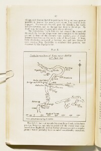
‘Plan 5 showing probable position of Turks near Rota, 21st Jan. 1915’
IOR/L/MIL/17/15/73, p 42
1 items in this record
Search within this record
The record is made up of 1 map. It was created in 1921. It was written in English. The original is part of the British Library: India Office The department of the British Government to which the Government of India reported between 1858 and 1947. The successor to the Court of Directors. Records and Private Papers Documents collected in a private capacity. .
About this record
- Content
Distinctive Features:
Rough sketch showing the Tigris River near Rota [Ar Rawtah] drawn from plan prepared by G.S. India showing the position of British and Arab forces, including the location of camps, trenches and guns.
- Extent and format
- 1 map
- Area map covers
- Map loading...
- Scale
- Scale not given
- Scale designator
- Horizontal
- Orientation
- North
- Degree coordinates
- Top-left: 31° 9' 18.84" N, 47° 25' 6.12" E
Top-right: 31° 9' 18.84" N, 47° 29' 4.04" E
Bottom-left: 31° 5' 40.88" N, 47° 25' 6.12" E
Bottom-right: 31° 5' 40.88" N, 47° 29' 4.04" E - It is part of
- 150 imagesRef: IOR/L/MIL/17/15/73
- Physical characteristics
Dimensions: 121 x 109 mm, on sheet 245 x 152 mm
- Written in
- English in Latin script
- Type
- Map
Archive information for this record
- Original held at
- British Library: India Office The department of the British Government to which the Government of India reported between 1858 and 1947. The successor to the Court of Directors. Records and Private Papers Documents collected in a private capacity.
- Access conditions
Unrestricted
- Archive reference
- IOR/L/MIL/17/15/73, p 42
- Date(s)
- 1921 (CE, Gregorian)
Access & Reference
History of this record
Use and share this record
- Share this record
- Cite this record in your research
‘Plan 5 showing probable position of Turks near Rota, 21st Jan. 1915’, British Library: India Office Records and Private Papers, IOR/L/MIL/17/15/73, p 42, in Qatar Digital Library <https://www.qdl.qa/archive/81055/vdc_100023824113.0x000003> [accessed 21 May 2024]
- Link to this record
https://www.qdl.qa/en/archive/81055/vdc_100023824113.0x000003
- IIIF details
This record has a IIIF manifest available as follows. If you have a compatible viewer you can drag the icon to load it.https://www.qdl.qa/en/iiif/81055/vdc_100000000239.0x00018d/manifestOpen in Universal viewerOpen in Mirador viewerMore options for embedding images
Copyright: How to use this content
- Reference
- IOR/L/MIL/17/15/73, p 42
- Title
- ‘Plan 5 showing probable position of Turks near Rota, 21st Jan. 1915’
- Pages
- 42
- Author
- East India Company, the Board of Control, the India Office, or other British Government Department
- Usage terms
- Open Government Licence