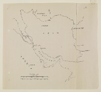
A sketch map of Persian Gulf region for use in clerical examination
IOR/R/15/2/1022, f 76
2 items in this record
Search within this record
The record is made up of 1 map. It was created in c 1936-1939. It was written in English. The original is part of the British Library: India Office The department of the British Government to which the Government of India reported between 1858 and 1947. The successor to the Court of Directors. Records and Private Papers Documents collected in a private capacity. .
About this record
- Content
Distinctive Features:
First of four identical copies (folios 76, 90, 99 and 111c) contained within this file. This copy has five place names added in pencil.
- Extent and format
- 1 map
- Area map covers
- Map loading...
- Scale
- Scale approximately 1:10,000,000
- Scale designator
- Horizontal
- Orientation
- North
- Degree coordinates
- Top-left: 40° 0' 36" N, 40° 40' 12" E
Top-right: 40° 0' 36" N, 63° 46' 48" E
Bottom-left: 19° 57' 36" N, 40° 40' 12" E
Bottom-right: 19° 57' 36" N, 63° 46' 48" E - It is part of
- 324 imagesRef: IOR/R/15/2/1022
- Physical characteristics
Dimensions: 256 x 282 mm
- Written in
- English in Latin script
- Type
- Map
Archive information for this record
- Original held at
- British Library: India Office The department of the British Government to which the Government of India reported between 1858 and 1947. The successor to the Court of Directors. Records and Private Papers Documents collected in a private capacity.
- Access conditions
Unrestricted
- Archive reference
- IOR/R/15/2/1022, f 76
- Date(s)
- c 1936-1939 (CE, Gregorian)
Access & Reference
History of this record
Use and share this record
- Share this record
- Cite this record in your research
A sketch map of Persian Gulf region for use in clerical examination, British Library: India Office Records and Private Papers, IOR/R/15/2/1022, f 76, in Qatar Digital Library <https://www.qdl.qa/archive/81055/vdc_100024075035.0x000001> [accessed 28 April 2024]
- Link to this record
https://www.qdl.qa/en/archive/81055/vdc_100024075035.0x000001
- IIIF details
This record has a IIIF manifest available as follows. If you have a compatible viewer you can drag the icon to load it.https://www.qdl.qa/en/iiif/81055/vdc_100000000241.0x000245/manifestOpen in Universal viewerOpen in Mirador viewerMore options for embedding images
Copyright: How to use this content
- Reference
- IOR/R/15/2/1022, f 76
- Title
- A sketch map of Persian Gulf region for use in clerical examination
- Pages
- 76r:76v
- Author
- East India Company, the Board of Control, the India Office, or other British Government Department
- Usage terms
- Open Government Licence