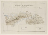
'MAP OF THE COUNTRY ON BOTH SIDES OF THE BOUNDARY LINE DRAWN BY THE JOINT COMMISSION FOR DELIMITING THE RUSSIAN AND AFGHAN TERRITORIES ON THE PAMIRS 1895.'
Mss Eur F111/68, f 28
2 items in this record
Search within this record
The record is made up of 1 map. It was created in Apr 1896. It was written in English. The original is part of the British Library: India Office The department of the British Government to which the Government of India reported between 1858 and 1947. The successor to the Court of Directors. Records and Private Papers Documents collected in a private capacity. .
About this record
- Content
Map showing the land lying immediately north and south of the boundary line drawn by the Joint Commission for delimiting the Russian and Afghan territories along the Pamir mountain range. As well as showing the boundary (highlighted in green and pink ink) the map provides some indication of relief and hydrology. Below the map is a table of reference for symbols used on the map, as well as the respective signatures of the commissioners for Great Britain and Russia.
The map includes the following statement: 'Reduced from the original map on the scale of 1 inch to 5 versts signed by the commissioners.' Below the map is another signature: that of Major General John Charles Ardagh, Director of Military Intelligence, certifying that the map truly represents the original.
- Extent and format
- 1 map
- Area map covers
- Map loading...
- Scale
- 1:253440
- Scale designator
- Horizontal
- Orientation
- North
- Degree coordinates
- Top-left: 37° 59' 53.98" N, 73° 33' 32.26" E
Top-right: 37° 59' 53.98" N, 76° 19' 39.05" E
Bottom-left: 37° 6' 51.61" N, 73° 33' 32.26" E
Bottom-right: 37° 6' 51.61" N, 76° 19' 39.05" E - It is part of
- 202 imagesRef: Mss Eur F111/68
- Physical characteristics
Materials: Printed in colour on paper with annotations in ink.
Dimensions: 365 x 536mm, on sheet 421 x 583mm.
- Written in
- English in Latin script
- Type
- Map
Archive information for this record
- Original held at
- British Library: India Office The department of the British Government to which the Government of India reported between 1858 and 1947. The successor to the Court of Directors. Records and Private Papers Documents collected in a private capacity.
- Access conditions
Unrestricted
- Archive reference
- Mss Eur F111/68, f 28
- Date(s)
- Apr 1896 (CE, Gregorian)
Access & Reference
History of this record
Use and share this record
- Share this record
- Cite this record in your research
'MAP OF THE COUNTRY ON BOTH SIDES OF THE BOUNDARY LINE DRAWN BY THE JOINT COMMISSION FOR DELIMITING THE RUSSIAN AND AFGHAN TERRITORIES ON THE PAMIRS 1895.', British Library: India Office Records and Private Papers, Mss Eur F111/68, f 28, in Qatar Digital Library <https://www.qdl.qa/archive/81055/vdc_100070524442.0x000003> [accessed 31 July 2026]
- Link to this record
https://www.qdl.qa/en/archive/81055/vdc_100070524442.0x000003
- IIIF details
This record has a IIIF manifest available as follows. If you have a compatible viewer you can drag the icon to load it.https://www.qdl.qa/en/iiif/81055/vdc_100000001452.0x0002b2/manifestOpen in Universal viewerOpen in Mirador viewerMore options for embedding images
Copyright: How to use this content
- Reference
- Mss Eur F111/68, f 28
- Title
- 'MAP OF THE COUNTRY ON BOTH SIDES OF THE BOUNDARY LINE DRAWN BY THE JOINT COMMISSION FOR DELIMITING THE RUSSIAN AND AFGHAN TERRITORIES ON THE PAMIRS 1895.'
- Pages
- 28r:28v
- Author
- East India Company, the Board of Control, the India Office, or other British Government Department
- Usage terms
- Public Domain