'HYDROGRAPHY - SELF PROPELLED BARGE CHANNELS. ZELLAQ, BAHREIN TO ARABIA.'
IOR/L/PS/12/3907, f 74

2 items in this record
Search within this record
The record is made up of 1 map. It was created in 27 Feb 1939. It was written in English. The original is part of the British Library: India Office The department of the British Government to which the Government of India reported between 1858 and 1947. The successor to the Court of Directors. Records and Private Papers Documents collected in a private capacity. .
About this record
- Content
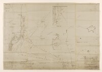
The map was produced by the Bahrain Petroleum Company (BAPCO), and was originally produced on 9 September 1938. Includes list of revisions to 27 February 1939.
The map shows existing marked barge channel, and routes (listed A, B, C, D), from Zellaq, Bahrein [Bahrain] to [Saudi] Arabia, and entrance channel. Also shows Khobar Terminal, Saudi Arabia, and Bird Island. Includes notes on soundings Measurements of the depth of a body of water. and bottom.
Inset A small map or other image enclosed within the margin of a larger map, map sheet, or larger image; or papers placed inside a book or archival volume. : marginal map (scale 1:25,000), showing South Twin Dune, Saudi Arabia.
A letter from the Political Agent A mid-ranking political representative (equivalent to a Consul) from the diplomatic corps of the Government of India or one of its subordinate provincial governments, in charge of a Political Agency. , Bahrain (Hugh Weightman) to the Political Resident A senior ranking political representative (equivalent to a Consul General) from the diplomatic corps of the Government of India or one of its subordinate provincial governments, in charge of a Political Residency. in the Persian Gulf The historical term used to describe the body of water between the Arabian Peninsula and Iran. (Sir Trenchard Craven William Fowle), on folios 70-74, relates to the map.
- Extent and format
- 1 map
- Area map covers
- Map loading...
- Scale
- 1:50,000
- Scale designator
- Horizontal
- Orientation
- North
- Degree coordinates
- Top-left: 26° 21' 35.57" N, 50° 6' 21.23" E
Top-right: 26° 21' 35.57" N, 50° 37' 25.06" E
Bottom-left: 25° 59' 20.07" N, 50° 6' 21.23" E
Bottom-right: 25° 59' 20.07" N, 50° 37' 25.06" E - It is part of
- 259 imagesRef: IOR/L/PS/12/3907
- Physical characteristics
Materials: blueprint on paper.
Dimensions: 660 x 980mm, on sheet 700 x 1010mm.
- Written in
- English in Latin script
- Type
- Map
Archive information for this record
- Original held at
- British Library: India Office The department of the British Government to which the Government of India reported between 1858 and 1947. The successor to the Court of Directors. Records and Private Papers Documents collected in a private capacity.
- Access conditions
Unrestricted
- Archive reference
- IOR/L/PS/12/3907, f 74
- Former external reference(s)
- BR - 513
- Date(s)
- 27 Feb 1939 (CE, Gregorian)
Access & Reference
History of this record
Use and share this record
- Share this record
- Cite this record in your research
'HYDROGRAPHY - SELF PROPELLED BARGE CHANNELS. ZELLAQ, BAHREIN TO ARABIA.', British Library: India Office Records and Private Papers, IOR/L/PS/12/3907, f 74, in Qatar Digital Library <https://www.qdl.qa/archive/81055/vdc_100088049971.0x000002> [accessed 23 April 2024]
- Link to this record
https://www.qdl.qa/en/archive/81055/vdc_100088049971.0x000002
- IIIF details
This record has a IIIF manifest available as follows. If you have a compatible viewer you can drag the icon to load it.https://www.qdl.qa/en/iiif/81055/vdc_100000000648.0x0001dd/manifestOpen in Universal viewerOpen in Mirador viewerMore options for embedding images
Copyright: How to use this content
- Reference
- IOR/L/PS/12/3907, f 74
- Title
- 'HYDROGRAPHY - SELF PROPELLED BARGE CHANNELS. ZELLAQ, BAHREIN TO ARABIA.'
- Pages
- 74r:74v
- Author
- Bahrain Petroleum Company (BAPCO)
- Usage terms
- The copyright status is unknown. Please contact copyright@bl.uk with any information you have regarding this item.