![‘FIG. 12. Northern Khurasan and the Hari Rud.’ [‎41v] (2/2)](https://iiif.qdl.qa/iiif/images/81055/vdc_100000000884.0x0001e2/IOR_L_PS_20_C259_0096.jp2/full/!1200,1200/0/default.jpg "‘FIG. 12. Northern Khurasan and the Hari Rud.’ [‎41v] (2/2)")
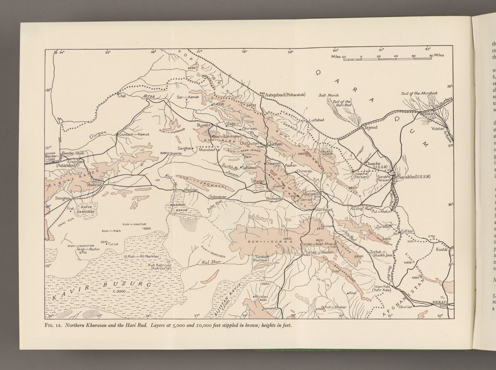
‘FIG. 12. Northern Khurasan and the Hari Rud.’ [41v] (2/2)
The record is made up of 1 map sheet. It was created in Sep 1945. It was written in English. The original is part of the British Library: India Office The department of the British Government to which the Government of India reported between 1858 and 1947. The successor to the Court of Directors. Records and Private Papers Documents collected in a private capacity. .
About this item
- Content
A map of northern Khurasan [Khorasan] in north-east Persia [Iran], with parts of Afghanistan and the Turkmen Soviet Socialist Republic [Turkmenistan] along the Hari Rud river.
Areas of elevation over 5000 feet above sea level are coloured in brown; areas over 10000 feet above sea level are coloured in dark brown. The elevation of various towns and mountains is also indicated in feet.
Black lines indicate hydrology, roads, and railways. The map also indicates major cities, deserts, and mountain ranges. The Soviet and Afghan borders are indicated with crossed lines.
- Extent and format
- 1 map sheet
- Area map covers
- Map loading...
- Scale
- Scale: 1:2798859
- Scale designator
- Horizontal
- Orientation
- North
- Degree coordinates
- Top-left: 38° 0' 0" N, 54° 0' 0" E
Top-right: 38° 0' 0" N, 62° 0' 0" E
Bottom-left: 35° 0' 0" N, 54° 0' 0" E
Bottom-right: 35° 0' 0" N, 62° 0' 0" E - Physical characteristics
Materials: Printed in colour on paper
Dimensions: 268 x 178mm, on sheet 295 x 217mm
- Written in
- English in Latin script View the complete information for this record
Use and share this item
- Share this item
‘FIG. 12. Northern Khurasan and the Hari Rud.’ [41v] (2/2), British Library: India Office Records and Private Papers, IOR/L/PS/20/C259, f 41, in Qatar Digital Library <https://www.qdl.qa/archive/81055/vdc_100180836496.0x000075> [accessed 17 May 2024]
https://www.qdl.qa/en/archive/81055/vdc_100180836496.0x000075
Copy and paste the code below into your web page where you would like to embed the image.
<meta charset="utf-8"><a href="https://www.qdl.qa/en/archive/81055/vdc_100180836496.0x000075">‘FIG. 12. Northern Khurasan and the Hari Rud.’ [‎41v] (2/2)</a> <a href="https://www.qdl.qa/en/archive/81055/vdc_100180836496.0x000075"> <img src="https://iiif.qdl.qa/iiif/images/81055/vdc_100000000884.0x0001e2/IOR_L_PS_20_C259_0096.jp2/full/!280,240/0/default.jpg" alt="" /> </a>
This record has a IIIF manifest available as follows. If you have a compatible viewer you can drag the icon to load it.https://www.qdl.qa/en/iiif/81055/vdc_100000000884.0x0001e2/manifestOpen in Universal viewerOpen in Mirador viewerMore options for embedding images
Copyright: How to use this content
- Reference
- IOR/L/PS/20/C259, f 41
- Title
- ‘FIG. 12. Northern Khurasan and the Hari Rud.’
- Pages
- 41r:41v
- Author
- East India Company, the Board of Control, the India Office, or other British Government Department
- Usage terms
- Public Domain