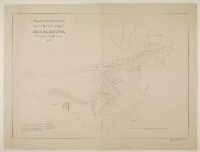
‘Trigonometrical plan of the backwater at Ras Al Khyma. By Lieut. J.M. Guy, drawn by M. Houghton’
IOR/X/3685
2 items in this record
Search within this record
The record is made up of 1 map sheet. It was created in 1822. It was written in English. The original is part of the British Library: Map Collections.
About this record
- Content
Distinctive Features:
Depths shown by soundings Measurements of the depth of a body of water. .
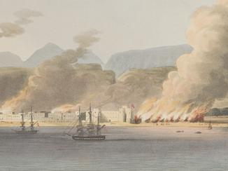
Detailed chart of Ras Al Khyma with some place names given both in English and Arabic.
Includes an explanation note in the bottom left.
- Extent and format
- 1 map sheet
- Area map covers
- Map loading...
- Scale
- not given
- Scale designator
- Horizontal
- Orientation
- North
- Degree coordinates
- Top-left: 25° 50' 8.23" N, 55° 55' 25.95" E
Top-right: 25° 50' 8.23" N, 56° 1' 20.25" E
Bottom-left: 25° 45' 35.49" N, 55° 55' 25.95" E
Bottom-right: 25° 45' 35.49" N, 56° 1' 20.25" E - Physical characteristics
Materials:
Pen and ink on paper
Dimensions:
570 x 800 mm
- Written in
- English in Latin script
- Type
- Map
Archive information for this record
- Original held at
- British Library: Map Collections
- Access conditions
Unrestricted
- Archive reference
- IOR/X/3685
- Former external reference(s)
- U.VI.39
- Date(s)
- 1822 (CE, Gregorian)
Access & Reference
History of this record
Related material
Related search terms
- Places
- Ra's al-Khaymah
- People & organisations
- John M. GuyMichael Houghton
Use and share this record
- Share this record
- Cite this record in your research
‘Trigonometrical plan of the backwater at Ras Al Khyma. By Lieut. J.M. Guy, drawn by M. Houghton’, British Library: Map Collections, IOR/X/3685, in Qatar Digital Library <https://www.qdl.qa/node/323> [accessed 3 July 2026]
- Link to this record
https://www.qdl.qa/en/archive/81055/vdc_100000010831.0x000001
- IIIF details
This record has a IIIF manifest available as follows. If you have a compatible viewer you can drag the icon to load it.https://www.qdl.qa/en/iiif/81055/vdc_100000010831.0x000001/manifestOpen in Universal viewerOpen in Mirador viewerMore options for embedding images
Copyright: How to use this content
- Reference
- IOR/X/3685
- Title
- ‘Trigonometrical plan of the backwater at Ras Al Khyma. By Lieut. J.M. Guy, drawn by M. Houghton’
- Pages
- 1r:1v
- Author
- Please see item description
- Usage terms
- Public Domain