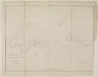
‘TRIGONOMERTICAL PLAN of the HARBOUR OF GRANE OR KOWEIT in the GULF OF PERSIA. By Lieutts. J.M. Guy and G.B. Brucks, H.E.I.C. Marine’
IOR/R/15/1/732, p 51A

2 items in this record
Search within this record
The record is made up of 1 map sheet. It was created in 1855. It was written in English. The original is part of the British Library: India Office The department of the British Government to which the Government of India reported between 1858 and 1947. The successor to the Court of Directors. Records and Private Papers Documents collected in a private capacity. .
About this record
- Content
Imprint:
Lithographed A lithograph is an image reproduced from a printing plate whose image areas attract ink and non-image areas repel it. in the Chief Engineer’s Office by G. Luxumonjee and K, E. Bombay, 6th Sept.r 1855.
Distinctive Features:
Produced to accompany a report on the Harbour of Grane (or Koweit), and the Island of Pheleechi, prepared by Lieutenant J. Felix Jones, Indian Navy.
Depth shown by detailed soundings Measurements of the depth of a body of water. in fathoms. Mud flats, areas partly dry at low water indicated with anchorage for shipping and boats marked. Includes an explanatory note at the bottom right-hand corner.
- Extent and format
- 1 map sheet
- Area map covers
- Map loading...
- Scale
- Scale approximately 1:130,000
- Scale designator
- Horizontal
- Orientation
- North
- Degree coordinates
- Top-left: 29° 37' 4.08" N, 47° 26' 34.44" E
Top-right: 29° 37' 4.08" N, 48° 35' 3.48" E
Bottom-left: 28° 59' 38.4" N, 47° 26' 34.44" E
Bottom-right: 28° 59' 38.4" N, 48° 35' 3.48" E - It is part of
- 733 imagesRef: IOR/R/15/1/732
- Physical characteristics
Dimensions:
382 x 513 mm, on sheet 444 x 558 mm
- Written in
- English in Latin script
- Type
- Map
Archive information for this record
- Original held at
- British Library: India Office The department of the British Government to which the Government of India reported between 1858 and 1947. The successor to the Court of Directors. Records and Private Papers Documents collected in a private capacity.
- Access conditions
Unrestricted
- Archive reference
- IOR/R/15/1/732, p 51A
- Date(s)
- 1855 (CE, Gregorian)
Access & Reference
History of this record
Related material
Related search terms
- Places
- Kuwait BayMuscatBahrainKuwaitTrucial StatesQatarSitrahSitraBūshehrAbū-ShahrHormuz Isle
- People & organisations
- James OrtonFrancis Warden
Use and share this record
- Share this record
- Cite this record in your research
‘TRIGONOMERTICAL PLAN of the HARBOUR OF GRANE OR KOWEIT in the GULF OF PERSIA. By Lieutts. J.M. Guy and G.B. Brucks, H.E.I.C. Marine’, British Library: India Office Records and Private Papers, IOR/R/15/1/732, p 51A, in Qatar Digital Library <https://www.qdl.qa/archive/81055/vdc_100022950124.0x000002> [accessed 19 April 2024]
- Link to this record
https://www.qdl.qa/en/archive/81055/vdc_100022950124.0x000002
- IIIF details
This record has a IIIF manifest available as follows. If you have a compatible viewer you can drag the icon to load it.https://www.qdl.qa/en/iiif/81055/vdc_100000000193.0x0002c3/manifestOpen in Universal viewerOpen in Mirador viewerMore options for embedding images
Copyright: How to use this content
- Reference
- IOR/R/15/1/732, p 51A
- Title
- ‘TRIGONOMERTICAL PLAN of the HARBOUR OF GRANE OR KOWEIT in the GULF OF PERSIA. By Lieutts. J.M. Guy and G.B. Brucks, H.E.I.C. Marine’
- Pages
- 51a:51b
- Author
- East India Company, the Board of Control, the India Office, or other British Government Department
- Usage terms
- Open Government Licence