!['Military Report and Route Book. The Arabian States of the Persian Gulf. 1939' [‎67r] (133/328)](https://iiif.qdl.qa/iiif/images/81055/vdc_100000000884.0x0001da/IOR_L_PS_20_C252_0134.jp2/full/!1200,1200/0/default.jpg "'Military Report and Route Book. The Arabian States of the Persian Gulf. 1939' [‎67r] (133/328)")
'Military Report and Route Book. The Arabian States of the Persian Gulf. 1939' [67r] (133/328)
The record is made up of 1 volume (157 folios and 7 maps in pocket). It was created in 1940. It was written in English. The original is part of the British Library: India Office The department of the British Government to which the Government of India reported between 1858 and 1947. The successor to the Court of Directors. Records and Private Papers Documents collected in a private capacity. .
Transcription
This transcription is created automatically. It may contain errors.
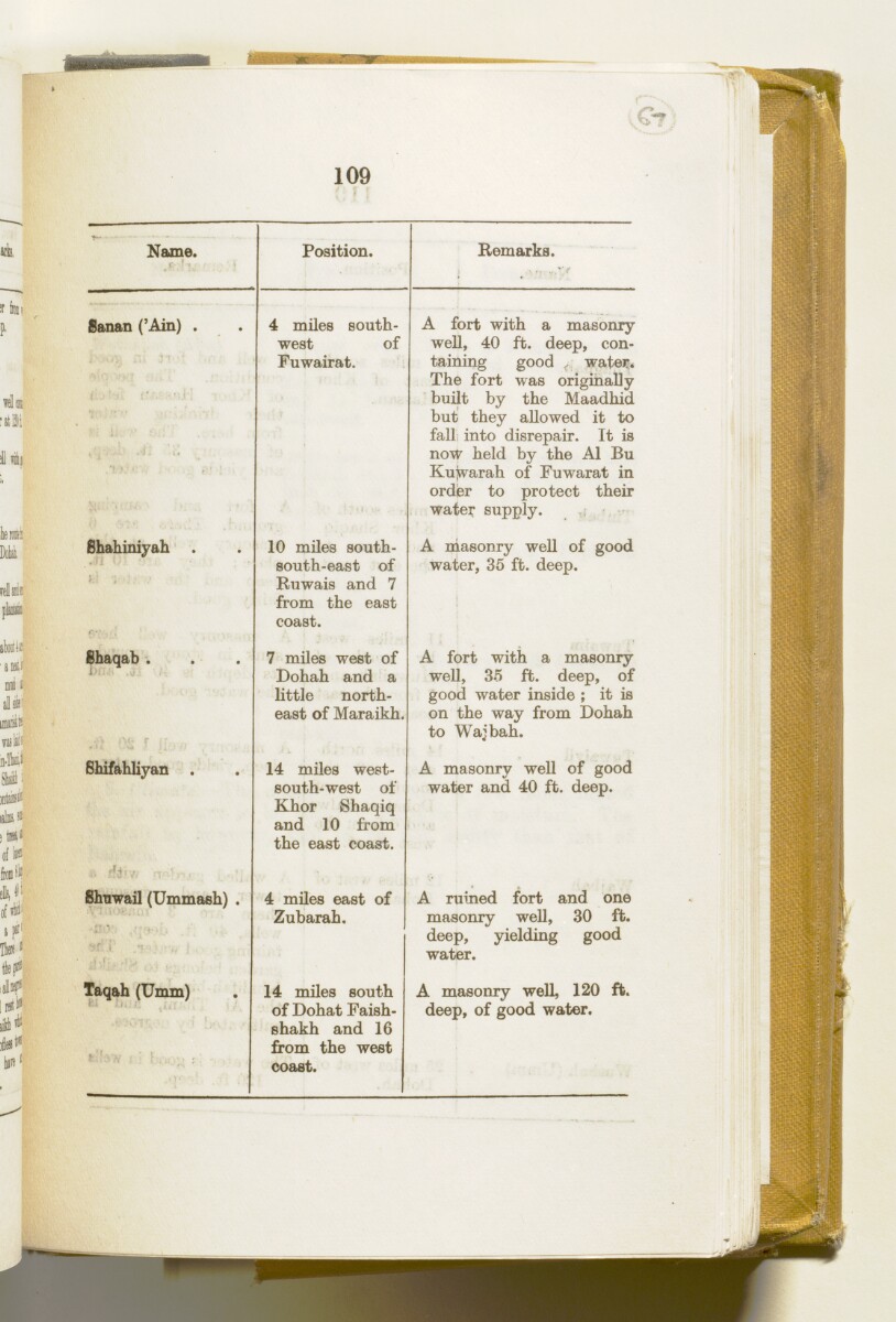
109
C-
Name.
r 1 •
Position.
Remarks.
Sanan ('Ain) .
'J " ■
iq-rA A.
4 miles south
west of
Fuwairat.
A fort with a masonry
well, 40 ft. deep, con
taining good < water.
The fort was originally
built by the Maadhid
but they allowed it to
fall; into disrepair. It is
now held by the A1 Bu
Kuwarah of Fuwarat in
order to protect their
water supply.
Shahiniyah .
y .
10 miles south-
south-east of
Ruwais and 7
from the east
coast.
A masonry well of good
water, 35 ft. deep.
Shaqab .
■
7 miles west of
Dohah and a
little north
east of Maraikh,
A fort with a masonry
well, 35 ft. deep, of
good water inside ; it is
on the way from Dohah
to Wajbah.
Shifahliyan .
14 miles west-
south-west of
Khor Shaqiq
and 10 from
the east coast.
A masonry well of good
water and 40 ft. deep.
Shnwail (Ummash) .
fdT ."} ■; „ i
4 miles east of
Zubarah
18th-century town located 105 km from Doha.
.
A ruined fort and one
masonry well, 30 ft.
deep, yielding good
water.
Taqah (Umm)
• 1 ; :
14 miles south
of Dohat Faish-
shakh and 16
from the west
coast.
A masonry well, 120 ft.
deep, of good water.
About this item
- Content
This volume contains geographical information and maps about the Arabian States of the Persian Gulf The historical term used to describe the body of water between the Arabian Peninsula and Iran. . It was produced by the General Staff, India, and printed by the Manager, Government of India Press, Simla, 1940.
The volume is divided into two sections: 'Military Report' including general descriptions of Kuwait, Bahrein, Hasa, Qatar, the Trucial Coast A name used by Britain from the nineteenth century to 1971 to refer to the present-day United Arab Emirates. , Muscat and Oman (folios 6-127) and 'Routes' (folios 128-164) including maps of:
- The Arabian States of the Persian Gulf The historical term used to describe the body of water between the Arabian Peninsula and Iran. , Muscat and Oman, and Routes in the area (f 158);
- Kuwait Area (f 159);
- Bahrein, Hasa and Qatar (f 160);
- Trucial Oman A name used by Britain from the nineteenth century to 1971 to refer to the present-day United Arab Emirates. (f 161);
- Muscat and Oman (f 162);
and sketches of:
- Bahrein Oil Company's area and important places (f 163);
- Sharjah and Dibai [Dubai] (f 158).
- Extent and format
- 1 volume (157 folios and 7 maps in pocket)
- Physical characteristics
There is a foliation sequence, which is circled in pencil, in the top right corner of the recto The front of a sheet of paper or leaf, often abbreviated to 'r'. of each folio. It begins on the front cover, on number 1, and ends on the last of several maps which are stored in a pocket at the back of the volume, on number 164.
- Written in
- English in Latin script View the complete information for this record
Use and share this item
- Share this item
'Military Report and Route Book. The Arabian States of the Persian Gulf. 1939' [67r] (133/328), British Library: India Office Records and Private Papers, IOR/L/PS/20/C252, in Qatar Digital Library <https://www.qdl.qa/archive/81055/vdc_100023722174.0x000087> [accessed 10 May 2024]
https://www.qdl.qa/en/archive/81055/vdc_100023722174.0x000087
Copy and paste the code below into your web page where you would like to embed the image.
<meta charset="utf-8"><a href="https://www.qdl.qa/en/archive/81055/vdc_100023722174.0x000087">'Military Report and Route Book. The Arabian States of the Persian Gulf. 1939' [‎67r] (133/328)</a> <a href="https://www.qdl.qa/en/archive/81055/vdc_100023722174.0x000087"> <img src="https://iiif.qdl.qa/iiif/images/81055/vdc_100000000884.0x0001da/IOR_L_PS_20_C252_0134.jp2/full/!280,240/0/default.jpg" alt="" /> </a>
This record has a IIIF manifest available as follows. If you have a compatible viewer you can drag the icon to load it.https://www.qdl.qa/en/iiif/81055/vdc_100000000884.0x0001da/manifestOpen in Universal viewerOpen in Mirador viewerMore options for embedding images
Copyright: How to use this content
- Reference
- IOR/L/PS/20/C252
- Title
- 'Military Report and Route Book. The Arabian States of the Persian Gulf. 1939'
- Pages
- front, front-i, 2r:156v, 158r:164v, back-i, back
- Author
- East India Company, the Board of Control, the India Office, or other British Government Department
- Usage terms
- Open Government Licence