![‘Plan 6. Panorama from Fort Snipe to illustrate first phase of the operations against Amara’ [‎52a] (1/1)](https://iiif.qdl.qa/iiif/images/81055/vdc_100000000239.0x00018d/IOR_L_MIL_17_15_73_0066.jp2/full/!1200,1200/0/default.jpg "‘Plan 6. Panorama from Fort Snipe to illustrate first phase of the operations against Amara’ [‎52a] (1/1)")
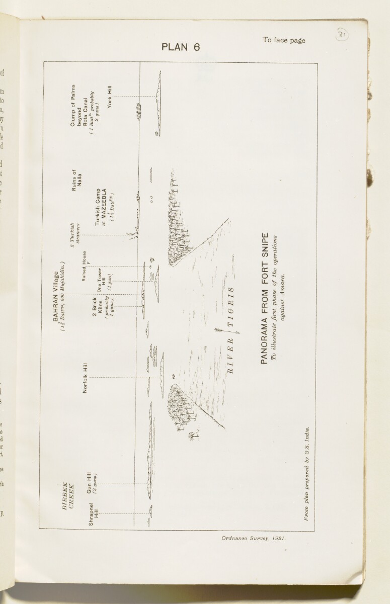
‘Plan 6. Panorama from Fort Snipe to illustrate first phase of the operations against Amara’ [52a] (1/1)
The record is made up of 1 map. It was created in 1921. It was written in English. The original is part of the British Library: India Office The department of the British Government to which the Government of India reported between 1858 and 1947. The successor to the Court of Directors. Records and Private Papers Documents collected in a private capacity. .
About this item
- Content
Imprint:
Ordnance Survey, 1921.
Distinctive Features:
View from Fort Snipe at the Tigris River bend near Qurna drawn from plan prepared by G.S. India; landmarks labelled for reference with position and number of Turkish forces reported.
- Extent and format
- 1 map
- Area map covers
- Map loading...
- Scale
- Scale not given
- Scale designator
- Horizontal
- Orientation
- North
- Degree coordinates
- Top-left: 31° 9' 34.98" N, 47° 25' 25.89" E
Top-right: 31° 9' 34.98" N, 47° 28' 52.91" E
Bottom-left: 31° 7' 27.75" N, 47° 25' 25.89" E
Bottom-right: 31° 7' 27.75" N, 47° 28' 52.91" E - Physical characteristics
Dimensions: 120 x 204 mm, on sheet 152 x 245 mm
- Written in
- English in Latin script View the complete information for this record
Use and share this item
- Share this item
‘Plan 6. Panorama from Fort Snipe to illustrate first phase of the operations against Amara’ [52a] (1/1), British Library: India Office Records and Private Papers, IOR/L/MIL/17/15/73, p 52a, in Qatar Digital Library <https://www.qdl.qa/archive/81055/vdc_100023813250.0x000043> [accessed 30 April 2024]
https://www.qdl.qa/en/archive/81055/vdc_100023813250.0x000043
Copy and paste the code below into your web page where you would like to embed the image.
<meta charset="utf-8"><a href="https://www.qdl.qa/en/archive/81055/vdc_100023813250.0x000043">‘Plan 6. Panorama from Fort Snipe to illustrate first phase of the operations against Amara’ [‎52a] (1/1)</a> <a href="https://www.qdl.qa/en/archive/81055/vdc_100023813250.0x000043"> <img src="https://iiif.qdl.qa/iiif/images/81055/vdc_100000000239.0x00018d/IOR_L_MIL_17_15_73_0066.jp2/full/!280,240/0/default.jpg" alt="" /> </a>
This record has a IIIF manifest available as follows. If you have a compatible viewer you can drag the icon to load it.https://www.qdl.qa/en/iiif/81055/vdc_100000000239.0x00018d/manifestOpen in Universal viewerOpen in Mirador viewerMore options for embedding images
Copyright: How to use this content
- Reference
- IOR/L/MIL/17/15/73, p 52a
- Title
- ‘Plan 6. Panorama from Fort Snipe to illustrate first phase of the operations against Amara’
- Pages
- 52a
- Author
- Ordnance Survey
- Usage terms
- Public Domain