!['ROUTES IN PERSIA. SECTION III' [‎29r] (62/739)](https://iiif.qdl.qa/iiif/images/81055/vdc_100000001491.0x000114/Mss Eur F111_371_0062.jp2/full/!1200,1200/0/default.jpg "'ROUTES IN PERSIA. SECTION III' [‎29r] (62/739)")
'ROUTES IN PERSIA. SECTION III' [29r] (62/739)
The record is made up of 1 volume (367 folios). It was created in 1898. It was written in English. The original is part of the British Library: India Office The department of the British Government to which the Government of India reported between 1858 and 1947. The successor to the Court of Directors. Records and Private Papers Documents collected in a private capacity. .
Transcription
This transcription is created automatically. It may contain errors.
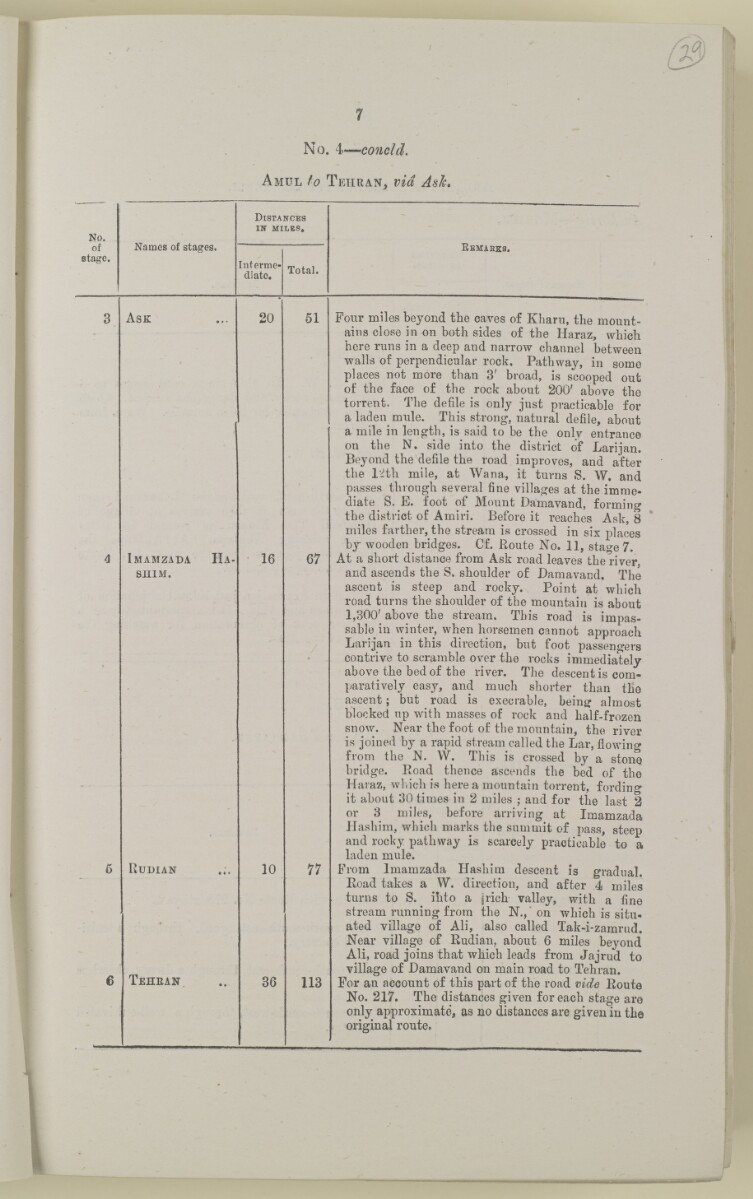
No. 4— conoid.
A mul to T ehran, via Ask.
No.
of
stage.
Names of stages.
Distances
in miles,
Interme
diate.
Total.
RBMAHKa.
A sk
20
Imamzada Ha
shim.
Rudian
T ehran
16
10
51
67
77
36
113
Four miles beyond the caves of Kharu, the mount
ains close in on both sides of the Haraz, which
here runs in a deep and narrow channel between
walls of perpendicular rock. Pathway, in some
places not more than 3' broad, is scooped out
of the face of the rock about 200' above the
torrent. The defile is only just practicable for
a laden mule. This strong, natural defile, about
a mile in length, is said to be the only entrance
on the N. side into the district of Larijan.
Beyond the defile the road improves, and after
the I'ith mile, at Wana, it turns S. W. and
passes through several fine villages at the imme
diate S. E. foot of Mount Damavand, forming
the district of Amiri. Before it reaches Ask, 8
miles farther, the stream is crossed in six places
by wooden bridges. Cf. Route No. 11, stage 7.
At a short distance from Ask road leaves the river,
and ascends the S. shoulder of Bamavand. The
ascent is steep and rocky. Point at which
road turns the shoulder of the mountain is about
1,300' above the stream. This road is impas
sable in winter, when horsemen cannot approach
Larijan in this direction, but foot passengers
contrive to scramble over the rocks immediately
above the bed of the river. The descent is com
paratively easy, and much shorter than the
ascent; but road is execrable, being: almost
blocked up with masses of rock and half-frozen
snow. Near the foot of the mountain, the river
is joined by a rapid stream called the Lar, flowing
from the N. W. This is crossed by a stone
bridge. Road thence ascends the bed of the
Haraz, which is here a mountain torrent, fording
it about 30 times in 2 miles ; and for the last 2
or 3 miles, before arriving at Imamzada
Hashim, which marks the summit of pass, steep
and rocky pathway is scarcely practicable to a
laden mule.
From Imamzada Hashim descent is gradual.
Road takes a W. direction, and after 4 miles
turns to S. into a (rich valley, with a fine
stream running from the N., on which is situ
ated village of Ali, also called Tak-i-zamrud.
Near village of Rudian, about 6 miles beyond
Ali, road joins that which leads from Jajrud to
village of Bamavand on main road to Tehran.
For an account of this part of the road vide Route
No. 217. The distances given for each stage are
only approximate, as no distances are given in the
original route.
About this item
- Content
The volume is a Government of India official publication entitled Routes in Persia. Section III. Compiled in the Intelligence Branch of the Quarter Master General's Department in India (Simla: printed at the Government Central Printing Office, 1898).
The volume contains details of all land routes (numbered 1-247) in Persia starting from Russian territory and extending south as far as a line drawn from Karmanshah [Kermānshāh] south-eastwards through Burujird [Borūjerd], Isfahan [Eşfahān] and Yazd to Karman [Kermān], and thence north-east to Khabis [Khabīş] and Neh to Lash Juwain [Lāsh-e Juwayn].
The information given for each route comprises:
- number of route;
- place names forming starting point and destination of route;
- authority and date;
- number of stage;
- names of stages;
- distance in miles (intermediate and total);
- remarks (including precise details of the route, general geographical information, and information on smaller settlements, local peoples, agriculture, condition of roads, access to water, supplies of wood, and other routes).
An appendix within the volume (folios 356-359) and two separately-stored sets of loose sheets (containing routes numbers 77 (a) and 140-A, folios 363-369) give information too late for incorporation in the body of the work.
The volume also contains pockets attached to the front and back inside covers for maps. These consist of an index map showing the limits of each of the three sections of Routes in Persia (folio 2) and an index map to the routes in Section III (folio 361). There is also a fold-out map of the route from Seistan [Sīstān] to Mashad on folio 232.
An ink stamp on the front cover records the confidential nature of the publication and that it was being transmitted for the information of His Excellency the Viceroy (Victor Alexander Bruce, 9th Earl of Elgin and 16th Earl of Kincardine) only.
- Extent and format
- 1 volume (367 folios)
- Arrangement
The volume contains an alphabetical cross index (folios 6-17), and an alphabetical index to names of places (folios 18-25).
- Physical characteristics
Foliation: the foliation sequence commences at the front cover and terminates on the last page of the loose supplementary sheets (found in the small grey folder within the main folder); these numbers are written in pencil, are circled, and are located in the top right corner of the recto The front of a sheet of paper or leaf, often abbreviated to 'r'. side of each folio.
Pagination: the volume also contains a printed pagination sequence.
- Written in
- English in Latin script View the complete information for this record
Use and share this item
- Share this item
'ROUTES IN PERSIA. SECTION III' [29r] (62/739), British Library: India Office Records and Private Papers, Mss Eur F111/371, in Qatar Digital Library <https://www.qdl.qa/archive/81055/vdc_100024054420.0x00003f> [accessed 24 April 2024]
https://www.qdl.qa/en/archive/81055/vdc_100024054420.0x00003f
Copy and paste the code below into your web page where you would like to embed the image.
<meta charset="utf-8"><a href="https://www.qdl.qa/en/archive/81055/vdc_100024054420.0x00003f">'ROUTES IN PERSIA. SECTION III' [‎29r] (62/739)</a> <a href="https://www.qdl.qa/en/archive/81055/vdc_100024054420.0x00003f"> <img src="https://iiif.qdl.qa/iiif/images/81055/vdc_100000001491.0x000114/Mss Eur F111_371_0062.jp2/full/!280,240/0/default.jpg" alt="" /> </a>
This record has a IIIF manifest available as follows. If you have a compatible viewer you can drag the icon to load it.https://www.qdl.qa/en/iiif/81055/vdc_100000001491.0x000114/manifestOpen in Universal viewerOpen in Mirador viewerMore options for embedding images
Copyright: How to use this content
- Reference
- Mss Eur F111/371
- Title
- 'ROUTES IN PERSIA. SECTION III'
- Pages
- front, back, spine, edge, head, tail, front-i, 2r:58r, 59r:232r, 232r:233r, 234r:361v, back-i, 363r:363v, 365r:369v
- Author
- East India Company, the Board of Control, the India Office, or other British Government Department
- Usage terms
- Open Government Licence