!['ROUTES IN PERSIA. SECTION III' [‎61r] (126/739)](https://iiif.qdl.qa/iiif/images/81055/vdc_100000001491.0x000114/Mss Eur F111_371_0125.jp2/full/!1200,1200/0/default.jpg "'ROUTES IN PERSIA. SECTION III' [‎61r] (126/739)")
'ROUTES IN PERSIA. SECTION III' [61r] (126/739)
The record is made up of 1 volume (367 folios). It was created in 1898. It was written in English. The original is part of the British Library: India Office The department of the British Government to which the Government of India reported between 1858 and 1947. The successor to the Court of Directors. Records and Private Papers Documents collected in a private capacity. .
Transcription
This transcription is created automatically. It may contain errors.
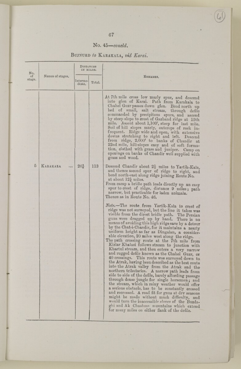
67
No, 45— conoid.
B ujnurd to K arakaxa, via Karai.
No.
of
stage.
Names of stages.
D istances
in miles.
Bemaees.
Interme
diate.
Total.
5
Karakaia.
26i
113
At 7tli mile cross low marly spur, and descend
into glen of Karai. Path from Karakala to
Chahel Guzr passes down glen. Bend north up
bed of small, salt stream, through defile
commanded by precipitous spurs, and ascend
by steep slope to crest of Gazband ridge at 15th
mile. Ascent about 1,100', steep for last mile.
Soil of hill slopes marly, outcrops of rock in
frequent. Ridge wide and open, with extensive
downs stretching to right and left. Descend
from ridge, ^ 2,000' to banks of Chandir at
22nd mile, hill-slopes easy and of soft forma
tion, clothed with grass and juniper. Camp on
openings on banks of Chandir well supplied with
grass and wood.
Descend Chandir about 2| miles to Yartik-Kala,
and thence ascend spur of ridge to right, and
bend north-east along ridge joining Route No.
at about ]2|- miles.
From camp a bridle path leads directly up an easy
spur to crest of ridge, distance 9 miles j path
narrow, but practicable for laden animals.
Thence as in Route No. 46.
Note. —The route from Yartik-Kala to crest of
ridge was not surveyed, but the line it takes was
visible from the direct bridle path. The Persian
guns were dragged up by hand. There is no
means of avoiding this high ridge save by a detour
by the Chat-i-Ghandiivfor it maintains a nearly
uniform height as far as Dingalan, a consider
able elevation, 20 miles west along the ridge.
The path crossing route at the 7th mile from
Kizlar
Khalasi
Used by the British officials to refer to a non-European labourer, especially one employed on a ship.
follows stream to junction with
Khartul stream, and then enters a' very narrow
and rugged defile known as the Chahel Guzr, or
40 crossings. This route was surveyed down to
the Atrak, having been described as the best route
into the Atrak valley from the Atrak and the-
northern tributaries. A narrow path leads from
side to side of the defile, barely affording passage
through dense jungle for single horsemen; and
the stream, which in rainy weather would offer
a serious obstacle, has to be constantly crossed
and recrossed. A road fit for guns at drv seasons
might be mnde without much difficulty, and
would turn the inaccessible slones of the Buzda-
glii and Ak Chashmn mountains which extend
for many miles on either flank of the defile.
About this item
- Content
The volume is a Government of India official publication entitled Routes in Persia. Section III. Compiled in the Intelligence Branch of the Quarter Master General's Department in India (Simla: printed at the Government Central Printing Office, 1898).
The volume contains details of all land routes (numbered 1-247) in Persia starting from Russian territory and extending south as far as a line drawn from Karmanshah [Kermānshāh] south-eastwards through Burujird [Borūjerd], Isfahan [Eşfahān] and Yazd to Karman [Kermān], and thence north-east to Khabis [Khabīş] and Neh to Lash Juwain [Lāsh-e Juwayn].
The information given for each route comprises:
- number of route;
- place names forming starting point and destination of route;
- authority and date;
- number of stage;
- names of stages;
- distance in miles (intermediate and total);
- remarks (including precise details of the route, general geographical information, and information on smaller settlements, local peoples, agriculture, condition of roads, access to water, supplies of wood, and other routes).
An appendix within the volume (folios 356-359) and two separately-stored sets of loose sheets (containing routes numbers 77 (a) and 140-A, folios 363-369) give information too late for incorporation in the body of the work.
The volume also contains pockets attached to the front and back inside covers for maps. These consist of an index map showing the limits of each of the three sections of Routes in Persia (folio 2) and an index map to the routes in Section III (folio 361). There is also a fold-out map of the route from Seistan [Sīstān] to Mashad on folio 232.
An ink stamp on the front cover records the confidential nature of the publication and that it was being transmitted for the information of His Excellency the Viceroy (Victor Alexander Bruce, 9th Earl of Elgin and 16th Earl of Kincardine) only.
- Extent and format
- 1 volume (367 folios)
- Arrangement
The volume contains an alphabetical cross index (folios 6-17), and an alphabetical index to names of places (folios 18-25).
- Physical characteristics
Foliation: the foliation sequence commences at the front cover and terminates on the last page of the loose supplementary sheets (found in the small grey folder within the main folder); these numbers are written in pencil, are circled, and are located in the top right corner of the recto The front of a sheet of paper or leaf, often abbreviated to 'r'. side of each folio.
Pagination: the volume also contains a printed pagination sequence.
- Written in
- English in Latin script View the complete information for this record
Use and share this item
- Share this item
'ROUTES IN PERSIA. SECTION III' [61r] (126/739), British Library: India Office Records and Private Papers, Mss Eur F111/371, in Qatar Digital Library <https://www.qdl.qa/archive/81055/vdc_100024054420.0x00007e> [accessed 18 April 2024]
https://www.qdl.qa/en/archive/81055/vdc_100024054420.0x00007e
Copy and paste the code below into your web page where you would like to embed the image.
<meta charset="utf-8"><a href="https://www.qdl.qa/en/archive/81055/vdc_100024054420.0x00007e">'ROUTES IN PERSIA. SECTION III' [‎61r] (126/739)</a> <a href="https://www.qdl.qa/en/archive/81055/vdc_100024054420.0x00007e"> <img src="https://iiif.qdl.qa/iiif/images/81055/vdc_100000001491.0x000114/Mss Eur F111_371_0125.jp2/full/!280,240/0/default.jpg" alt="" /> </a>
This record has a IIIF manifest available as follows. If you have a compatible viewer you can drag the icon to load it.https://www.qdl.qa/en/iiif/81055/vdc_100000001491.0x000114/manifestOpen in Universal viewerOpen in Mirador viewerMore options for embedding images
Copyright: How to use this content
- Reference
- Mss Eur F111/371
- Title
- 'ROUTES IN PERSIA. SECTION III'
- Pages
- front, back, spine, edge, head, tail, front-i, 2r:58r, 59r:232r, 232r:233r, 234r:361v, back-i, 363r:363v, 365r:369v
- Author
- East India Company, the Board of Control, the India Office, or other British Government Department
- Usage terms
- Open Government Licence