!['ROUTES IN PERSIA. SECTION III' [‎177v] (359/739)](https://iiif.qdl.qa/iiif/images/81055/vdc_100000001491.0x000114/Mss Eur F111_371_0357.jp2/full/!1200,1200/0/default.jpg "'ROUTES IN PERSIA. SECTION III' [‎177v] (359/739)")
'ROUTES IN PERSIA. SECTION III' [177v] (359/739)
The record is made up of 1 volume (367 folios). It was created in 1898. It was written in English. The original is part of the British Library: India Office The department of the British Government to which the Government of India reported between 1858 and 1947. The successor to the Court of Directors. Records and Private Papers Documents collected in a private capacity. .
Transcription
This transcription is created automatically. It may contain errors.
m
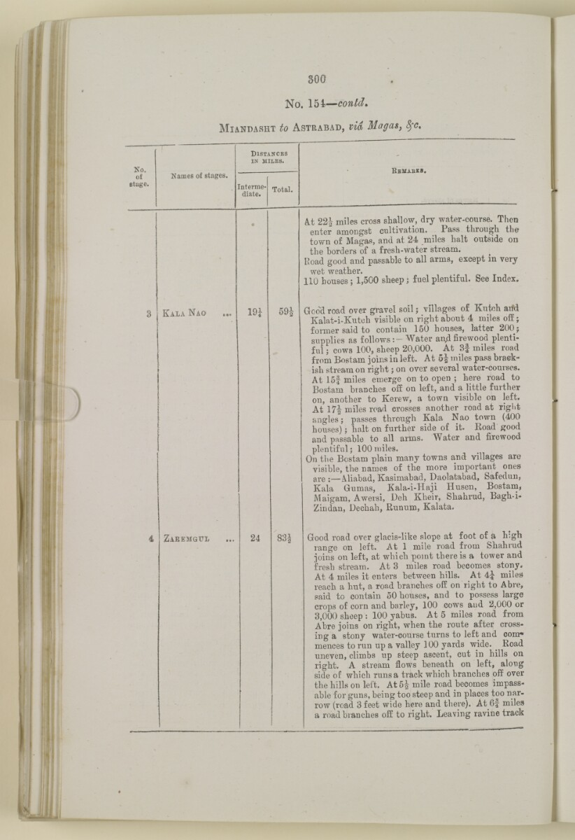
No. 154— could*
Miandasht to Astrabad, via
S, dfC,
No.
of
Btage.
Names of stages.
D istances
in miles.
Interme
diate.
Total.
kala nao
59:
Zaeemgul
24
B emabks.
Ai 22| miles cross shallow, dry water-course. Then
enter amongst cultivation. Pass through the
town of Magas, and at 24 miles halt outside on
the borders of a fresh-water stream.
Road good and passable to all arms, except in very
wet weather.
110 bouses; 1,500 sheep; fuel plentiful. See Index.
Good road over gravel soil; villages of Kutch arfd
Kalat-i-Kutch visible on right about 4 miles off;
former said to contain 150 houses, latter 200;
supplies as follows:- Water an/i firewood plenti
ful ; cows 100, sheep 20,000. At Sf miles road
from Bostam joins in left. At 5| miles pass brack
ish stream on right; on over several water-courses.
At 15f miles emerge on to open ; here road to
Bostam branches off on left, and a little further
on, another to Kerew, a town visible on left.
At 17| miles road crosses another road at right
angles; passes through Kala Nao town (400
houses); halt on further side of it. Koad good
and passable to all arms. Water and firewood
plentiful; 100 miles.
On the Bostam plain many towns and villages are
visible, the names of the more important ones
are ;—Aliabad, Kasimabad, Daolatabad, Safedun,
Kala Gumas, Kala-i-Haji Husen, Bostam,
Maigam, Awersi, Deh Kheir, Shahrud, Bagh-i-
Zindan, Dechah, Runum, Kalata.
Good road over glacis-like slope at foot of a h'-gh
range on left. At 1 mile road from Shahrud
joins on left, at which point there is a tower and
fresh stream. At 3 miles road becomes stony.
At 4 miles it enters between hills. At 4J miles
reach a hut, a road branches off on right to Abre,
said to contain 50 houses, and to possess large
crops of corn and barley, 100 cows and 2,000 or
3,000 sheep : 100 yabus. At 5 miles road from
Abre joins on right, when the route after cross
ing a stony water-course turns to left and com*
mences to run up a valley 100 yards wide. ^ Road
uneven, climbs up steep ascent, cut in hills on
right. A stream flows beneath on left, along
side of which runs a track which branches off over
the hills on left. At 5J mile road becomes impass
able for guns, being too steep and in places too nar
row (road 3 feet wide here and there). At 6f miles
a road branches off to right. Leaving ravine track
About this item
- Content
The volume is a Government of India official publication entitled Routes in Persia. Section III. Compiled in the Intelligence Branch of the Quarter Master General's Department in India (Simla: printed at the Government Central Printing Office, 1898).
The volume contains details of all land routes (numbered 1-247) in Persia starting from Russian territory and extending south as far as a line drawn from Karmanshah [Kermānshāh] south-eastwards through Burujird [Borūjerd], Isfahan [Eşfahān] and Yazd to Karman [Kermān], and thence north-east to Khabis [Khabīş] and Neh to Lash Juwain [Lāsh-e Juwayn].
The information given for each route comprises:
- number of route;
- place names forming starting point and destination of route;
- authority and date;
- number of stage;
- names of stages;
- distance in miles (intermediate and total);
- remarks (including precise details of the route, general geographical information, and information on smaller settlements, local peoples, agriculture, condition of roads, access to water, supplies of wood, and other routes).
An appendix within the volume (folios 356-359) and two separately-stored sets of loose sheets (containing routes numbers 77 (a) and 140-A, folios 363-369) give information too late for incorporation in the body of the work.
The volume also contains pockets attached to the front and back inside covers for maps. These consist of an index map showing the limits of each of the three sections of Routes in Persia (folio 2) and an index map to the routes in Section III (folio 361). There is also a fold-out map of the route from Seistan [Sīstān] to Mashad on folio 232.
An ink stamp on the front cover records the confidential nature of the publication and that it was being transmitted for the information of His Excellency the Viceroy (Victor Alexander Bruce, 9th Earl of Elgin and 16th Earl of Kincardine) only.
- Extent and format
- 1 volume (367 folios)
- Arrangement
The volume contains an alphabetical cross index (folios 6-17), and an alphabetical index to names of places (folios 18-25).
- Physical characteristics
Foliation: the foliation sequence commences at the front cover and terminates on the last page of the loose supplementary sheets (found in the small grey folder within the main folder); these numbers are written in pencil, are circled, and are located in the top right corner of the recto The front of a sheet of paper or leaf, often abbreviated to 'r'. side of each folio.
Pagination: the volume also contains a printed pagination sequence.
- Written in
- English in Latin script View the complete information for this record
Use and share this item
- Share this item
'ROUTES IN PERSIA. SECTION III' [177v] (359/739), British Library: India Office Records and Private Papers, Mss Eur F111/371, in Qatar Digital Library <https://www.qdl.qa/archive/81055/vdc_100024054421.0x00009e> [accessed 10 May 2024]
https://www.qdl.qa/en/archive/81055/vdc_100024054421.0x00009e
Copy and paste the code below into your web page where you would like to embed the image.
<meta charset="utf-8"><a href="https://www.qdl.qa/en/archive/81055/vdc_100024054421.0x00009e">'ROUTES IN PERSIA. SECTION III' [‎177v] (359/739)</a> <a href="https://www.qdl.qa/en/archive/81055/vdc_100024054421.0x00009e"> <img src="https://iiif.qdl.qa/iiif/images/81055/vdc_100000001491.0x000114/Mss Eur F111_371_0357.jp2/full/!280,240/0/default.jpg" alt="" /> </a>
This record has a IIIF manifest available as follows. If you have a compatible viewer you can drag the icon to load it.https://www.qdl.qa/en/iiif/81055/vdc_100000001491.0x000114/manifestOpen in Universal viewerOpen in Mirador viewerMore options for embedding images
Copyright: How to use this content
- Reference
- Mss Eur F111/371
- Title
- 'ROUTES IN PERSIA. SECTION III'
- Pages
- front, back, spine, edge, head, tail, front-i, 2r:58r, 59r:232r, 232r:233r, 234r:361v, back-i, 363r:363v, 365r:369v
- Author
- East India Company, the Board of Control, the India Office, or other British Government Department
- Usage terms
- Open Government Licence