!['ROUTES IN PERSIA. SECTION III' [‎230v] (465/739)](https://iiif.qdl.qa/iiif/images/81055/vdc_100000001491.0x000114/Mss Eur F111_371_0463.jp2/full/!1200,1200/0/default.jpg "'ROUTES IN PERSIA. SECTION III' [‎230v] (465/739)")
'ROUTES IN PERSIA. SECTION III' [230v] (465/739)
The record is made up of 1 volume (367 folios). It was created in 1898. It was written in English. The original is part of the British Library: India Office The department of the British Government to which the Government of India reported between 1858 and 1947. The successor to the Court of Directors. Records and Private Papers Documents collected in a private capacity. .
Transcription
This transcription is created automatically. It may contain errors.
406
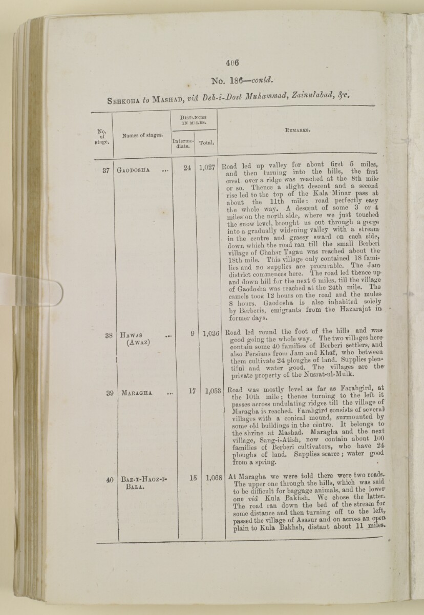
No. 186—
Sehkoha to Masiiad, vit Deh-i-Dod ZainulaUd,
Ko.
of
ptage.
Names of stages.
Distances
in MILES.
Interme
diate.
Total.
Kemaeks.
37
Giodosha
38
Hawas
(Awaz)
24
1,027
39
40
Maragha
1,036
17
Baz-i-Haoz-i-
Bala.
1,058
15
1,068
Road led up valley for about first 5 miles,,
and then turning into the hills, the first
crest over a ridge was reached at the 8th mile-
or so. Thence a slight descent and a second
rise" led to the top of the Kala Minar pass at-
about the 11th mile: road perfectly easy
the whole way. A descent of some 3 or 4
miles' on the north side, where we just touched
the snow level, brought us out through a gorge
into a gradually widening valley with a stream
in the centre and grassy sward on each side,
down which the road ran till the small Berberi
village of Chahar Tagau was reached about the-
ISth'mile. This, village only contained 18 fami
lies and no supplies are procurable. The Jam
district commences here. The road led thence up
and down hill for the next 6 miles, till the village
of Gaodosha was reached at the 24th mile. The
camels tooiv 12 hours on the road and the mules^
8 hours. Gaodosha is also inhabited solely
by Berberis, emigrants from the Hazarajat in
former days.
Road led round the foot of the hills and was-
good going the whole way. The two villages here-
contain some 40 families of Berberi settlers, and
also Persians from Jam and Khaf, who between
them cultivate 24 ploughs of land. Supplies plen
tiful and water good. The villages are the
private property of the Nusrat-ul-Mulk.
Road was mostly level as far as Farahgird, at
the 10th mile; thence turning to the left it
passes across undulating ridges till the village of
Maragha is reached. Farahgird consists of several
villages with a conical mound, surmounted by
some old buildings in the centre. It belongs to
the shrine at Mashad. Maragha and the next
village, Sang-i-Atish, now contain about 100
families of Berberi cultivators, who have 24
ploughs of land. Supplies scarce ; water good
from a spring.
At Maragha we were told there were two roads..
The upper one through the hills, whicb was said
to be difficult for baggage animals, and the lower
one via Kula Bakhsh. We chose the latter.
The road ran down the bed of the stream tor
some distance and then turning off to the lett,
passed the village of Asasur and on across an opett
plain to Kula Bakbsh, distant about 11 miles.
About this item
- Content
The volume is a Government of India official publication entitled Routes in Persia. Section III. Compiled in the Intelligence Branch of the Quarter Master General's Department in India (Simla: printed at the Government Central Printing Office, 1898).
The volume contains details of all land routes (numbered 1-247) in Persia starting from Russian territory and extending south as far as a line drawn from Karmanshah [Kermānshāh] south-eastwards through Burujird [Borūjerd], Isfahan [Eşfahān] and Yazd to Karman [Kermān], and thence north-east to Khabis [Khabīş] and Neh to Lash Juwain [Lāsh-e Juwayn].
The information given for each route comprises:
- number of route;
- place names forming starting point and destination of route;
- authority and date;
- number of stage;
- names of stages;
- distance in miles (intermediate and total);
- remarks (including precise details of the route, general geographical information, and information on smaller settlements, local peoples, agriculture, condition of roads, access to water, supplies of wood, and other routes).
An appendix within the volume (folios 356-359) and two separately-stored sets of loose sheets (containing routes numbers 77 (a) and 140-A, folios 363-369) give information too late for incorporation in the body of the work.
The volume also contains pockets attached to the front and back inside covers for maps. These consist of an index map showing the limits of each of the three sections of Routes in Persia (folio 2) and an index map to the routes in Section III (folio 361). There is also a fold-out map of the route from Seistan [Sīstān] to Mashad on folio 232.
An ink stamp on the front cover records the confidential nature of the publication and that it was being transmitted for the information of His Excellency the Viceroy (Victor Alexander Bruce, 9th Earl of Elgin and 16th Earl of Kincardine) only.
- Extent and format
- 1 volume (367 folios)
- Arrangement
The volume contains an alphabetical cross index (folios 6-17), and an alphabetical index to names of places (folios 18-25).
- Physical characteristics
Foliation: the foliation sequence commences at the front cover and terminates on the last page of the loose supplementary sheets (found in the small grey folder within the main folder); these numbers are written in pencil, are circled, and are located in the top right corner of the recto The front of a sheet of paper or leaf, often abbreviated to 'r'. side of each folio.
Pagination: the volume also contains a printed pagination sequence.
- Written in
- English in Latin script View the complete information for this record
Use and share this item
- Share this item
'ROUTES IN PERSIA. SECTION III' [230v] (465/739), British Library: India Office Records and Private Papers, Mss Eur F111/371, in Qatar Digital Library <https://www.qdl.qa/archive/81055/vdc_100024054422.0x000040> [accessed 24 April 2024]
https://www.qdl.qa/en/archive/81055/vdc_100024054422.0x000040
Copy and paste the code below into your web page where you would like to embed the image.
<meta charset="utf-8"><a href="https://www.qdl.qa/en/archive/81055/vdc_100024054422.0x000040">'ROUTES IN PERSIA. SECTION III' [‎230v] (465/739)</a> <a href="https://www.qdl.qa/en/archive/81055/vdc_100024054422.0x000040"> <img src="https://iiif.qdl.qa/iiif/images/81055/vdc_100000001491.0x000114/Mss Eur F111_371_0463.jp2/full/!280,240/0/default.jpg" alt="" /> </a>
This record has a IIIF manifest available as follows. If you have a compatible viewer you can drag the icon to load it.https://www.qdl.qa/en/iiif/81055/vdc_100000001491.0x000114/manifestOpen in Universal viewerOpen in Mirador viewerMore options for embedding images
Copyright: How to use this content
- Reference
- Mss Eur F111/371
- Title
- 'ROUTES IN PERSIA. SECTION III'
- Pages
- front, back, spine, edge, head, tail, front-i, 2r:58r, 59r:232r, 232r:233r, 234r:361v, back-i, 363r:363v, 365r:369v
- Author
- East India Company, the Board of Control, the India Office, or other British Government Department
- Usage terms
- Open Government Licence