!['ROUTES IN PERSIA. SECTION III' [‎299r] (602/739)](https://iiif.qdl.qa/iiif/images/81055/vdc_100000001491.0x000114/Mss Eur F111_371_0602.jp2/full/!1200,1200/0/default.jpg "'ROUTES IN PERSIA. SECTION III' [‎299r] (602/739)")
'ROUTES IN PERSIA. SECTION III' [299r] (602/739)
The record is made up of 1 volume (367 folios). It was created in 1898. It was written in English. The original is part of the British Library: India Office The department of the British Government to which the Government of India reported between 1858 and 1947. The successor to the Court of Directors. Records and Private Papers Documents collected in a private capacity. .
Transcription
This transcription is created automatically. It may contain errors.
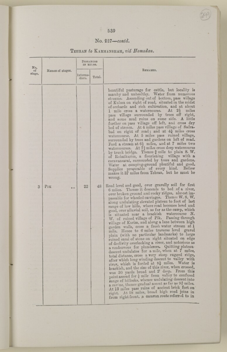
539
No. %%l~*~contd.
Tehran to Karmanshah, via Hamad an.
No.
D istances
in miles.
BEMiEKS,
of
stage.
Names of stages.
Interme
diate.
Total.
beautiful pasturage for cattle, "but locality is
marshy and unhealthy. Water from numerous
streams. Ascending out of bottom, pass village
of Kulma on right of road, situated in the midst
of orchards aud rich cultivation, and at about
1 mile cross a watercourse. At miles
pass village surrounded by trees off right,
and some mud ruins on same side. A little
further on pass village off left, and cross dry
bed of stream. At 4 miles pass village of Sadra-
bad on right of road; and at 4J miles^ cross
watercourse. At 5 miles pass ruined village^
surrounded by trees and gardens on left of road.
Ford a stream at 6^ miles, and at 7 miles two
watercourses. At 7* miles cross deep watercourse-
by trunk bridge. Thence f mile to plain S. W*
of liobatkarim, a flourishing village with a
caravansarai, surrounded by trees and gardens-
Water at camping-ground plentiful and good.
Supplies procurable of every kind. Bel lew-
makes it 37 miles from Tehran, but he must h&
wrong*
3
PlK
22
48
Road level and good, over gravelly soil for first
6 miles. Thence it descends to bed of a riyer r
over broken ground and rocky ridges, almost im
passable for wheeled carriages. Thence W. S. W.
along undulating elevated plateau to foot of last
range of low hills, where road becomes level and
good, over alluvial soil, as far as the camp, which
is situated near a brackish watercourse N.
W. of ruined village of Pik. Passing through
village of Karim, and along a lane between high
o-arden walls, cross a fresh water stream at 1
mile. Hence to 6 miles traverse level gravel
plain (with no particular landmarks) to large
ruined sarai of stone on right situated on edge
of declivity overlooking a river, and notorious as
a rendezvous for plunderers. Quitting plateau
descent undulates for a mile, when at 7 miles,
total distance, cross a very steep rugged ridge,
after which long winding descent to valley with
river, which is forded at 8i miles. Water is
brackish, and the size of this river, when crossed,
was 30 yards broad and 2' deep. From this
point ascend for i mile from valley to confused
lano -e of hillocks, whence undulating descent into
a ravine, thence gradual ascent as far as 9f miles.
At 13 miles pass ruins of ancient bnck fort on
right. At 18 miles, broad high road joins in
from right front, a caravan route referred to in
About this item
- Content
The volume is a Government of India official publication entitled Routes in Persia. Section III. Compiled in the Intelligence Branch of the Quarter Master General's Department in India (Simla: printed at the Government Central Printing Office, 1898).
The volume contains details of all land routes (numbered 1-247) in Persia starting from Russian territory and extending south as far as a line drawn from Karmanshah [Kermānshāh] south-eastwards through Burujird [Borūjerd], Isfahan [Eşfahān] and Yazd to Karman [Kermān], and thence north-east to Khabis [Khabīş] and Neh to Lash Juwain [Lāsh-e Juwayn].
The information given for each route comprises:
- number of route;
- place names forming starting point and destination of route;
- authority and date;
- number of stage;
- names of stages;
- distance in miles (intermediate and total);
- remarks (including precise details of the route, general geographical information, and information on smaller settlements, local peoples, agriculture, condition of roads, access to water, supplies of wood, and other routes).
An appendix within the volume (folios 356-359) and two separately-stored sets of loose sheets (containing routes numbers 77 (a) and 140-A, folios 363-369) give information too late for incorporation in the body of the work.
The volume also contains pockets attached to the front and back inside covers for maps. These consist of an index map showing the limits of each of the three sections of Routes in Persia (folio 2) and an index map to the routes in Section III (folio 361). There is also a fold-out map of the route from Seistan [Sīstān] to Mashad on folio 232.
An ink stamp on the front cover records the confidential nature of the publication and that it was being transmitted for the information of His Excellency the Viceroy (Victor Alexander Bruce, 9th Earl of Elgin and 16th Earl of Kincardine) only.
- Extent and format
- 1 volume (367 folios)
- Arrangement
The volume contains an alphabetical cross index (folios 6-17), and an alphabetical index to names of places (folios 18-25).
- Physical characteristics
Foliation: the foliation sequence commences at the front cover and terminates on the last page of the loose supplementary sheets (found in the small grey folder within the main folder); these numbers are written in pencil, are circled, and are located in the top right corner of the recto The front of a sheet of paper or leaf, often abbreviated to 'r'. side of each folio.
Pagination: the volume also contains a printed pagination sequence.
- Written in
- English in Latin script View the complete information for this record
Use and share this item
- Share this item
'ROUTES IN PERSIA. SECTION III' [299r] (602/739), British Library: India Office Records and Private Papers, Mss Eur F111/371, in Qatar Digital Library <https://www.qdl.qa/archive/81055/vdc_100024054423.0x000001> [accessed 10 May 2024]
https://www.qdl.qa/en/archive/81055/vdc_100024054423.0x000001
Copy and paste the code below into your web page where you would like to embed the image.
<meta charset="utf-8"><a href="https://www.qdl.qa/en/archive/81055/vdc_100024054423.0x000001">'ROUTES IN PERSIA. SECTION III' [‎299r] (602/739)</a> <a href="https://www.qdl.qa/en/archive/81055/vdc_100024054423.0x000001"> <img src="https://iiif.qdl.qa/iiif/images/81055/vdc_100000001491.0x000114/Mss Eur F111_371_0602.jp2/full/!280,240/0/default.jpg" alt="" /> </a>
This record has a IIIF manifest available as follows. If you have a compatible viewer you can drag the icon to load it.https://www.qdl.qa/en/iiif/81055/vdc_100000001491.0x000114/manifestOpen in Universal viewerOpen in Mirador viewerMore options for embedding images
Copyright: How to use this content
- Reference
- Mss Eur F111/371
- Title
- 'ROUTES IN PERSIA. SECTION III'
- Pages
- front, back, spine, edge, head, tail, front-i, 2r:58r, 59r:232r, 232r:233r, 234r:361v, back-i, 363r:363v, 365r:369v
- Author
- East India Company, the Board of Control, the India Office, or other British Government Department
- Usage terms
- Open Government Licence