!['ROUTES IN PERSIA. SECTION III' [‎309v] (623/739)](https://iiif.qdl.qa/iiif/images/81055/vdc_100000001491.0x000114/Mss Eur F111_371_0623.jp2/full/!1200,1200/0/default.jpg "'ROUTES IN PERSIA. SECTION III' [‎309v] (623/739)")
'ROUTES IN PERSIA. SECTION III' [309v] (623/739)
The record is made up of 1 volume (367 folios). It was created in 1898. It was written in English. The original is part of the British Library: India Office The department of the British Government to which the Government of India reported between 1858 and 1947. The successor to the Court of Directors. Records and Private Papers Documents collected in a private capacity. .
Transcription
This transcription is created automatically. It may contain errors.
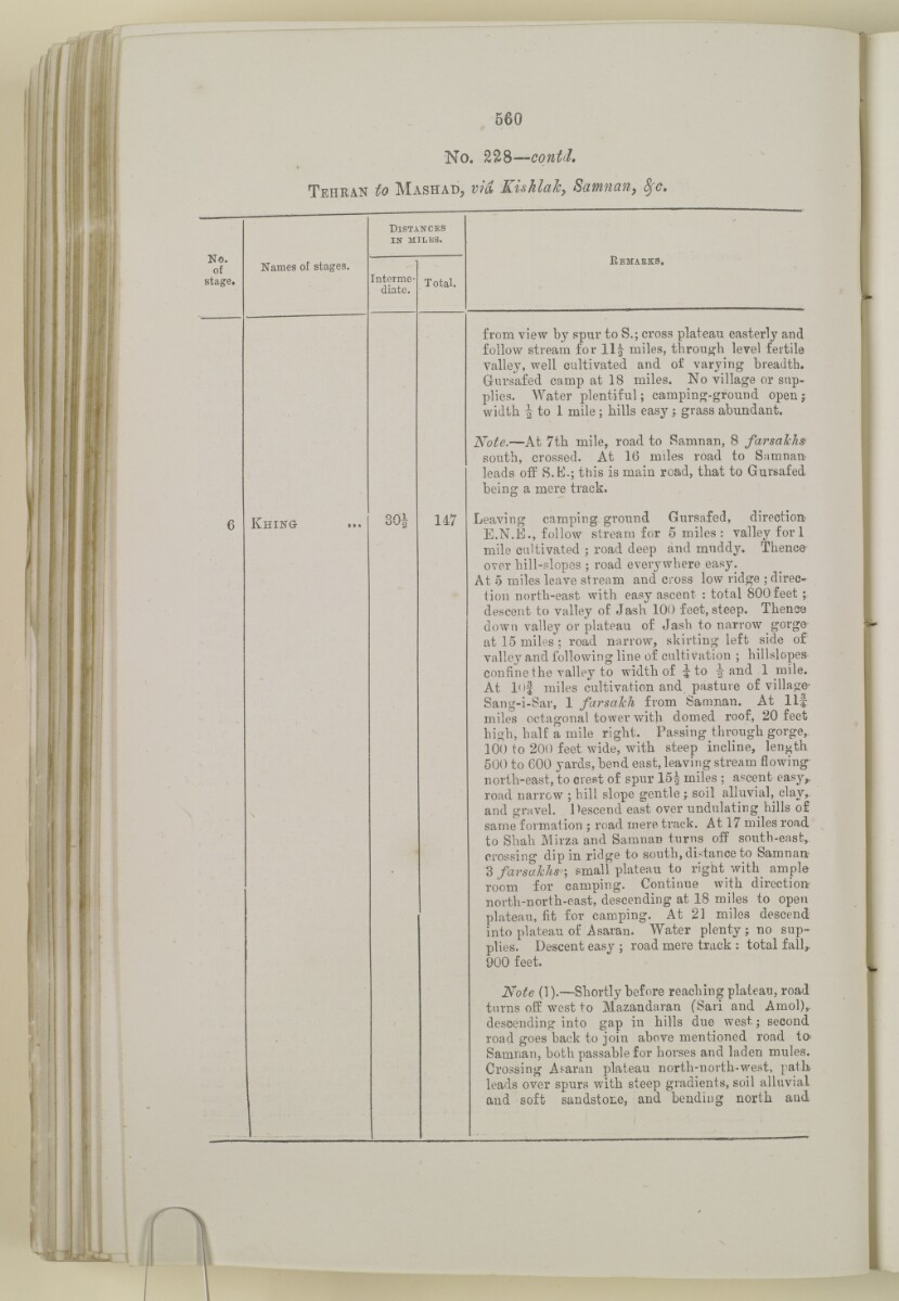
560
No. ZlS—contd.
Tehran to Mashad, via Kuhlaic, Samnan, 8fc,
Names of stages.
KHING
Distances
in miles.
Interme
diate.
Total.
147
Kemabks,
from view by spur to S.; cross plateau easterly and
follow stream for 11§ miles, through level fertile
Valley, well cultivated and of varying breadth.
Gursafed camp at 18 miles. No village or sup
plies. Water plentiful; camping-ground open f
width ^ to 1 mile; bills easy; grass abundant.
Note. —At 7th mile, road to Samnan, 8 farsalchs
south, crossed. At 16 miles road to Samnan-
leads off S.K.; this is main road, that to Gursafed
being a mere track.
Leaving camping ground Gursafed, direction
E.N.E., follow stream for 5 miles: valley fori
mile cultivated ; road deep and muddy. Thence
over hill-slopes ; road everywhere easy.
At 5 miles leave stream and cross low ridge ; direc^
tion north-east with easy ascent : total 800 feet j
descent to valley of Jash 100 feet, steep. Thenoe
down valley or plateau of Jash to narrow gorge-
at 15 miles ; road narrow, skirting left side of
valley and following line of cultivation ; hillslopes-
confine the valley to width of ^ to ^ and 1 mile.
At 10j miles cultivation and pasture of village-
Sang-i-Sar, 1 farsalch from Samnan. At llf
miles octagonal tower with domed roof, 20 feet
high, half a mile right. Passing through gorge,
100 to 200 feet wide, with steep incline, length
500 to 600 yards, bend east, leaving stream flowing
north-east, to crest of spur 15 J miles ; ascent easy^
road narrow ; hill slope gentle j soil alluvial, clay,,
and gravel. Descend east over undulating hills of
same formation ; road mere track. At 17 miles road
to Shah Mirza and Samnan turns off south-east^
crossing dip in ridge to south, distance to Samnart
3 farsafchs ; small plateau to right with ample
room for camping. Continue with direction
north-north-east, descending at 18 miles to open
plateau, fit for camping. At 21 miles descend
into plateau of Asaran. Water plenty ; no sup
plies. Descent easy ; road mere track : total fall,,
900 feet.
Note (1).—Shortly before reaching plateau, road
turns off west to Mazandaran (Sari and Amol)^
descending into gap in hills due west; second
road goes back to join above mentioned road to
Samnan, both passable for horses and laden mules.
Crossing A^aran plateau north-north-west, path
leads over spurs with steep gradients, soil alluvial
and soft sandstone, and bending north and
About this item
- Content
The volume is a Government of India official publication entitled Routes in Persia. Section III. Compiled in the Intelligence Branch of the Quarter Master General's Department in India (Simla: printed at the Government Central Printing Office, 1898).
The volume contains details of all land routes (numbered 1-247) in Persia starting from Russian territory and extending south as far as a line drawn from Karmanshah [Kermānshāh] south-eastwards through Burujird [Borūjerd], Isfahan [Eşfahān] and Yazd to Karman [Kermān], and thence north-east to Khabis [Khabīş] and Neh to Lash Juwain [Lāsh-e Juwayn].
The information given for each route comprises:
- number of route;
- place names forming starting point and destination of route;
- authority and date;
- number of stage;
- names of stages;
- distance in miles (intermediate and total);
- remarks (including precise details of the route, general geographical information, and information on smaller settlements, local peoples, agriculture, condition of roads, access to water, supplies of wood, and other routes).
An appendix within the volume (folios 356-359) and two separately-stored sets of loose sheets (containing routes numbers 77 (a) and 140-A, folios 363-369) give information too late for incorporation in the body of the work.
The volume also contains pockets attached to the front and back inside covers for maps. These consist of an index map showing the limits of each of the three sections of Routes in Persia (folio 2) and an index map to the routes in Section III (folio 361). There is also a fold-out map of the route from Seistan [Sīstān] to Mashad on folio 232.
An ink stamp on the front cover records the confidential nature of the publication and that it was being transmitted for the information of His Excellency the Viceroy (Victor Alexander Bruce, 9th Earl of Elgin and 16th Earl of Kincardine) only.
- Extent and format
- 1 volume (367 folios)
- Arrangement
The volume contains an alphabetical cross index (folios 6-17), and an alphabetical index to names of places (folios 18-25).
- Physical characteristics
Foliation: the foliation sequence commences at the front cover and terminates on the last page of the loose supplementary sheets (found in the small grey folder within the main folder); these numbers are written in pencil, are circled, and are located in the top right corner of the recto The front of a sheet of paper or leaf, often abbreviated to 'r'. side of each folio.
Pagination: the volume also contains a printed pagination sequence.
- Written in
- English in Latin script View the complete information for this record
Use and share this item
- Share this item
'ROUTES IN PERSIA. SECTION III' [309v] (623/739), British Library: India Office Records and Private Papers, Mss Eur F111/371, in Qatar Digital Library <https://www.qdl.qa/archive/81055/vdc_100024054423.0x000016> [accessed 10 May 2024]
https://www.qdl.qa/en/archive/81055/vdc_100024054423.0x000016
Copy and paste the code below into your web page where you would like to embed the image.
<meta charset="utf-8"><a href="https://www.qdl.qa/en/archive/81055/vdc_100024054423.0x000016">'ROUTES IN PERSIA. SECTION III' [‎309v] (623/739)</a> <a href="https://www.qdl.qa/en/archive/81055/vdc_100024054423.0x000016"> <img src="https://iiif.qdl.qa/iiif/images/81055/vdc_100000001491.0x000114/Mss Eur F111_371_0623.jp2/full/!280,240/0/default.jpg" alt="" /> </a>
This record has a IIIF manifest available as follows. If you have a compatible viewer you can drag the icon to load it.https://www.qdl.qa/en/iiif/81055/vdc_100000001491.0x000114/manifestOpen in Universal viewerOpen in Mirador viewerMore options for embedding images
Copyright: How to use this content
- Reference
- Mss Eur F111/371
- Title
- 'ROUTES IN PERSIA. SECTION III'
- Pages
- front, back, spine, edge, head, tail, front-i, 2r:58r, 59r:232r, 232r:233r, 234r:361v, back-i, 363r:363v, 365r:369v
- Author
- East India Company, the Board of Control, the India Office, or other British Government Department
- Usage terms
- Open Government Licence